< SC 7 | Home | SC 9 >
|
|
|
| ROUTE LOG |
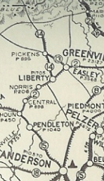
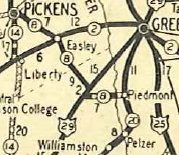
US 25, SC 418: 0 - 0 Anderson-Greenville Line: 4.0 - 4.0 SC 20: 0.7 - 4.7 US 29: 3.4 - 8.1 I-85 (exit 32): 1.1 - 9.2 SC 81 SB: 1.5 - 10.7 SC 81 NB: 2.0 - 12.7 SC 88: 0.3 - 13 SC 86: 3.5 - 16.5 Pickens-Anderson Line: 1.2 - 17.7 SC 135: 3.1 - 20.8 US 123: 0.4 - 21.2 SC 93: 1.0 - 22.2 SC 183 WB: 6.8 - 29.0 SC 183 EB: 0.4 - 29.4 SC 186: 3.2 - 32.6 SC 135: 5.4 - 38.0 SC 288: 0.6 - 38.6 SC 11 WB: 3.9 - 42.5 SC 11 EB: 0.5 - 43.0 Greenville-Pickens Line: 1.3 - 44.3 US 276: 0.3 - 44.6
|
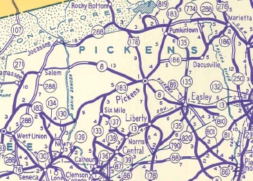
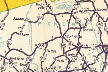
Creation: Appeared in 1928 as a renumbering of of SC 13 from SC 14 (now US 178) Picken to Easley, then continued southeast as new construction to end at SC 20 Piedmont. This is the 2nd SC 8.
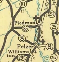
| Adjustments: In July 1936 (SCDOT), SC 8 was rerouted at SC 81 to instead continue southeast as new primary routing through Pelzer and ending at US 25 Ware Place. The old route to Piedmont became SC 85 (now SC 86 and S-4-17).
In 1940, SC 8 was removed from Walkers Mill Rd west of Ware Place. In 1942, SC 8 was extended west with SC 183 out of Pickens a mile, then northwest as new primary routing through Nine Times to end at the Keowee River at Shallow Ford Bridge. In 1947, SC 8 west was truncated back to Pickens, leaving behind SC 183 and S-39-32. West of Nine Times this is now SC 133, a little Cedar Creek Rd, abandoned routing through Keowee-Toxaway State Park, and Old Shallowford Bridge Rd.
In 1956, SC 8 was extended northeast from Pickens, replacing SC 183 to end at SC 11-288 Pumpkintown. In 1971, SC 8 was extended north replacing SC 11 to end at US 276 near Caesars Head. Sometime in the 1990s the southeastern end of SC 8 was rebuilt to no longer touch SC 247. Sometime after 1994 SC 8 was removed from 5th St at the northern SC 8-135 split.
Improvements: In 1930, SC 8 was paved US 29 (now SC 81) north to Pickens. In 1931, SC 8 was paved from US 29 (now SC 81) to Piedmont making SC 8 fully paved. After the 1938 rerouting, SC 8 was UNpaved from Pelzer to Ware Place SC 8 was paved from Pelzer to Ware Place in 1940. The 1942 western extension to the Keowee River had an unpaved section on the western few miles. The 1948 rescinding of the Pickens-west routing finally brought SC 8 to a fully paved route. SC 8 was multilaned from Pickens to Easly between 1966-67. Official maps from 1990-2006 stopped showing this for some reason. Comment: SC 8 is part of a useful short cut from I-385 to Clemson via SC 418 and SC 88. Otherwise SC 8 is a non-descript route essentially serving eastern Pickens County. | Previous SC 8's:
1927 ROUTE LOG GA STATE LINE: 0 - 0 SC 18 SB, SC 81: 15.4 - 15.4 SC 15 EB: 0.5 - 15.9 SC 18 NB: 0.1 - 16.0 SC 15 WB: 0.7 - 16.7 SC 2 WB: 31.5 - 48.2 SC 20: 0.2 - 48.4 US 25 SB, SC 21 SB: 0.2 - 48.6 US 76, SC 2 EB,: 0.7 - 49.3 US 25 NB, SC 21 NB: 1.0 - 50.3 US 176, SC 10, SC 19: 34.1 - 84.4 SC 11: 21.5 - 105.9 SC 5: 8.8 - 114.7 NC STATE LINE: 5.5 - 120.2 |
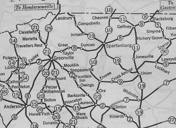
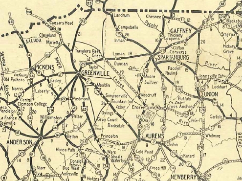
SC 8 #1: An original state route. Ran from the Georgia State Line near Hartwell Ga proceeding northwest through Anderson, Greenville, Greer, Spartanburg, and Gaffney before entering North Carolina east of Blacksburg.
In 1924 (bridge date), SC 8 was removed from Main St in Converse to nstead follow Old Converse Rd and today's US 29 over the Pacolet River. By 1926 it appears SC 8 was removed from S-23-109 Fairview Rd/SC 290 betwen Taylors and Greer; also from Old Charlotte Rd east of Spartanburg By 1927, it appears SC 8 was removed from the following: S-42-645S-42-646 through Wellford; S-42-317 loop west of I-26; S-42-1550 Main St/Vanderbilt Rd west of Spartanburg; S-42-817 Old Converse Rd and Harris In 1928, SC 8 was eliminated in favor of US 29. Today it is under Lake Hartwell at the state line (2.6 miles north of current US 29 crossing); "Old 29" north of SC 412; US 29 to Anderson except George Merck Rd loop; US 29 Business into downtown Anderson; SC 81 to Greenville except S-4-371 Bradley Rd and A M Ellison Rd loops south of I-85, Irby Rd loop north of I-85, S-4-52 Powdersville Rd/S-4-74 Three Bridges Rd/SC 153 in the Powdersville area, S-4-143 Old Anderson Rd and Old Anderson Rd on both sides of the Saluda River bridge; Anderson St/Main St/Buncombe Ave through Greenville; S-23-21 northeast out of Greenville; S-23-38 through Taylors; US 29; SC 290 through Greer to Duncan; SC 292 to Lyman; S-42-316 Spartanburg Rd through Wellford; US 29 to Spartanburg; Main St through Downtown Spartanburg; US 29 to the NC Line except in Gaffney it used Granard St to Mills St instead of cutting the corner as US 29 does now.
|
|||||||||||||||


Previous: SC 7 |
Next: SC 9
Top | South Carolina Hwy Index
Home
Page last modified 11 August 2017