< SC 32 | Home | SC 33 ALT | SC 34 >
|
|
|
| ROUTE LOG |
US 301, US 601: 0 - 0 US 178 Bus: 0.5 - 0.5 US 21 Bus, US 601: 0.7 - 1.2 US 21, US 178: 0.8 - 2 I-26 (exit 149): 3.2 - 5.2 Calhoun-Orangeburg Line: 4.0 - 9.2 US 176: 1.4 - 10.6 SC 6: 4.6 - 15.2 SC 267: 3.8 - 19.0
|
Creation: SC 33 was an original state route running from SC 1 (now US 278) Fairfax north through Bamberg to end at SC 4 Orangeburg. This is the only SC 33.
| Adjustments: In 1923 or 1924, SC 33 was extended south as new primary routing through Estill to end at SC 1 (now US 17) Hardeeville.
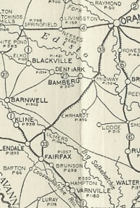
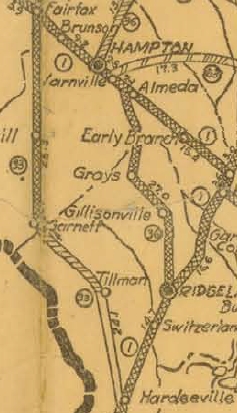
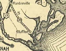
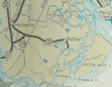
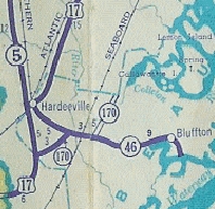
About 1928, SC 33 was extended east from Hardeeville as new primary routing to end at Bluffton. In July 1936 (SCDOT), SC 33 was extended through Bluffton to end at Brighton Beach. The original SC 33 ending at the May River waterfront became SC 33 ALT (now S-7-66 and S-7-31). In 1939, SC 33 south was truncated to SC 5 (now US 321) north of Ulmers leaving behind SC 5 to Hardeeville, SC 5 ALT in Hardeeville and SC 46 to Brighton Beach. Today this is US 321, SC 46, S-7-66 and S-7-13. SC 33 almost certainly used S-27-176 loops east of Hardeeville.
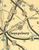
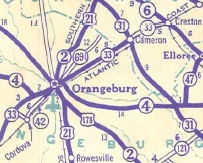
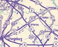
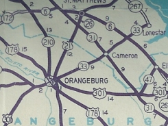
Also in 1939, SC 33 was extended with SC 4 into Orangeburg, then replaced SC 69 to end at SC 6 Creston. Some of this was newly constructed alignment. In 1940, SC 33 was extended northeast as new primary routing to end at SC 47 (now SC 267) Lone Star. In 1947, SC 33 south was truncated to US 301 (now S-38-1) in eastern Orangeburg. The route to Ulmers became part of US 301.
In 1954, SC 33 was re-extended through Orangeburg to its current endpoint, replacing US 301.
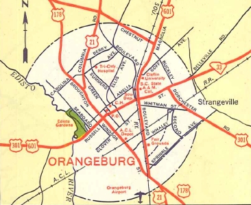
Improvements: The first piece of SC 33 to be paved was between Hardeeville and Bluffton, in 1931. SC 33 was paved between Garnett and Fairfax in 1933. In 1934, SC 33 was paved between Hardeeville and Garnett and from Bamberg to Orangeburg. In 1935, SC 33 was paved from Fairfax to Sycamore. In 1937, SC 33 was paved from Sycamore to the Allendale-Bamberg Line. The remainder of SC 33 from there to Bamberg was paved in 1939. SC 33 was paved from Orangeburg to Cameron when designated in 1940. The remainder of SC 33 was paved by 1948. SC 33 was multilaned from Orangeburg out to I-26 in 1979. Comment: SC 33 serves the lovely Edisto River Gardens, as well as downtown Orangeburg. | ||||||||||||||||

Previous: SC 32 |
Next: SC 33 ALT | SC 34
Top | South Carolina Hwy Index
Home
Page last modified 19 March 2016