< SC 68 | Home | SC 70 >
| SC 69 not currently assigned | ||||||||||
| Previous SC 69's: 1937 ROUTE LOG SC 4: 0 - 0 SC 31: 9 - 9 1946 ROUTE LOG SC 546: 0 - 0 US 178: 3.0 - 3.0 SC 6: 6.7 - 9.7 1980 ROUTE LOG US 17: 0 - 0 US 17: 5.7 - 5.7 |
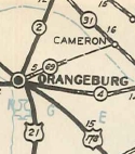
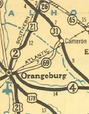
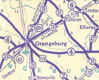
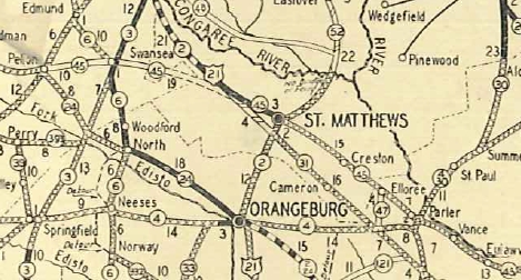
SC 69 #1: Created in 1934 or 1935 as new primary routing. Ran from SC 4 (now S-38-1) Orangeburg east about 5 miles.
In July 1936 (SCDOT), SC 69 was extended west as new primary routing to end at SC 31 (now US 176) Cameron. In 1938 SC 69 was renumbered as part of SC 33. The 1938 Official Map clearly shows it south of the railroad tracks in Orangeburg County. This means SC 69 used Myers Rd, S-38-1445, S-38-1863, and several unnumbered dirt roads.
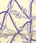
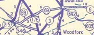
SC 69 #2: Created in 1939 as a renumbering of part of SC 45 from SC 6 Swansea west to US 178 Pelion. In 1942, SC 69 was rerouted to run southwest across US 178 and ending at SC 546 (now S-32-45). The old route to Pelion remained secondary and is now S-32-246. In 1947, SC 69 was downgraded to S-32-55 west of S-32-246 (this is now S-32-9 east of US 178) and S-32-9 east of S-32-246.
SC 69 #3: Appeared in 1977 as new primary routing. Ran from US 17 Atlantic Beach up to Cherry Grove Beach replacing S-26-25, then cut west back to US 17 at its Intracoastal Waterway bridge. The piece cutting back to US 17 over S-26-20 was once part of SC 9. In 1981, SC 69 was renumbered as SC 65. The northern connection back to US 17 is now part of SC 9.
| |||||||||


Previous: SC 68 |
Next: SC 70
Top | South Carolina Hwy Index
Home
Page last modified 7 November 2015