< SC 49 | Home | SC 51 >
| SC 50 not currently assigned | ||||||
| Previous SC 50's: 1926 ROUTE LOG SC 2: 0 - 0 SC 34 WB: 28.6 - 28.6 SC 26, SC 34 EB: 3.7 - 32.3 SC 34 EB: 1.4 - 33.7 SC 35: 25.7 - 59.4 SC 41: 26.5 - 85.9 SC 9 WB, SC 96: 3.0 - 88.9 SC 9 EB: 2.0 - 90.9 NC STATE LINE: 9.5 - 100.4 1946 ROUTE LOG US 21, SC 5: 0 - 0 END SC 50: 1.2 - 1.2 |
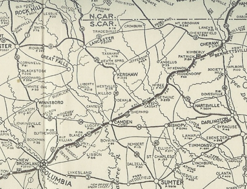
SC 50 #1: An original state highway, running from the corner of Assembly (SC 2 then) and Taylor St in Columbia, then headed northeast on Two Notch Road to Camden, Bethune, McBee, and Cheraw before heading into North Carolina. The route continued as NC 50.
In late 1926, US 1 was assigned to the entirety of SC 50. About 1927, SC 50 was put on US 1's modern routing between McBee and Patrick, bypassing Middendorf. SC 50 had used S-13-63 to Middendorf; unpaved Middendorf Church Rd; S-13-29 to McKennon; unpaved TT 10 Rd which no longer crosses the RR back to US 1 below the Cow Creek Bridge in Patrick In 1928, SC 50 was dropped, leaving behind US 1. SC 50 used US 1 from Columbia to Kershaw County; S-28-102 to Elgin; S-28-21 Smyrna Rd; S-28-349 Wildwood Ln; SC 34 to Lugoff; US 1 through Camden, Bethune, McBee and Patrick; McLain/Griggs/Emma Rd out of Patrick; abandoned alignment east of US 1 connecting with S-13-232 through Cheraw State Park; abandoned routing to connect to Old Cash Rd then Howard Alley/2nd St to Cheraw; Church St east across the Pee Dee River, then north on S-35-36 to US 1 through the Kollock area and to North Carolina. SC 50 was routed along three national trail routes in 1922: National Highway, Capitol Trail, and Atlantic Highway. SC 50 was the highest number in the original system.
| |||||
Previous: SC 49 |
Next: SC 51
Top | South Carolina Hwy Index
Home
Page last modified 18 January 2016


