SC 94 
< SC 93 | Home | SC 95 >
SC 94  not currently assigned
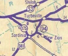
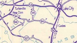
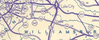
Previous SC 94's:

1937 ROUTE LOG
SC 9: 0 - 0
NC STATE LINE: 1.9 - 1.9


1946 ROUTE LOG
SC 54: 0 - 0
US 301: 3.4 - 3.4
SC 942: 1.3 - 4.7
SC 941: 4.1 - 8.8
Williamsburg-Clarendon Line: 1.7 - 10.5
SC 541: 2.4 - 12.9
US 52: 6.9 - 19.8
SC 175: 12.0 - 31.8
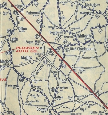
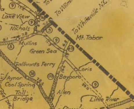
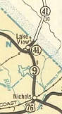
SC 94 #1: Appeared in 1925 or 1926 as a renumbering of SC 47 running from SC 9 Lake View to the nearby North Carolina line.
In 1938, SC 94 was renumbered as SC 41. Today it is still SC 41 except right in Lake View it followed Main St down to SC 9 at 3rd St (this is SC 9-41 CONN).

1923 Auto Trails
SC 47
1923 Auto Trails
1926 Official
SC 94 replaces SC 47 north of Lake View
1926 Official
1938 Official
SC 94 renumbered as SC 41
1938 Official

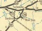
SC 94 #2: Appeared in 1938 as a renumbering of SC 41, running from US 301 east to New Zion.
In 1939, SC 94 was extended east 3 miles as new primary routing to end at today's S-14-19 in Douglas Swamp.
In 1940, SC 94 was extended east as new primary routing to US 52 Cades.
In 1942, SC 94 was extended east as new primary routing to SC 175 (now SC 261) Coopers and west as new primary routing to SC 54 near the Sumter County line.
In 1947, SC 94 was downgraded to S-14-9 (now S-14-37) from US 301 to New Zion; S-14-16 (now S-14-37) and S-14-17 (now S-14-37 and S-14-53); S-45-20 west of Cades (now S-45-28); S-45-28 (now SC 512) east of Cades.

1935 Official
SC 41 to New Zion
1935 Official
1938 Official
SC 94 replaces SC 41
1938 Official
1939 Official
SC 94 extended eastward
1939 Official
1940 Official
SC 94 extended to Cades
1940 Official
1942 Official
SC 94 extended both directions
1942 Official


Previous: SC 93  |  Next: SC 95
Top  |  South Carolina Hwy Index Home

Page last modified 23 October 2015