< SC 149 | Home | SC 151 >
|
|
|
|
| ROUTE LOG |
SC 56: 0 - 0 SC 215: 1.5 - 1.5 US 176: 7.6 - 9.1 SC 9: 1.2 - 10.3 Cherokee-Spartanburg Line: 3.3 - 13.6 SC 211: 1.7 - 15.3 SC 105 NB: 9.1 - 24.4 SC 105 SB: 0.1 - 24.5 SC 18 SB: 1.1 - 25.6 US 29 SB, SC 11: 0.1 - 25.7 US 29 NB: 0.1 - 25.8 SC 18 NB: 0.2 - 26.0 NC STATE LINE: 7.5 - 33.5
|
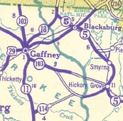
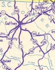
Creation: SC 150 appeared in 1940 as a renumbering of SC 103 from SC 18 ALT (now SC 18 CONN Logan St) Gaffney north to North Carolina. This is the only SC 150.
| Adjustments: In 1960, SC 150 was extended south to SC 56, replacing SC 18. Between 1964-67, SC 150 was removed from Logan St in Gaafney and instead continued to SC 18 to head to central Gaffney. Improvements: SC 150 was paved upon designation; no multilane segments Comment: SC 150 is blown off by I-85 but is signed from each direction of I-85 at the exits east and west of SC 150, with frontage roads that connect you to SC 150.
| ||||||

Previous: SC 149 |
Next: SC 151
Top | South Carolina Hwy Index
Home
Page last modified 9 September 2015