< TN 60 | Home | TN 62 >
|
|
|
| ROUTE LOG |
US 27 SB, US 70, TN 1, TN 29: 0 - 0 TN 382: 3.4 - 3.4 I-40 (exit 347): 2.1 - 5.5 TN 29 SB: 1.6 - 7.1 TN 328: 1.6 - 8.7 US 27 NB, TN 29 NB: 3.7 - 12.4 TN 327: 5.0 - 17.4 TN 62 WB, TN 330: 5.7 - 23.1 Anderson-Roane Line: 0.4 - 23.5 TN 62 EB: 3.0 - 26.5 TN 95: 7.2 - 33.7 US 25W, TN 9: 4.9 - 38.6 I-75 (exit 122): 5.7 - 44.3 US 441 NB, TN 71 NB: 1.8 - 46.1 US 441 SB, TN 71 SB: 0.1 - 46.2 Union-Anderson Line: 5.4 - 51.6 TN 170 EB: 5.9 - 57.5 TN 170 WB: 0.1 - 57.6 TN 33 SB: 4.7 - 62.3 TN 144 NB: 3.3 - 65.6 TN 144 SB: 0.3 - 65.9 TN 33 NB: 4.2 - 70.1 TN 370: 1.5 - 71.6 TN 131 NB: 2.4 - 74.0 TN 131 SB: 0.9 - 74.9 Knox-Union Line: 3.3 - 78.2 TN 331: 0.9 - 79.1 Grainger-Knox Line: 0.8 - 79.9 US 11W, TN 1: 1.2 - 81.1
|
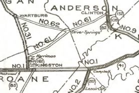
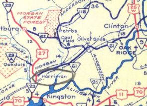
Creation: An original route that started out running from TN 31 (now TN 328) Harriman through Oliver Springs to TN 9 (now US 25W) Clinton.
| Adjustments: In 1927 or 1928, TN 61 east was extended to US 11 (now Indian Ridge Rd/Maple Dr intersection) Blaine.
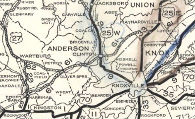
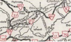
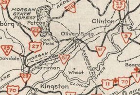
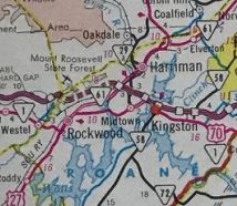
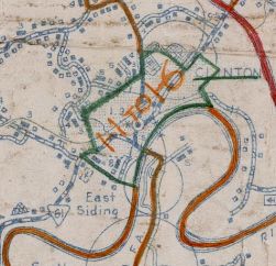
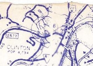
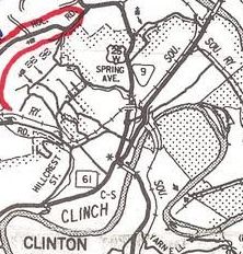
In the 1933-36 timeframe, Norris Lake was created. This affected TN 61 in Union County. The 1939 Union County map shows a gap in TN 61 from the Anderson Line to just north of today's TN 170 (although State Officials do not show a gap). The original route used today's Dock Rd and abandoned underwater routing. In 1938, TN 61 was given a much more direct route from Harriman to Oliver Springs. The old route used Webster Rd (except TN 61 ran much closer to the Emroy River bend) to Little Emory; went due east across abnadoned routing over Little Emory River; Clax Gap Rd to Clacks Gap; Mays Valley Rd and Dyllis Rd through Dyllis; Old Harriman Hwy through Jonesville and Orchard View, picking up Kingston Ave into Oliver Springs. By 1939, TN 61 east was truncated from US 11W to US 11W's new routing in Blaine, leaving behind Indian Ridge Rd (since altered). In 1941, Tennessee unsuccefully tried to get US 58 routed on TN 61 from Harriman to Clinton Between 1939-47, TN 61 was removed from Winter Gap Rd/Kingston Ave in central Oliver Springs and put on Railroad Ave to skirt downtown. About 1946, TN 61 was given its direct routing from the north edge of Oak Ridge to where TN 95 now ends. The old route was removed from the highway system. It used a bit of TN 62; Old Knoxvile Hwy; TN 62 to just past Outer Dr; abandoned routing s of TN 62 to near Hillside Rd where it used the east end of Hickory Ln and Raleigh Rd before picking up today's TN 95 which it used all the way to its end except for Elza Rd near the tie-in back to new TN 61. This may also have been when TN 61 was removed from Old Tacora Hills Rd west of Clinton and Hillcrest St/W Broad St within Clinton. About 1947, TN 61 was given its current routing through northern Harriman. The old route used the removed RR bridge on Whitier Ave and the zig-zaggy Old Roane St all the way out of town. In 1953 or 1954, TN 61 was extended southwest to US 70 Rockwood.
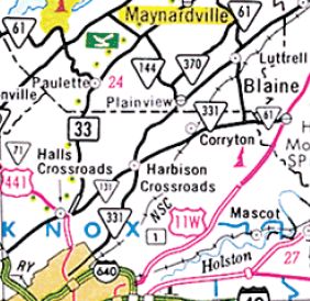
In 1957, TN 61 was removed from State St/Pansy Hill Rd in S Harriman; Emory Dr/Sewanee St/Morgan Ave in Harriman About 1965, TN 61 was removed from Hannah Dr and Midway Dr southeast of Oliver Springs. In 1966, TN 61 was removed from Old Maynardsville Hwy, Butler Ln and Karen Ln near Paulette; John Deere Dr through Raccoon Valley; Main St through Maynardsville In 1970, TN 61 was removed from Front St (discontinuous at Flat Creek) and Luttrell Main St in Luttrell. I believe around 1971, TN 61 was removed from Sinking Springs Rd between the Clinch River and I-75. In 1985, TN 61 was given its bypass of Oliver Springs, leaving behind W. Tri-County Blvd, TN 330 and Knox Ave. In 1987, TN 61 was removed from its US 25W overlay in Clinton plus Market St.
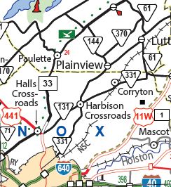
Between 1982-91, TN 61 was removed from Joe Owen Rd east of I-75 and Little Senator Circle at the US 441 junctions. In 2004, TN 61's east end was moved to accommodate the widening of US 11W by using Blaine Dr to connect, leaving behind a piece of Emory Rd which no longer connected to US 11W. In 2006, TN 61 was removed from Old State Hwy 61 south of Luttrell; also TN 61 was put on new routing in Knox County over to US 11W in Blaine, leaving behind an extended TN 331,
Posting: Posted as secondary routing from TN 62 to TN 95 and everywhere east of I-75; primary posting everywhere else The overlays with US 27, TN 33 and TN 62 are fully posted Secret US Route Overlay: US 27 (7.1 mi) Comment: TN 61 connects I-75 to Clinton and Oak Ridge Between I-75 and TN 33 is extremely gnarly looking | ||||||||||||||||
Previous: TN 60 |
Next: TN 62
Top | Tennessee Hwy Index
Home
Page last modified 19 November 2020