< TN 59 | Home | TN 61 >
|
|
|
| ROUTE LOG |
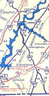
GA STATE LINE: 0 - 0 TN 317: 1.9 - 1.9 TN 311 EB: 8.9 - 10.8 US 64 Byp WB, US 74 WB, TN 311 WB: 0.2 - 11.0 TN 74: 0.3 - 11.3 US 64, US 64 Byp END, TN 40: 1.3 - 12.6 US 11 Bus, TN 74: 2.6 - 15.2 US 11, TN 2: 0.6 - 15.8 I-75 (exit 25): 1.1 - 16.9 TN 306: 3.0 - 19.9 Hamilton-Bradley Line: 4.6 - 24.5 TN 58: 1.1 - 25.6 TN 312: 4.6 - 30.2 Meigs-Hamilton Line: 2.0 - 32.2 Hamilton-Meigs Line: 3.2 - 35.4 Rhea-Hamilton Line: 0.2 - 35.6 US 27, TN 29, TN 378: 5.4 - 41.0
|
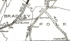
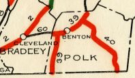
Creation: An original route that started out running from TN 2 (now TN 74) Cleveland to TN 39 (now Ward St) Benton.
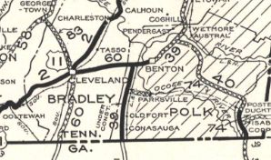
| Adjustments: About 1926, TN 60 east was replaced by and truncated to a rerouted TN 39 (now Mull Rd) south of Benton Station. Today TN 39 to Benton is just Benton Station Rd. In 1927 or 1928, TN 60 was extended from Cleveland south to the Georgia line as new state highway.
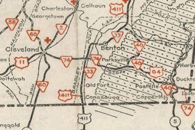
In 1939, TN 60 east was rerouted at Cleveland to instead replace TN 83 north to TN 58 Georgetown. The route to Benton was removed from the state highway system. Today it is Central Ave/Shepherd St/6th St in Cleveland and Benton Pike east to Mull Rd. In 1948, TN 60 was removed from Candies Creek Rd/Old Georgetown Rd near Hopewell. In 1951, TN 60 was extended north to US 27 (now TN 378) Dayton.
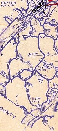
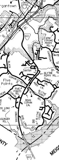
In 1953, TN 60 was removed from today's TN 306 and Old Georgetown Rd northwest out of Hopewell. About 1965, TN 60 was rerouted in Cleveland to follow US 11 north to 25th St, then west as new construction to Georgetown Rd. The old route used Harrison Pike (now TN 312) to Georgetown Rd NW. In 1976, TN 60 was rerouted at Inman St/US 64 to head east then placed on the bypass around the north of Cleveland. In 1983, TN 60 was rerouted onto McGrady Dr to reach the Cleveland Bypass southeast of town, then replaced TN 40 Byp around to the US 64 to pick back up with TN 60. North of McGrady along Dalton Pike to TN 74 became part of TN 311. From TN 74 to US 64 Inman St became part of an extended TN 74. In 1995, TN 60 was given its bridge over the Tennessee River and new routing to meet US 27/TN 378 on the south end of Dayton, leaving behind Shadden Rd and Blythe Ferry Rd east of the river; abandoned ferry; the lengthy Blythe Ferry Rd west of the river to Dayton (briefly interrupted bu current TN 60 near Five Points); Florida Ave in Dayton
Posting: Posted as primary routing east of I-75; secondary posting west of I-75 The overlay with US 64 Byp/74 is posted at the south split only Secret US Route Overlay: US 64 Byp-74 (1.6 mi) Comment: TN 60 was the last route to get rid of its Tennessee River ferry in eastern Tennessee. Connects Dayton to Cleveland to Dalton GA | ||||||||||||
Previous: TN 59 |
Next: TN 61
Top | Tennessee Hwy Index
Home
Page last modified 20 November 2020