< TN 67 | Home | TN 69 >
|
|
|
|
| ROUTE LOG |
GA STATE LINE: 0 - 0 US 64, US 74, TN 40: 3.5 - 3.5 TN 123: 10.0 - 13.5 Monroe-Polk Line: 8.9 - 22.4 TN 165: 14.6 - 37.0 TN 39: 0.5 - 37.5 US 411, TN 33: 11.8 - 49.3 TN 307: 5.1 - 54.4 US 11, TN 2: 4.2 - 58.6 I-75 (exit 60): 2.7 - 61.3 McMinn-Monroe Line: 0.2 - 61.5 Meigs-McMinn Line: 8.2 - 69.7 TN 305: 1.1 - 70.8 TN 58: 2.0 - 72.8 TN 304 NB: 2.8 - 75.6 TN 304 SB: 0.5 - 76.1 Rhea-Meigs Line: 1.1 - 77.2 TN 302: 4.5 - 81.7 US 27 SB, TN 29 SB: 1.4 - 83.1 US 27 NB, TN 29 NB: 2.3 - 85.4 Cumberland-Rhea Line: 8.3 - 93.7 US 127, TN 28: 12.6 - 106.3
|
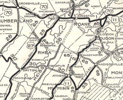
Creation: Appeared in 1927 or 1928 running from TN 28 (now US 127) Homestead southeast via Spring City, Sweetwater and Madisonville to end at Tellico Plains. This is the 2nd TN 68.
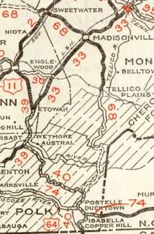
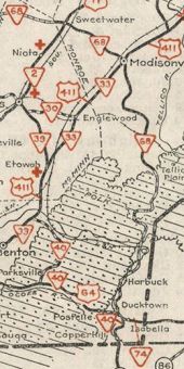
| Adjustments: In 1931 or 1932, TN 68 was extended south to TN 40 (now Kimsey Mountain Hwy) Harbuck. In 1939, TN 68 was extended south to US 64 Duckville, replacing some of TN 40. Between 1941-43, TN 68 was extended south to the Georgia Line at Copper Hill, replacing more of TN 40.
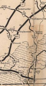
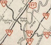
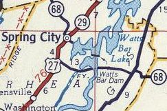
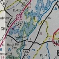
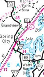
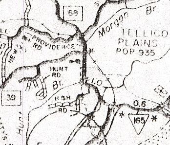
In the 1942 timeframe, the ferry over the Tennessee River had to move from north of the newly constructed Watts Bar Dam to south of it. In Meigs County TN 68 was removed in Peakland from Oak Grove Rd and Hornby Ferry Rd which is mostly underwater now west of Peak Cemetery Rd. In Rhea County, the old route is underwater west to roughly Torbett Rd/Wolf Creek Rd jct; the N-S portion of Torbett Rd; underwater again as it followed very closely the pre-dam Piney River; Park St/Hilleary St/TN 302 in Spring City. From the new ferry it headed to Spring City by connecting to US 27 nearly 3 miles south of town. I believe TN 68 was removed from Cox Valley Rd/Old Grassy Cove Rd near Crossville in the early 1950s. In 1956, TN 68 was taken off its second Tennessee River ferry and routed across Watts Bar Dam. TN 68 was removed from Peakland Rd through Akerman Crossroad; Oak Grove Rd south out of Peakland/current TN 304/Pinhook Ferry Rd; west of the river is entirely on TVA Watts Bar Nuclear Plant property, with all of the former TN 68 intact. In 1964, TN 68 was removed from the lengthy Old Hwy 68/Buck Bald Rd from the Hiawassee River to Monroe County. Also in 1964, TN 68 was removed from "Old 68 Hwy" and a TN 58 overlay. In 1966, TN 68 was removed from a brief US 11 overlay plus Walnut St in Sweetwater, which used to cross Sweetwater Creek and connect to Old Hwy 68 About 1970, TN 68 was placed on new routing bypassing Madisonville and Sweetwater. The old route used Tellico St/Warren St/College St in Madiosnville; Old Hwy 68 between the cities; Monroe St out of Sweetwater (cut off by I-75) and Richeson Rd. By 1978, TN 68 was removed from Underwood Dr through Farner; also Lake Rd (no longer connects to)/Wirt Rd south of Tellico Plains. About 1980, TN 68 was rebuilt across McMinn County into Meigs County leaving behind Tilley Rd; Nazarene Church Rd; Frazers Grocery Rd; "Old 68 Loop"; Thompson Bivens Rd and Clearwater Rd (which later became TN 305 for a time) Also about 1980, TN 68 was removed from Old Grandview Hwy in northwest Rhea County; Coal Creek Rd; both "Old Hwy 68" segments at Alloway In 1989, TN 68 was given its bypass of central Spring City leaving behind US 27 and Piccadilly Ave
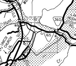
About 1990, TN 68 received its bypass of Tellico Plains, leaving behind Scott St, Veterans Mem Dr and a bit of TN 165; also TN 68 was removed from Bank St/Tate Mill Rd north of Tellico Plains; also Old State Rd/Countryside Ln through Mt Vernon; also Old Tellico Highway south of Madisonville
Between 1983-91, TN 68 was removed from Main St/Vine St in Ducktown. Posting: Posted as primary throughout The overlay with US 27 is fully posted Secret US Route Overlay: None Comment: TN 68 passes through a large swath of Cherokee National Forest; serves the Lost Sea cave attraction | Previous TN 68's:
|
TN 68 #1: An original state highway which in 1924 ran from TN 1 (now Donelson Dr/Sullivan St jct) Kingsport north to the Virginia line above Morrison City.
In 1927 or 1928, TN 68 was renumbered as part of TN 36. Today this is Donelson Dr/Truxton Dr; TN 36 through Lyon Gardens; Echo Ave, Tenneva Pl (cutoff by US 23 freeway), Tenneva St (which no longer connects back to US 23 at the state line)
| ||||||||||||||||