< unnumbered | Home | WV 2 >
| WV 1 not currently assigned | ||||||
| Previous WV 1's: 1926 ROUTE LOG Ohio State Line: 0 - 0 WV 32: 0.5 - 0.5 WV 2 NB: 2 blocks - 0.5 WV 2 SB: 0.5 - 1 WV 31: 23 - 24 WV 59: 13 - 37 WV 16: 2 - 39 WV 74: 6 - 45 WV 18 NB: 13 - 58 WV 18 SB: 6 - 64 WV 4 NB: 21 - 85 WV 4 SB: 2 - 87 WV 22: 1 - 88 WV 77: 4 - 92 WV 6: 10 - 102 WV 56: 6 - 108 WV 26: 16 - 124 WV 72: 10 - 134 Maryland State Line: 14 - 148 GAP IN ROUTE Maryland State Line: 0 - 148 WV 44: 7 - 155 WV 45: 7 - 162 WV 46: 8 - 170 WV 28: 13 - 183 WV 54: 7 - 190 WV 9: 12 - 202 Virginia State Line: 15 - 217 |
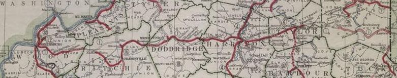
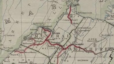
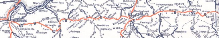
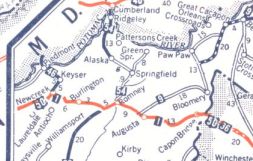
WV 1: An original 1922 state highway that entered Parkersburg from Ohio, then headed east through Clarksburg and Grafton before entering Maryland. WV 1 then re-entered from Maryland a short distance later to continue east through Romney and entering Virginia near Capon Bridge.
In 1926, WV 1 was removed from today's CR 36 from Greenwood through Duckworth and Central Station; CR 11 and CR 11/8 (no longer goes all the way to West Union). Instead WV 1 was placed on today's CR 50/30. Also in 1926, WV 1 was placed on current US 50 east of Gormania, leaving behind a long-abandoned routing well to the north of where it crosses Difficult Run In late 1926, WV 1 was replaced by US 50 except from Nutter Farm to Pike, which was apparently removed from the state highway system (later it did become part of US 50 but today it is CR 50/34) and Pike to Ellenboro which became an extended WV 16.
The approximate routing of WV 1 today: all of WV 618 EB except it used Northwestern Pike across Worthington Creek which no longer connects to CR 50/23 Old Worthington Pike; Northwestern Ave; abandoned routing that uses a touch of Core Rd west of I-77 (was CR 50/25); US 50; CR 50/38 Old US 50 except: CR 50/34, CR 50/27, CR 50/28 Red Peak Cir; CR 50/37 Murphytown Rd except: Abandoned loop over Left Stillwell Fork (was CR 50/29), CR 50/30, CR 50/20, CR 50/22 Morton Rd; abandoned routing north of Stillwell Creek; CR 50/9 and CR 50/31 through Dallison; US 50; CR 50/32 (not 50/40), a bit of WV 31, abandoned cutoff, CR 50/41 Deerwalk Rd which no longer connects to SR 5/10 and CR 5 Volcano Rd; US 50; CR 50/42 which becomes CR 50/32 in Ritchie County; CR 50/69 Sand Hill Rd; US 50; CR 50/46 which no longer connects to CR 50/33 which no longer connects to CR 50/36 to Nutter Farm; CR 50/34 except abandoned alignment which always stayed west of Goose Creek; WV 16 from Pike to Ellenboro; CR 50/39 Lamberton Rd to Pennsboro; WV 74; CR 50/40; CR 50/43 which becomes CR 50/30 in Doddridge County; CR 50/30 through Greenwood (except CR 36 Duckworth Rd which no longer connects with CR 50/31) and south and east back around as Sunnyside Rd to US 50, then northeast on CR 50/30 to West Union. WV 1 used Main St through West Union. WV 1 followed CR 50/30 Smithton Rd to Avondale (except it used CR 50/47 E. Main St east of West Union), then abandoned routing to CR 50/25 and CR 50/33 in Smithburg before picking back up CR 50/30 towards Morgansville; CR 50/34; US 50 except: CR 50/35, CR 50/24, CR 50/23, CR 50/27, CR 50/29; CR 50/28 through Salem plus E Main St stub; CR 50/73; CR 23/23; US 50; CR 50/56; CR 50/57; US 50; CR 11 through Wolf Summit and Reynoldsville to Wilsonburg; CR 9; CR 9/8 Limestone Run Rd to Clarksburg; US 19 into downtown Clarksburg, then Pike St all the way through except CR 50/26 Wonderbar Rd to where it ends at I-79; abandoned loop that was CR 50/27 just east of I-79; US 50 through Bridgeport to about WV 131; CR 50/32 Airport Rd which is now cutoff by the airport and no longer connects to US 50 just past WV 76; US 50 to near Grafton; CR 50/4 Old 50 W; Yates Ave to CR 40 south to the old bridge location into Grafton; abandoned part of Baltimore Ave in Fetterman; Railroad St and Sycamore St to Main St through Grafton; Addison St; US 119 then veering west on Lincoln St to US 50; CR 50/21 Blueville Rd; US 50 all the way to the WV 72 south jct except CR 50/23 which no longer connects to CR 7 at Thornton; abandoned loop that is bisected by WV 72 north leaving US 50; US 50 to Maryland except it used CR 50/13 and the removed Cheat River Covered Bridge. Once back in West Virginia, the route used US 50 to Virginia except: abandoned loop north of the highway west of Stony River; abandoned routing plus some of Junkins Rd northeast of Mt. Storm; CR 50/11 Snowfall Dr through White Hall; abandoned loop just east of the US 220 south junction; CR 50/29 in Mechanicsburg; abandoned crossing over S. Potomac River to meet CR 8 at Bergman Run; abandoned but intact loop along Sulphur Spring Run at the west edge of Romney; Little Capacon River Access Rd and CR 50/9 Little Cacapon River Rd loop; Clara Davis Ln west of Augusta; Nozzle Dr/Hook Rd at Pleasantdale; Flintstone Loop; long abandoned routing over Hanging Rock that stays well north of US 50; | |||||
Previous: unnumbered |
Next: WV 2
Top | West Virginia Hwy Index
Home
Page last modified 30 April 2022