< US 48 | Home | US 50 ALT | US 50N >
US 150 | US 250 | US 350 |
|
|
|
| ROUTE LOG |
OH STATE LINE: 0 - 0 WV 892: 0.6 - 0.6 WV 68 SB, WV 892: 2.5 - 3.1 WV 68 NB: 2.3 - 5.4 WV 14: 1.1 - 6.5 WV 47: 1.4 - 7.9 WV 618: 1.2 - 9.1 I-77 (exit 176), WV 2: 0.6 - 9.7 WV 31 NB: 10.7 - 20.4 Ritchie-Wood Line: 3.4 - 23.8 WV 31 SB: 3.8 - 27.6 WV 16: 9.1 - 36.7 WV 74: 5.4 - 42.1 Doddridge-Ritchie Line: 2.6 - 44.7 WV 18: 8.2 - 52.9 Harrison-Doddridge Line: 10.6 - 63.5 WV 23: 1.6 - 65.1 WV 98: 9.8 - 74.9 US 19, WV 20: 2.2 - 77.1 WV 20: 2.5 - 79.6 I-79 (exit 119): 2.0 - 81.6 WV 58: 1.6 - 83.2 WV 131: 0.9 - 84.1 WV 76: 0.9 - 85.0 WV 279: 1.7 - 86.7 Taylor-Harrison Line: 0.1 - 86.8 US 250 NB: 6.0 - 92.8 US 250 SB: 1.7 - 94.5 WV 310: 2.9 - 97.4 US 119: 2.3 - 99.7 Preston-Taylor Line: 7.6 - 107.3 WV 92 NB: 2.4 - 109.7 WV 92 SB: 0.6 - 110.3 WV 26: 1.4 - 111.7 WV 72 SB: 9.5 - 121.2 WV 72 NB: 0.2 - 121.4 WV 24: 11.5 - 132.9 MD STATE LINE: 2.4 - 135.3 GAP IN ROUTE MD STATE LINE: 0 - 135.3 WV 90: 0.1 - 135.4 WV 42 SB: 7.3 - 142.7 Mineral-Grant Line: 4.6 - 147.3 WV 42 NB: 3.3 - 150.6 WV 93 SB: 4.6 - 155.2 WV 93 NB: 2.7 - 157.9 US 220 NB: 1.9 - 159.8 Hampshire-Mineral Line: 8.2 - 168.0 US 220 SB, WV 28 SB: 1.5 - 169.5 WV 28 NB: 7.1 - 176.6 WV 29 NB: 10.7 - 187.3 WV 29 SB: 4.0 - 191.3 VA STATE LINE: 10.7 - 202.0
|
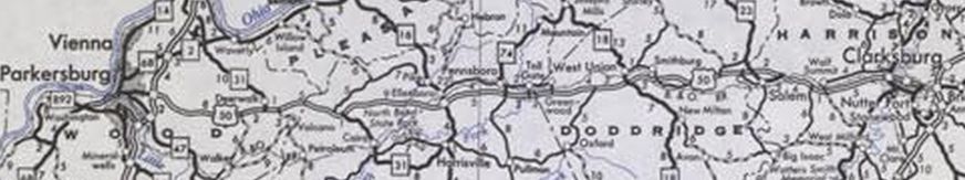
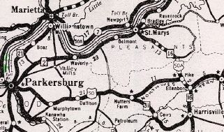
Creation: An original US Highway, running generally as it does now. This was a replacement for WV 1 everywhere except Nutter Farm to Harrisville replaced WV 31 and Harrisville to Ellenboro replaced WV 16.
|
Adjustments: In November 1928 (AASHO), US 50 from Ohio at Parkersburg to Ellensboro was redesignated as US 50S. Despite the clear directive that US 50S was the designation, West Virginia questioned in Julu 1929 whether this should remain signed as US 50 (no), and in fact the 1929 Official shows US 50N and US 50. In 1929 (bridge date), US 50 was moved from Main St to Marie St through West Union. Also in 1929 (WVDOT), US 50 was removed from CR 5026 Wonder Bar Rd east of Clarksburg as well as a now-abandoned loop that was CR 50/27 just east of I-79. Also in 1929 (WVDOH), US 50 was removed from abandoned routing plus some of Junkins Rd northeast of Mt. Storm In 1931 (WVDOH), US 50 was removed from CR 50/47 E. Main St east of West Union and placed on CR 50/30. In 1932 (bridge date), US 50 was removed from CR 50/13 and the removed Cheat River Covered Bridge In 1933 (WVDOH), US 50 was removed from Little Capacon River Access Rd and CR 50/9 Little Cacapon River Rd loop at Frenchburg; Clara Davis Ln west of Augusta; Nozzle Dr/Hook Rd at Pleasantdale; Flintstone Loop; long abandoned routing over Hanging Rock that stays well north of US 50 On January 16, 1935 (AASHO), US 50S was rerouted to end at Pike, therefore US 50 west was extended from Ellensboro over US 50N to Pike. On January 22, 1935 AASHO notified West Virginia that US 50S went back to being US 50. There was some controversy, as Ohio wanted US 50N to become US 50 and US 50S to become US 50 ALT, but AASHO ruled the other way. Note that US 50S did get reroutes that were original US 50 - CR 50/23 Old 7th St (no longer connected to) and Northwestern Pike; CR 50/25 part of Highland Ave which no longer connects back to US 50 due to I-77; CR 50/34 Nutter Farm Rd, modern US 50 and WV 31 through Cairo to Harrisville; WV 16 Harrisville to Ellensboro.
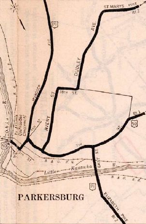
In 1935, US 50 was removed from CR 11 between Wolf Point and US 19 northwest of Clarksburg and placed on today's CR 50/39, WV 98, CR 50/40 and CR 9. The old routing became an unnumbered state route for a time plus some US 19. Also in 1935, US 50 was removed from abandoned loop north of the highway west of Stony River In 1937 (WVDOH), US 50 was removed from Old Pike Rd in Ellensboro; CR 50/43 Northwest Tpk in Toll Gate (moved to today's discontinuous CR 50/40) Also in 1937 it appears US 50 was removed from CR 50/23 which no longer connects to CR 7 at Thornton About 1938 (WVDOH), US 50 was given its bypass of central Grafton over what had briefly been designated US 50 ALT. The old route into Grafton was CR 40 south to the old bridge location into Grafton; abandoned part of Baltimore Ave in Fetterman; Railroad St and Sycamore St to Main St. Main St remained parts of US 250 (now just Main St) and US 119 (US 50 did originally use Addison Rd). Also in 1938, US 50 was removed from CR 50/21 through Blueville. Also about 1938 (WVDOH), US 50 was removed from abandoned crossing over S. Potomac River to meet CR 8 at Bergman Run; abandoned but intact loop along Sulphur Spring Run at the west edge of Romney About 1940 (bridge date), US 50 was removed from the following in Wood County: CR 50/34, CR 50/27 and CR 50/28 Red Peak Cir (moved to today's CR 50/38); Abandoned loop over Left Stillwell Fork (was CR 50/29) and CR 50/30 (placed onto current CR 50/37); CR 50/22 (placed onto today's CR 50/12 and CR 50/20) Morton Rd; abandoned routing north of Stillwell Creek; CR 50/31 through Dallison (placed onto CR 50/9); CR 50/32 through Deerwalk (placed onto today's CR 50/41) About 1949, US 50 was removed from abandoned loop just east of the US 220 south junction In the early 1950s US 50 was removed from CR 50/25 and CR 50/33 in the Smithburg area and placed on current CR 50/30. In 1955 (bridge date), US 50 was removed from CR 50/29 in Mechanicsburg In 1958 (bridge date), US 50 was removed from CR 50/4 west of Grafton. Based on historic photos, it appears US 50 received one-way splits in Parkersburg in the early-mid 1960s, with EB using Ann St/4th/Juliana/7th and WB using 7th/Ann (the original routing) In 1967 (wikipedia), the first segment of Appalachian Corridor D opened, from Sherwood to Salem. This removed US 50 from CR 50/35, CR 50/24, CR 50/23, CR 50/27, CR 50/29; CR 50/28 through Salem, E. Main St In 1969 (wikipedia), US 50 was placed on more Corridor D routing from Salem to Wolf Point, removing US 50 from CR 50/73; CR 23/23; CR 50/56; CR 50/57; CR 11 to Wolf Summit. In 1970 (wikipedia), US 50 was placed on CR 47/4 Dutch Ridge Rd south form CR 50/38 and onto new Corridor D routing around Murphytown. US 50 was removed from CR 50/38 through Murphytown. Also in 1970 (wikipedia), US 50 was placed on new Corridor D routing from WV 31 Deerwalk to Nutter Farm, removing US 50 from CR 50/41 Deerwalk Rd which no longer connects to SR 5/10 and CR 5 Volcano Rd; US 50; CR 50/42 which becomes CR 50/32 in Ritchie County; CR 50/69 Sand Hill Rd; US 50; CR 50/46 which no longer connects to CR 50/33 which no longer connects to CR 50/36 to Nutter Farm Also in 1970 (wikipedia), US 50 was placed on more new Corridor D from WV 74 Pennboro to CR 50/30 southwest of West Union. This removed US 50 from CR 50/40; CR 50/43 which becomes CR 50/30 in Doddridge County; CR 50/30 through Greenwood (except CR 36 Duckworth Rd which no longer connects with CR 50/31) and south and east back around as Sunnyside Rd In 1971 (wikipedia), US 50 was placed on new Corridor D routing from I-77 to CR 47/4. US 50 was removed from CR 50/38 and CR 47/4. Also in 1971 (wikipedia), US 50 was placed on new Corridor D routing from Murphytown to Deerwalk. US 50 was removed from CR 50/36; CR 50/9 and CR 50/31 through Dallison; CR 50/32 (not 50/40) Also in 1971 (wikipedia), US 50 was placed on new Corridor D routing from Nutter Farm to WV 74 Pennboro. US 50 was removed from CR 50/34 except abandoned alignment which always stayed west of Goose Creek; WV 16 from Pike to Ellenboro; CR 50/39 Lamberton Rd to Pennsboro; WV 74 Also in 1971 (wikipedia), US 50 was placed on new Corridor D routing from southwest of West Union to Salem. US 50 was removed from the lengthy CR 50/30. In the 1970s, US 50 was removed from CR 50/32 Airport Rd which is now cutoff by the airport and no longer connects to US 50 just past WV 76. In 1974 (wikipedia), US 50 was placed on new Corridor D routing from Wolf Summit to Wilsonburg, leaving behind more CR 11; CR 50/39, WV 98, CR 50/40 and CR 50/39.
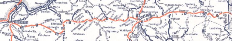
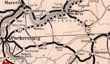
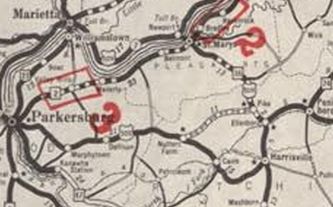
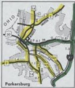
US 50 on Corridor D 1980 Official Also in 1974, US 50 WB in Parkersburg moved to 8th.
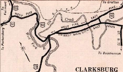
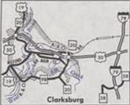
In 1977 (wikipedia), US 50 was placed on new Corridor D routing on the freeway through Clarksburg. The eastermost bit of this went back to the 1950s but I don't believe US 50 used it. US 50 was removed from 28th St; US 19 and the one-way WV 20 splits (note that US 50 was on one-way splits in Clarksburg from the beginning). In 1978 (wikipedia), US 50 was placed on new Corridor D alignment from Clarksburg to I-79. US 50 was removed from E Pike St.
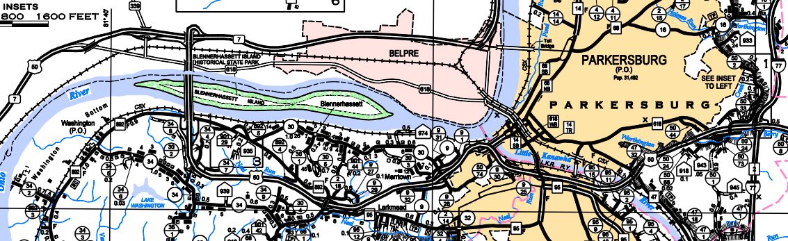
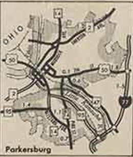
Between 1966-75, US 50 was removed from CR 50/11 Snowfall Dr through White Hall In August 2007 (AASHTO), US 50 was placed on newly constructed freeway to bypass Parkersburg and Belpre OH. The old route through Parkersburg became WV 618.
US 50 Bypasses Parkersburg 2014 Wood County Improvements: Fully paved upon inception except: WV 26 to WV 72; Mt Storm to Hartmonsville In 1929, US 50 was paved from WV 26 to WV 72. In 1930, US 50 was paved from Mt. Storm to Hartmonsville. US 50's multilaning is all associated with Corridor D routings. Comment: US 50 is a major route west of Clarksburg. Right now it is still faster to use US 50 to Clarksburg from say Moorefiled than to use US 48 to I-79. This may not remain true once Corridor H (US 48) is fully finished. | ||||||||||||||||
Previous: US 48 |
Next: US 50 ALT | US 50N
Top | West Virginia Hwy Index
Home
Page last modified 2 May 2022