< WV 60 | Home | WV 61 ALT | WV 61E | WV 61N | WV 61 Spur | WV 62 >
|
|
|
| ROUTE LOG |
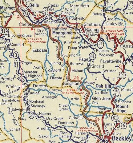
WV 41: 0 - 0 Fayette-Raleigh Line: 3.3 - 3.3 WV 16 SB: 1.1 - 4.4 WV 61 ALT: 0.3 - 4.7 WV 211: 0.4 - 5.1 US 19 SB: 4.7 - 9.8 US 19 NB: 0.6 - 10.4 WV 16 NB: 0.4 - 10.8 WV 6: 23.4 - 34.2 Kanawha-Fayette Line: 0.5 - 34.7 WV 61N: 11.4 - 46.1 WV 94: 4.9 - 51.0 I-64, I-77 (exit 95): 5.0 - 56.0 US 119 SPUR: 5.7 - 61.7 US 60: 1.5 - 63.2
|
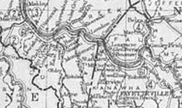
Creation: WV 61 was designated in 1922 as new primary routing, running from WV 2 (now WV 94) Marmet to WV 4 (now CR 13) Kanawha Falls. This is the only WV 61.
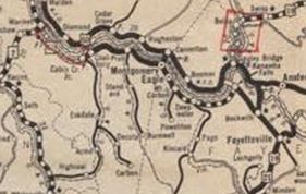
| Adjustments: In 1925 (WVDOT annual report), WV 61 was extended southeast replacing WV 4 from Kanawha Falls to end at the new US 19-21 (now WV 16) in Beckwith. Between 1929-31, if WV 61 ever used CR 61/1 Bradford Rd and former CR 61/2 (now I-64/77 ROW) from Marmet to Chesapeake (using 120th/Venable/121st) or CR 61/3 James River Rd in Chelyan it stopped doing so. About 1936, WV 61 east was rerouted at Deepwater to instead head southeast replacing CR 1 and CR 13 to end at US 19-21 (now WV 16) Oak Hill. The old route to Beckwith became CR 13. Between 1938-46, WV 61 was given its current routing around Pratt. The old route used Chesapeake/12th/Kanawha/14th/Virginia/Pratt/Center Sts. In 1946, WV 61 was extended south with US 21 to Mount Hope, then as part new construction plus upgrade to Fayette CR 19/7 and Raleigh 41/3 to end at US 19 (now WV 41).
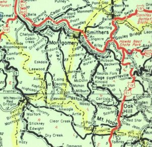
About 1950, WV 61 was placed on new routing between today's CR 77/1 Lewiston and CR 77/2 Chelyan to make room for the WV Turnpike which uses WV 61's old footprint. CR 77/2 Slaughters Creek Dr north of the Turnpike survives as old WV 61. About 1955, WV 61 was placed on the Mount Hope Bypass leaving behind WV 16 (now WV 211) and WV 61 ALT. Between 1950-56, WV 61 was extended northwest with US 119 then replaced WV 14 to end at US 60. Between 1956-59, WV 61 was placed on newly constructed McCorkle Ave leaving behind Ferry St which used to continue along wha tis now I-64's ROW to nearly US 60. In 1969, WV 61 through Montgomery was removed from CR 61/11 Fayette Pike; Monroe St; 3rd Ave; abandoned crossing of RR at WV 6's ROW. Improvements: By 1923, WV 61 was paved from Cabin Creek to Hansford In 1924, WV 61 was paved from Handley to Montgomery By 1931, WV 61 was paved from Hansford to Handley; Kanawha Falls to Beckwith By 1933, WV 61 was paved from Marmet to Cabin Creek; Montgomery to Mt. Carbon The 1936 reroute to Oak Hill was paved from Deepwater to Kincaid at that time and was paved to Oak Hill by 1946. The first segment of WV 61 to be multilaned was the newly constructed part of McCorkle (bypassing Ferry Rd), between 1956-59. The current US 19 overlay in Oak Hill may have been multilaned as early as 1961. By 1966, WV 61 was multilaned through Kanawha City By 1973, WV 61 was multilaned between those two segments above. Comment: WV 61 closely parallels either the US 19 expressway or the West Virginia Turnpike for huge portions, making this a route not used as a through route very much. | |||||||||
Previous: WV 60 | Next: WV 61 ALT | WV 61E | WV 61N | WV 61 Spur | WV 62
Top | West Virginia Hwy Index
Home
Page last modified 19 February 2018