< I-64 | Home | I-68 >
I-66N | I-266
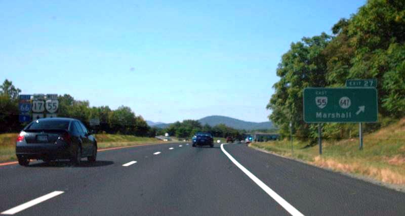
Photo: I-66 WB at Exit 27. Note the state-named shield at the far left (Mapmikey 9-3-07)
|
|
|
| ROUTE LOG |
EXIT 1 - I-81 (exit 300): 0 - 0 EXIT 6 (old 2) - US 340, US 522: 6.61 - 6.61 EXIT 13 (old 3) - VA 79: 6.49 - 13.10 Fauquier-Warren Line: 1.56 - 14.66 EXIT 18 (old 4) - SR 688: 3.96 - 18.62 EXIT 23 (old 5) - US 17 NB, VA 55 WB: 5.21 - 23.83 EXIT 27 (old 6) - US 17 Bus, VA 55 EB: 3.36 - 27.19 EXIT 28 (old 7) - US 17 SB, US 17 Bus: 1.34 - 28.53 EXIT 31 (old 8) - VA 245: 3.02 - 31.55 Prince William-Fauquier Line: 5.04 - 36.55 EXIT 40 (old 9) - US 15: 3.61 - 40.16 EXIT 43 (old 10) - US 29: 2.48 - 42.64 EXIT 44 - VA 234 SB: 2.17 - 44.81 EXIT 47 (old 11) - VA 234 NB, VA 234 Bus: 2.27 - 47.08 Fairfax-Prince william Line: 1.83 - 48.91 EXIT 52 (old 12) - US 29: 2.94 - 51.85 EXIT 53 (old 13) - VA 28: 1.25 - 53.10 EXIT 55 (old 14) - VA 286: 1.86 - 54.96 EXIT 57 (old 15) - US 50: 2.57 - 57.53 EXIT 60 (old 16) - VA 123: 1.85 - 59.38 EXIT 62 (old 17) - VA 243: 2.13 - 61.51 EXIT 64 (old 18) - I-495 (exit 49): 3.23 - 64.74 EXIT 66 (old 19) - VA 7: 1.46 - 66.20 [WB only] EXIT 67 (old 20) - VA 267: 0.82 - 67.02 Arlington-Fairfax Line: 0.86 - 67.88 [EB only] EXIT 68 (old 21) - Westmoreland Rd: 0.24 - 68.12 EXIT 69 (old 22) - US 29, VA 237: 0.94 - 69.06 EXIT 71 (old 23) - VA 120, VA 237: 1.74 - 70.80 [EB only] EXIT 72 (old 24) - US 29: 1.53 - 72.33 EXIT 73 (old 25) - US 29: 1.05 - 73.38 EXIT 75 (old 26) - US 50 WB, VA 110, GW PKWY: 0.85 - 74.23 DC LINE: 0.50 - 74.73
|
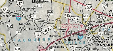
Creation: I-66 was an original interstate corridor in Virginia. Note that there are 1950s CTB references to I-66 from in the Arlington and Gainesville areas as being VA 405. The first official map to show anything was unlabeled dotted lines on the 1961 issue. Per Scott Kozel's website, the first segment to open was from US 29 Gainesville to US 29 Centreville, in Dec 1961.
| Adjustments: In March 1962 (Kozel), I-66 was opened from the VA 55/SR 729 vicinity to VA 17-55 west of Marshall. In June 1964 (Kozel), I-66 was opened from US 29-211 Rosslyn across the Theodore Roosevelt Bridge. In Nov 1964 (Kozel), I-66 was opened from US 29 Centreville to I-495.
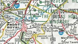
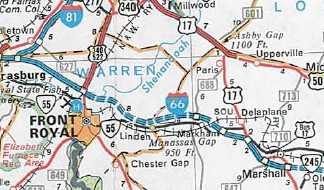
In Oct 1971 (Kozel), I-66 was opened from I-81 to US 340-522. In Feb 1974, the CTB adopted a modified multi-modal/new facility for the completion of I-66 inside the beltway. This was in response to a 4th Circuit Court ruling in April 1972 to have an EIS performed along with public hearings. The multi-modal transit most notably included the Vienna Metro Line. Essentially VDOT was being sued to prevent completion of the route - full details can be found a Scott Kozel's website. In July 1976, the CTB adopted a 4-lane proposal for the completion of I-66 from I-495 to Rosslyn, in conjunction with additional transit elements. This was in response to the original I-66 proposal being rejected by the USDOT. In Oct 1977 (Kozel), the Marshall piece was extended west 1.3 miles. In June 1978 (Kozel), the Marshall piece was extended east to today's US 17 Bus/VA 55/SR 647 exit.
In Aug 1979 (Kozel), I-66 opened from US 340-522 to the Marshall piece; also from SR 647 to the US 17/17 Bus exit at Marshall. In Dec 1979 (Kozel), I-66 opened from US 17 Marshall to US 15 Haymarket. In Dec 1980 (Kozel), I-66 opened from US 15 Haymarket to US 29 Gainesville. 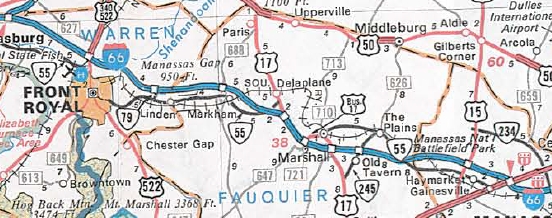
I-66 completed west of I-495 1980 Official In Dec 1982 (Kozel), I-66 opened from I-495 to US 29 Rosslyn. 
I-66 completed east of I-495 1982 Official Improvements: I-66 opened as 4-lanes everywhere except US 50 to I-495 which was built as a 6-lane segment. In 1982, the completed I-66 east of I-495 was configured such that all lanes were HOV-3 during the respective rush hours inbound and outbound. Exceptions existed for Dulles Airport travelers using the Dulles Access Road and I-66 east of there. In 1993 (Kozel), a shoulder lane was added in each direction for use during the respective rush hours between US 50 and I-495. The innermost lane in each direction became HOV-2. In March 1995 (Kozel), the HOV-3 inside the beltway was reduced to HOV-2. In 1997 (Kozel), I-66 was widened to 8-lanes from VA 234 Business Manassas to US 50. The innermost lane each way became HOV-2. In 2006, I-66 was widened to 8-lanes from VA 234 Bypass to VA 234 Business. Again the innermost lane became HOV-2. Around 2010, I-66 was widened to 8-lanes from VA 234 Bypass west to US 29 Gainesville, with the inner lane becoming HOV-2. In 2011, the HOV-only exits at Stringfellow Rd and Monument Dr were opened to all traffic outside of Eastbound HOV hours. In 2016, I-66 was widened to 8-lanes from US 29 Gainesville to US 15 Haymarket. The innermost lane is a HOV-2 extension. In December 2017, all lanes of I-66 between I-495 and Rosslyn were converted to HOoT lanes during the rush hour (EB in the morning and WB during the afternoon). In September 2022, 2-lanes in each direction were converted into HOoT lanes from US 29 Gainesville to VA 28 Centreville. The new configuration became 3-2-2-3 with this conversion. In November 2022, 2-lanes in each direction were converted into HOoT lanes from VA 28 Centreville to I-495. The new configuration became 3-2-2-3 with this conversion. With the new I-66 express lanes, some interchanges were rebuilt: VA 28; VA 123; I-495 New Exits Added: VA 286 (1988) (WB HOV only) SR 645 Stringfellow Rd (1997) (WB HOV only) SR 7969 Monument Dr (1997) Posted: Fully posted; A few state-named shields remain, sprinkled throughout. One for sure remains on I-66 itself, out in the Marshall area. Multiplexes: US 17, VA 55 (3.36 mi) US 17 (1.34 mi) VA 234 (2.27 mi) US 50 (0.50 mi) Legislative names: Custis Memorial Parkway, I-495 to DC (since 1-21-82); Other names: None Scenic Byway: No segments HOot Lane Exits:
Comments: VDOT wants to widen I-66 inside the beltway but so far has only committed to doing spot widenings on transition lanes. The right-of-way already exists for an 8-lane freeway to the Rosslyn Tunnel and 6-lanes could be done from there to the TR Bridge. Evidently Congress in 1999 overruled the court decisions of the early 1970s that prevented a larger freeway, but VDOT did technically promise Arlington it wouldn't widen I-66 as a concession to building it at all. I-66 is prohibited for trucks east of I-495 at all times. There is no specific posted I-66 TRUCK route. On technicality trucks might be allowed to use I-66 between US 29 Rosslyn and VA 110. Traffic on I-66 is frequently epic. I think the now-removed shoulder lanes caused problems - tons of wrecks occured on 66 westbound before VA 243 Nutley St. West of Marshall I-66 begins to get into some mountains and can be scenic. I-66 totally blows off VA 55 (near Delaplane), VA 55 (near The Plains), and VA 124. Proposals to extend I-66 all the way out to Kansas have been put out there, following US 48 and Corridor H from I-66's current end. Only Kentucky seems materially interested and may convert some of their east-west parkways into a western I-66 segment. | |||||||||||
Previous: I-64 |
Next: I-68
I-66N | I-266
Top | Virginia Hwy Index
Home
Page last modified 26 November 2022
