< I-68 | Home | I-74 >

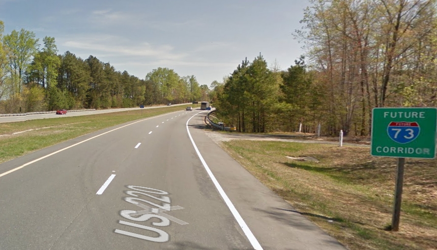
Photo: I-73 corridor on US 220 north just inside Virginia (April 2014 GMSV)
| I-73 Santa's not coming...go back to bed | |||
|
I-73: Some information below comes from the aaroads.com interstate guide.
The I-73 corridor was first created by the Intermodal Surface Transportation Efficiency Act of 1991 (ISTEA). I-73 was supposed to run from Sault Ste. Marie MI to Charleston SC (since truncated to Myrtle Beach). The first action in Virginia on I-73 was a feasibility study intiated in Dec 1993 (VDOT). In March 1994 (CTB), the route of I-73 corridor in Virginia was defined to be US 460 Glen Lyn to Blacksburg; the Smart Road to I-81; I-81 to Roanoke; I-581 through Roanoke; US 220 to Martinsville to North Carolina at Ridgeway. Additionally the CTB directed that the Commissioner of VDOT communicate with West Virginia authorities to tie into the King Coal Highway, while the CTB Chairman was to discuss with Virginia's congressional delegation for funding. In July 1996 (AASHTO), the general corridor of I-73 from Roanoke south to North Carolina was approved, following US 220 and I-581. In 1996, the CTB undertook 4 years worth of environmental studies on the approved I-73 corridor, with FHWA approval occurring in Oct 2000. In May 2001, the CTB officially decided to build I-73 with the following description of the route: The board selected a location that overlaps I-581 in Roanoke to Elm Avenue, then veers to the southeast and enters Franklin County near Coopers Cove, travels east of Rocky Mount into Henry County and stays east of Martinsville, before turning slightly and entering North Carolina southwest of Ridgeway. In June 2001 (CTB), I-73's route in southern Franklin County and Henry County was shifted eastward and would no longer use any portion of the US 58 Bypass of Martinsville. In July 2004 (CTB), part of I-73 was officially rerouted to avoid Southeast Roanoke Neighborhood which was put on the Historic Places Registration. Originally I-73 left I-581 around VA 24 and headed southeast to cross Windy Gap Mountain. With this change, I-73 would follow US 220 to about Crowell Gap Rd before veering southeast - here is the July 2004 I-73 corridor map Per VDOT, in April 2007, the FHWA issued a Record of Decision on I-73 in Virginia, clearing the way for designing the highway. In Dec 2009, the CTB directed that studies be undertaken to shift I-73 westward in the Martinsville area. In June 2011 the CTB approved pursuit of shifting I-73's routing westward in the Martinsville area based on the results of studies performed since 2009. The latest route approval for I-73 from Roanoke to North Carolina: Dec 2012 I-73 corridor map. In Nov 2014 (VDOT), the Virginia Joint Committee on Interstate 73 met for the first time. They were tasked with presenting a plan for moving forward with I-73 in Jan 2016. Part of this involves strategizing with other I-73 states to try to secure federal funding. However, as of later in 2016 this Committee was allowed to legislatively expire. In fall 2021, the final EIS was released for the Martinsville Southern Connector, a freeway that would bypass existing US 220 to the west of Ridgeway and connect to the US 58-220 bypass. I-73 would almost certainly be placed on that should this get built. In Sept 2024, the CTB rescinded all approvals for I-73. This was forced by a new policy that approvals require a 3-year review that requires cancelling if no money has been identified to move the project forward. There is not much practical effect from this happening. EIS approvals were already old enough that starting over was going to be the next step anyway. At this point, North Carolina and South Carolina are further along in the I-73 business. North Carolina has built many miles of freeway and has a significant I-73 segment from the Haw River well north of Greensboro south Rockingham. West Virginia is building its King Coal Hwy along US 52 but only to expressway standards and not interstate. Ohio and Michigan have no interest in I-73 at this point.
|
|||
Previous: I-68 |
Next: I-74
Top | Virginia Hwy Index
Home
Page last modified 18 February 2025