< US 29 | Home | US 33E >
US 33 Business
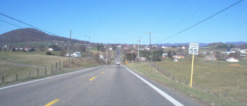
Photo: US 33 westbound in the Dale Enterprise area west of Harrisonburg (photo by Mapmikey 3/18/06)
|
|
|
| ROUTE LOG |
US 250 EB: 0 - 0 VA 399: 1.02 - 1.02 VA 399: 0.05 - 1.07 VA 161: 0.23 - 1.30 VA 197: 0.97 - 2.27 US 250 WB: 0.79 - 3.06 Henrico-Richmond Line: 0.03 - 3.09 I-64 (exit 185): 1.32 - 4.41 VA 356: 1.01 - 5.42 VA 157: 4.70 - 10.12 I-295 (exit 49): 0.61 - 10.73 Hanover-Henrico Line: 0.38 - 11.21 VA 54: 11.42 - 22.63 Louisa-Hanover Line: 5.89 - 28.52 US 522 SB: 12.00 - 40.52 US 522 NB: 0.66 - 41.18 VA 22 EB, VA 208 EB: 6.56 - 47.74 VA 208 WB: 0.40 - 48.14 VA 22 WB: 4.92 - 53.06 US 15 SB: 8.28 - 61.34 Orange-Louisa Line: 0.45 - 61.79 US 15 NB, VA 231 SB: 1.12 - 62.91 VA 231 NB: 0.15 - 63.06 VA 20 SB: 5.45 - 68.51 VA 20 NB: 0.22 - 68.73 Greene-Orange Line: 4.51 - 73.24 US 29: 2.24 - 75.48 US 33 Bus: 4.74 - 80.22 US 33 Bus: 2.09 - 82.31 Skyline Drive: 7.38 - 89.69 Rockingham-Greene Line: 0 - 89.69 US 33 Bus, US 340: 6.25 - 95.94 US 33 Bus: 1.62 - 97.56 VA 276: 10.71 - 108.27 Harrisonburg-Rockingham Line: 2.29 - 110.56 I-81 (exit 247): 1.66 - 112.22 US 11 NB: 1.59 - 113.81 US 11 SB: 0.10 - 113.91 VA 42: 0.08 - 113.99 Rockingham-Harrisonburg Line: 1.72 - 115.71 WV STATE LINE: 19.16 - 134.87
|
Creation: US 33 appeared in Virginia in Sept 1937 as a renumbering of VA 4 from Richmond to the west Virginia Line. This was at least the 4th attempt to get a US 33 into the US route system, and the 3rd to involve Virginia. Per an Oct 18, 1937 memo, US 33 ended at US 1.
|
Adjustments: In Feb 1939 (CTB), US 33 was removed from SR 701 in Dale Enterprise. In Apr 1940 (CTB), US 33 was removed from SR 709 in Farrington. In Aug 1941 (CTB), US 33 was removed from SR 678 through Barboursville In May 1943 (CTB), US 33 was given its current corridor from Gordonsville to Trevillians as an upgrade to SR 649. Half of this distance was taken into the primary system in Sept 1942 (CTB) with no number specified, although the 1943 VDOT County Atlas labels that stub off US 15 as US 33. The old route from Trevillians to Boswells Tavern became an extended VA 22 and US 15 remained from Boswells Tavern to Gordonsville. In April 1944 (CTB), US 33 was given its current routing from Louisa to Cuckoo as a replacement for VA 248. The old route became more VA 22 from Louisa to Mineral and US 522 remained from Mineral to Cuckoo.
In 1944 or 1945, US 33 was straightened out between US 15 and VA 22, removing a number of railroad crossings. I am guessing that when US 60 was significantly changed in Nov 1953 (CTB), US 33 east was extended from US 1 to US 60's departure from Broad St at 11th. In Jan 1960 (CTB), US 33 was removed from Old Route 33/Hungary Rd/Old Staples Mill Rd in the Laurel area of Henrico County. About 1960, US 33 was removed from Country Club Rd in eastern Harrisonburg. In Feb 1967 (CTB), US 33 was removed from the lengthy SR 981 west of Elkton. In Dec 1967 (CTB), US 33 was removed from the lengthy SR 996 and SR 997 in Montevideo and McGaheysville. In Nov 1969 (CTB), US 33 was placed on its expressway bypass south of Elkton, leaving behind US 33 Busniess. Between 1960-69, US 33 was extended east to US 360 although it was posted to become VA 33 at 25th and Broad (VA 5). It is unclear where the US 33-VA 33 transition was for many years. See my US 33-VA 33 transition page which lays out all the evidence I have on where this has been over the years. In March 1973 (CTB), the unbuilt Stanardsville Bypass was placed into the Primary System. In Dec 1981 (CTB), US 33 east was truncated to its current endpoint at the new location of VA 33 utilizing Hancock and Harrison Sts leaving Broad St. Broad St east to US 360 remained US 250. Note the Dec 1981 CTB specifically puts the previous US 33 endpoint at US 360, 17th St. This may have been true since June 1974 when US 60 was removed from Broad St west of 21st. The reroute was clearly intended to end US 33 at Broad and Hancock/Harrison, but AASHTO butchered the description on its end which is how the center of VA 33's ML King Bridge over I-95 may have become the posted endpoint and Leigh at Hancock/Harrison became somehow the endpoint.  US 33 re-route request, clearly indicating US 33 ends at Broad and Harrison/Hancock September 9, 1981 AASHTO Application About 2000, US 33 was given its Stanardsville Bypass, leaving behind US 33 Business.
About 2014, US 33 was removed from SR 829 in Montpelier. Improvements: US 33 has always been fully paved in Virginia. The first multilaning of US 33 occurred by 1954, on Broad St out to Staples Mill Rd, then over to Dickens Rd on Staples Mill In 1957, US 33 was multilaned out to today's Old Staples Mill Rd. In 1962, US 33 was multilaned in the I-81 area of Harrisonburg. In 1964, US 33 was multilaned east from I-81 area to today's west SR 996 jct. In 1968, US 33 was multilaned from the west SR 996 jct to the east SR 981 jct. In 1971, US 33 was widened from SR 981 east to the base of the ascent to Skyline Drive. In 1988, US 33 was multilaned from VA 157 to the Hanover line. In 1991, US 33 was multilaned from VA 157 south to Hungary Rd. In 1992, US 33 was widened from Old Staples Mill to hungary Rd. In 1993 or 1994, US 33 was widened from US 29 to the east end of Stanardsville Bypass About 2000, US 33 was multilaned on the Stanardsville Bypass and west to SR 810. There are climbing lanes over the mountain on both sides. Posted: Fully posted; As of spring 2010 there are still a few cutouts in Gordonsville, Harrisonburg, and also at SR 842 near Montevideo; Richmond cutouts removed in mid-2000s. Error VA 33 shield on I-64 at Staples Mill Rd exit; longtime error VA 33 shield on WB Broad at Staples Mill was removed in early 2000s. US 33 is also erroneously signed on the Broad St exit from I-95. Multiplexes: US 250 (3.06 mi) US 522 (0.66 mi) VA 22, VA 208 (0.40 mi) VA 22 (4.92 mi) US 15 (1.57 m) VA 231 (0.15 mi) VA 20 (0.22 mi) US 11 (0.10 mi) Legislative names: The Jefferson Hwy, Richmond to Cuckoo (3/9/22 designation predates US 33); Spotswood Trail, Gordonsville to Harrisonburg except bypasses (2/26/24 designation predates US 33) Veterans of Foreign Wars Bridge over I-81 (5/19/94); George Ward Dalton Bridge over railroad in Lee County (4/8/98); Other names: Broad St (Richmond); Staples Mill Rd (Henrico Co); Mountain Rd (Hanover Co); Main St (Louisa); Louisa Rd (VA 22 duplex); Martinsburg Ave (Gordonsville); Market St (Harrisonburg); Rawley Pike (w of Harrisonburg) Scenic Byway: No segments Comments: There has been some occasional confusion about US 33's eastern endpoint, even within VDOT logs. The route log explicitly states the endpoint as the intersection of Broad St (US 250) and Harrison St, while VDOT's traffic log notes the endpoint as the intersection of Hancock St and Leigh St (4 blocks NE of US 250 and 4 blocks NW of US 1/301). The city of Richmond is in charge of signage within their city, and they apparently do not place a high priority on signage, so the signs in the field are of little help in determining the endpoint. When I first explored Richmond in the mid-80s, the route was posted as US 33 from the center of the MLK Bridge west and VA 33 from that point east. So I actually thought the transition point was on the bridge. Today, Hancock/Harrison are still posted US 33 but Leigh has some VA 33 shields. The Sept 1981 CTB moved VA 33 off 25th and placed Leigh and hancock/Harrison into the primary system but labeled its sheet "US and primary state route 33" when listing segments of those streets. But because US 33 was not moved until 3 months later, and the Sept 1981 action placed Harrison/Hancock into the primary system, US 33 must therefore end at Broad St and not Leigh. US 33 is a rustic route from Richmond to Elkton, with little traffic. Below Louisa it is also full of 40 mph curves. West of Harrisonburg is quite scenic and the serious mountain curves begin right at the WV border. US 33 is shown as VA 33 on the 1944 Official Map Richmond inset. Dave also reports seeing a 1939 map with US 33 shown all the way to Reedville, but no other maps he or I have seen corroborate this. However, the reverse-side historical peninsula maps of the 1951 and 1952 Official Maps do show VA 33 as US 33 in the Saluda area. Like US 360, US 33 should have been extended to the Bay or at least to US 17. | Previous US 33's:
|
US 33 #1: Appeared in a May 9, 1933 letter from AASHO to Virginia responding to correspondence on changing around and adding some US routes in Virginia. AASHO suggested US 33 be assigned to run from Reedville to US 311 Rocky Mount via Richmond, Burkesville, Keysville and Brookneal.
On May 12, 1933 Virginia formally requested US 33 be assigned to run Reedville to Rocky Mount. Reedville to Richmond would replace VA 13; Richmond to Burkeville would be a replacement for part of US 60; Burkeville to Keysville would be a replacement for part of US 501; Keysville to Rocky Mount would replace VA 20. On May 15, 1933 Virginia followed up in a letter to AASHO to reroute US 33 at Keysville to instead replace US 501 to Halifax and replace VA 12 to Danville. Note Virginia had been planning to extend US 221 from Roanoke to Reedville via Burkeville and Richmond. Also on May 15, 1933 AASHO approved the US 33 corridor but the Committee was spilt on allowing US 33 to be the designation because it was pretty far out of the grid. AASHO suggested US 360 and on May 16, 1933 Virginia formally accepted US 360 for the route. US 33 #2: Virginia was asked by Kentucky (their State Highway Commission passed a resolution for this route in Nov 1930!) to support their wish to route a new US route from Harlan KY through Pennington Gap, Jonesville and Blackwater to Tennessee as part of a corridor from Chicago to Charleston SC. The earliest reference of Virginia's involvement is a Sept 2, 1933 letter to State Senator Lloyd Robinette from the Virginia Highway Commission affirming that Virginia was happy to advocate for this. On March 8, 1934 Virginia requested US 33 be added to the US route system through Virginia as described above. KY to Pennington Gap would've replaced some of VA 65; Pennington Gap to TN would've replaced some of VA 64. On Dec 20, 1934 AASHO denied the addition of US 33 on the basis that the Kentucky portion of the route was not constructed. A parallel (though apparently non-coordinated) effort was being made by Tennessee to have a US 33 corridor from Chicago to Charleston, but they formally requested US 33E and US 33W routings through their state and their proposal had US 33W running on the same path as this US 33 #2 in Virginia. | |||||||||||||
Previous: US 29 |
Next: US 33E
Top | Virginia Hwy Index
Home
Page last modified 18 February 2025