|
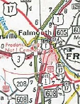
From:   New Post (Spotsylvania County) New Post (Spotsylvania County)
To:
 Falmouth(Stafford County) Falmouth(Stafford County)
Total Length: 8.71 miles
|
|
|
|
|
ROUTE LOG
US 17, VA 2 SB: 0 - 0
Fredericksburg-Spotsylvania Line: 4.53 - 4.53
VA 3: 0.55 - 5.08
US 1 Bus SB: 0.32 - 5.40
VA 2 END, VA 3 Bus: 0.44 - 5.84
US 1 SB, US 1 Bus END: 0.76 - 6.60
Stafford-Fredericksburg Line: 0.11 - 6.71
US 1 NB, VA 218: 0.35 - 7.06
I-95 (exit 133), US 17: 1.65 - 8.71
|
|
Creation: Appeared Nov 1969 when US 17 was placed on a new bypass around the west side of Fredericksburg and Falmouth. This is the 2nd US 17 Business.
Adjustments: The routing of US 17 Business was changed in the field to use Charles St from Dixon to US 1 Bus Lafayette. The old route slightly east is no longer numbered. This change has not been reflected in AASHTO or CTB as far as I can tell.
It is unclear as this writing whether the one-way splits already existed when US 17 Business was created.
Improvements: Paved upon inception; Multilane on US 1 duplex and from US 1 to I-95 in Stafford County, since inception.
Posted: Fully posted outside the City of Fredericksburg; Not posted at all on the US 1 Bus duplex and from the NB direction there is no indication 17 Business should follow 1 Business.
Multiplexes: VA 2 (5.40 mi)
US 1 Bus, VA 2 (0.44 mi)
US 1 Bus (0.76 mi)
US 1 (0.46 mi)
Legislative names: Washington-Rochambeau Route, Falmouth to New Post (since 2/20/75); Historyland Highways, Fredericksburg to New Post (5/26/53 designation predates US 17 Bus), Tidewater Trail, Fredericksburg to New Post (2/26/58 designation predates US 17 Bus)
Other names: Dixon St/Lafayette Blvd; Princess Anne St (SB); Sophia St (NB); Warrenton Rd (Falmouth)
Scenic Byway: no segments
Comment: This US 17 Business could easily be eliminated in favor of VA 2 and an extended VA 218.
Up until the early-2000s there was a posted US 17 TRUCK associated with this business route (and might go back to before mainline 17 was moved to I-95) that followed US 1, VA 3 Business and Kenmore Ave.
|
 |
|
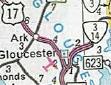
From: near Gloucester (Gloucester County)
To:
 near Gloucester (Gloucester County) near Gloucester (Gloucester County)
Total Length: 2.47 miles
|
|
|
|
|
ROUTE LOG
US 17: 0 - 0
VA 3, VA 14 SB: 1.20 - 1.20
US 17, VA 14 NB: 1.27 - 2.47
|
|
Creation: Appeared in June 1973 (AASHO) when US 17 was placed on the newly completed bypass around the west side of Gloucester. This is the 3rd US 17 Business.
Adjustments: None
Improvements: Paved upon inception; Multilane from VA 3-14 southwardsince inception.
Posted: Fully posted; an error VA 17 Bus shield existed in 2008 NB at VA 3-14.
Multiplexes: VA 14 (1.27 mi)
Legislative names: George Washington Memorial Hwy, entire route (designation 2/27/24 predates US 17 Bus); Historyland Highways, entire route (5/26/53 designation predates US 17 Bus), Tidewater Trail, entire route (2/26/58 designation predates US 17 Bus)
Other names: Main St
Scenic Byway: no segments
Comment: US 17 Business navigates a traffic square in the oldest part of Gloucester.
|
 |
|
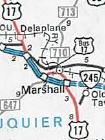
From:  Marshall (Fauquier County) Marshall (Fauquier County)
To:
 Marshall(Fauquier County) Marshall(Fauquier County)
Total Length: 1.56 miles
|
|
|
|
|
ROUTE LOG
I-66 (exit 28), US 17: 0 - 0
VA 55 EB: 0.71 - 0.71
I-66 (exit 27), US 17, VA 55 EB: 0.85 - 1.56
|
|
Creation: Appeared in June 1978 (AASHO) when US 17 was placed on I-66 around the south side of Marshall. This is the 4th US 17 Business.
Adjustments: None
Improvements: Paved upon inception; no multilane segments
Posted: Fully posted; an odd "17/55" in a white rectangle exists west of SR 710.
Multiplexes: VA 55 (0.85 mi)
Legislative names: John Marshall Hwy, F185 to VA 55 EB split (designation 9/7/33 predates US 17 Bus)
Other names: Winchester Rd, Main St, Free State Rd
Scenic Byway: F185 to VA 55 EB split (since 9/19/96)
Comment: US 17 Business between F-185 and I-66 was never part of mainline US 17 but was instead SR 721 before I-66 came along.
|
 |
|
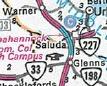
From:  Saluda (Middlesex County) Saluda (Middlesex County)
To:
Saluda (Middlesex County)
Total Length: 1.63 miles
|
|
|
|
|
ROUTE LOG
US 17, VA 33 WB: 0 - 0
VA 33 EB: 0.80 - 0.80
US 17: 0.83 - 1.63
|
|
Creation: Appeared about 1986 when US 17 was placed on a bypass around the west side of Saluda. This is the 5th US 17 Business.
Adjustments: None
Improvements: Paved upon inception; no multilane segments
Posted: Fully posted; In the 1990s there was a VA 17 shield SB approaching the end of the route.
Multiplexes: VA 33 (0.80 mi)
Legislative names: None
Other names: Gloucester Rd and School Rd
Scenic Byway: no segments
Comment: Not a lot going on with this 17 Business segment.
|
 |
|
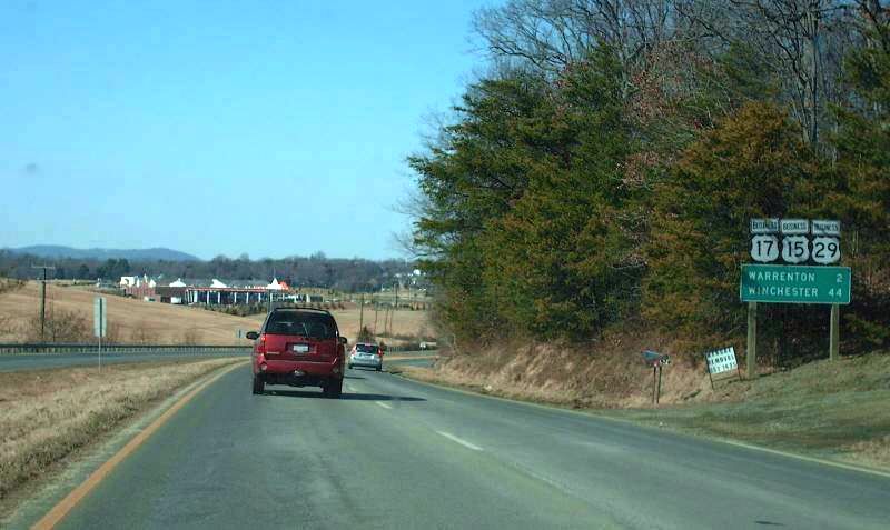
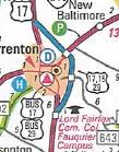
From:   near Warrenton (Fauquier County) near Warrenton (Fauquier County)
To:
Warrenton (Fauquier County)
Total Length: 4.23 miles
|
|
|
|
|
ROUTE LOG
US 15, US 15 Begin, US 17, US 29, US 29 Begin: 0 - 0
US 15 Bus NB: 0.89 - 0.89
US 211 WB, US 211 Bus: 1.76 - 2.65
US 29 Bus NB, US 211 EB: 0.86 - 3.51
US 17: 0.72 - 4.23
|
|
Creation: Appeared about 1998 when US 17 was placed on a bypass around the east and north side of Warrenton. This is the 6th US 17 Business.
Adjustments: None
Improvements: Paved upon inception; Multilane everywhere except between SR 802 down to US 15 Bus (which is 3-laned)
Posted: Fully posted; Error VA 17 Business shields appeared in 2008-09 NB at US 15 Bus and SB at SR 802.
Multiplexes: US 15 Bus, US 29 Bus (0.89 mi)
US 29 Bus (1.76 mi)
US 29 Bus, US 211 (0.86 mi)
Legislative names: Seminole Trail, US 29 Bus duplex (designation 2/16/28 predates US 17 Bus); James Madison Hwy, entire route (3/19/28 designation predates US 17 Bus)
Other names: Shirley Ave and Broadview Ave
Scenic Byway: no segments
Comment: The section between US 15 Bus split and old VA 29 (SR 802) is the original 1930s layout of the original Warrenton Bypass.
|
 |
| | | | |