< VA 326 | Home | VA 328 >
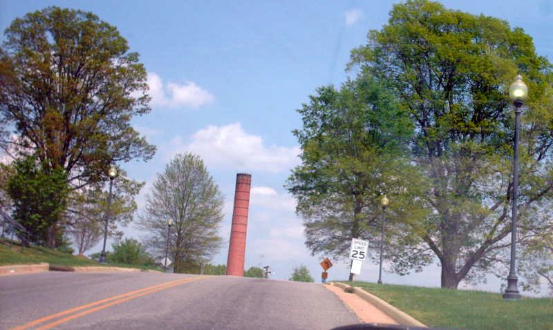
Photo: VA 327 leaving VA 36 (photo by Mapmikey, April 2007)
| ||||||
|
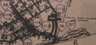
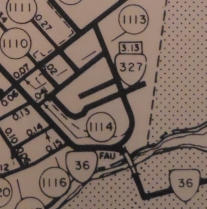
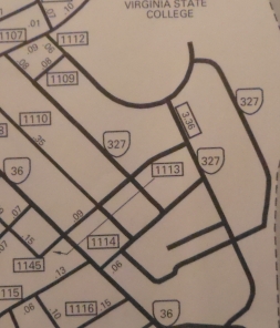
Creation: The Virginia State College for Negroes received 1.59
miles of state mileage in 1932. This received a number around 1938.
This is the 3rd VA 327.
Adjustments: In May 1959 (CTB), the following additions were made to VA 327: 5th Ave from SR 1113 southeast (0.12 mi); College Ave from SR 1114 to SR 1113 (0.10 mi); North of Foster Hall from College Ave southwest (0.04 mi); west of Foster Hall from SR 1113 southeast (0.06 mi); Heat Plant Rd from College Ave northeast (0.04 mi); Hayden St out to SR 1114 (0.09 mi); Barnes St from College Ave east to and around Owens Hall (0.41 mi). This was a total of 0.86 additional miles onto VA 327. In April 1965 (CTB), the following additions were made to VA 327: SR 1110 from SR 1114 northwest (0.05 mi); SR 1111 from SR 1114 northwest (0.10 mi); SR 1112 from SR 1113 to SR 1109 (0.27 mi); SR 1113 from SR 1110 northeast (0.45 mi); SR 1114 from 0.04 miles east of VA 36 to VA 327 (0.23 mi); SR 1121 from SR 1113 northwest (0.05 mi). This was a total of 1.15 additional miles onto VA 327.
Posting: Did not see any kind of markings on VA 36 in October 2001; I visited the campus in April 2007 -- I did not see any 327 postings anywhere. Comment: VA 327 does not appear on any official maps. VA 327 has 3 main endpoints - VA 36, SR 1102 and SR 1107. Ettrick is right across the river from Downtown Petersburg | ||||||
| Previous VA 327's: 1926 ROUTE LOG VA 32: 0 - 0 END VA 327: 7 - 7 GAP IN ROUTE Fauquier-Stafford Line: 0 - 7 VA 31: 12 - 19 1933 ROUTE LOG VA 306: 0 - 0 US 60, VA 10: 0.20 - 0.20 |
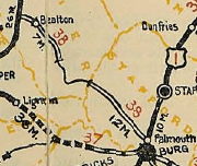
VA 327 #1: Created in January 1925, in two pieces: 1. VA 32 (curr US 15-29) Opal southeast for 3 miles. 2. VA 31 (curr SR 607) Falmouth northwest for 4 miles over CR 6.
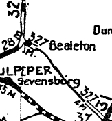
In May 1926, VA 327 was extended 8.4 miles towards Bealton and 5 miles towards Falmouth. In October 1926 VDOT Route Log shows 327 becoming VA 314 then both sections became part of the original VA 38. Today it is part of the US 17 corridor. Stafford and Fauquier County have a bunch of SR loops that constitute much of what original VA 327 followed.
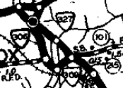
VA 327 #2: Created in June 1932 (CTB Minutes) as an unidentified new primary route. The 1932 VDOT County Atlas shows VA 327 running as a tiny route on Church St from VA 309 (current VA 131) to US 60/VA 10 (current US 460 Business) within Appomattox. In July 1933 this became part of VA 26. Today it is SR 727. VA 327 was the highest 3xx route in the 1928-33 system.
|
|||||
Previous: VA 326 |
Next: VA 328
Top | Virginia Hwy Index
Home
Page last modified 28 May 2020