< VA 333 | Home | VA 335 >
| |||||
| ROUTE LOG VA 210: 0 - 0 SR 1013: 2.08 - 2.08 |
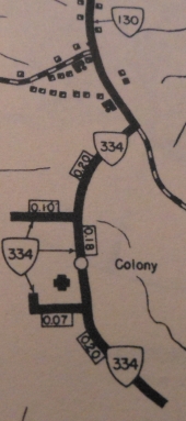
Creation: The State Colony for Epileptics and Feeble-Minded
received 0.85 miles of state mileage in 1932 but did not receive a
number until at least 1938. Appears on VDOT maps since 1944. Initially
ran only on the facility property, connecting to VA 130. This should be
the 2nd VA 334.
Adjustments: In January 1966 (CTB) VA 334 underwent numerous additions/deletions: 10 unidentified segments totaling 2.12 miles were added to VA 334, while 5 unidentified segments totaling 0.75 miles were removed from VA 334. This gave VA 334 a net gain of 1.37 miles. In 2005, VA 334 was extended out of the facility to meet the rerouted VA 210. This replaced a piece of VA 210. Posting: Full shields at VA 210 plus one at its original north end; white rectangles throughout the facility. Comment: VA 334 is fully drivable within the facility. There are other roads in the facility posted as SR 1xxx routes. Note that VA 311 #2 was not part of VA 334s inital routing as VA 311 only led to the facility. This facility closed in 2020. The site is slated to become available as commercial development but there are still bonds to be paid off related to the facility and there are nearly 100 buildings, many with asbestos and other hazards, that would need to be remediated in some way. So VA 334 may stick around a few more years...
|
||||
| Previous VA 334's: 1926 ROUTE LOG BEGIN VA 334: 0 - 0 VA 33 NB: 4 - 4 VA 33 SB: 1 - 5 END VA 334: 9 - 14 |
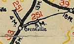
VA 334 #1: Created in March 1924 as an upgrade to CR 14. Ran
from VA 33 (curr US 11) near Greenville westward to 2 miles short of
Middlebrook.
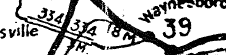
In January 1925 (CTB), VA 334 developed a brief VA 33 duplex south, then was extended 5 miles east over CR 15 towards Stuarts Draft. In May 1926 (CTB), VA 334 was extended 4 more miles east towards Waynesboro. It appears right after this VA 334 east of VA 33 became VA 396 (now mostly US 340). However it is less clear if VA 334 west of VA 33 also became VA 396, as 334 was also in the Oct 1926 route log as "see 251" which strongly implies 334 was still around (other routes decommissioned prior to this time were not listed in the log pointing you to their replacements). I have yet to find a map showing VA 396 on it. If 334 remained west of VA 33, it became VA 251 in Oct 1926. Today this is part of SR 701.
|
||||
Previous: VA 333 |
Next: VA 335
Top | Virginia Hwy Index
Home
Page last modified 26 March 2022