< VA 392 | Home | VA 394 >
|
|
|
| ROUTE LOG |
VA 234: 0 - 0 END VA 393: 0.63 - 0.63
|
Creation: The campus opened in 1972. This is the 2nd VA 393.
| Adjustments: It is unclear if VA 393 originally ended at the circle or if it has always continued around to the backside of campus as it does now. Improvements: Paved upon inception; no multilane segments Posting: A white rectangle used to up at VA 234 but was removed in the late 90s. Multiplexes: None Legislative names: None Other names: None Scenic Byway: No segments Comments: The segment between VA 234 and the traffic circle is one-way eastbound (into campus) since the late 90s. VA 393 does not appear on official maps although there is room in the inset for it. | Previous VA 393's:
1925 ROUTE LOG US 60, VA 39: 0 - 0 END VA 393: 23 - 23 GAP IN ROUTE Pamunkey River: 0 - 23 VA 30: 0.5 - 23.5 |
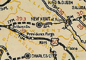
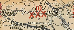
VA 393 #1: Appeared March 1923 (CTB) running from VA 39 (now US 60) Bottoms Bridge east to New Kent C.H. It is unclear if this was a renumbering of part of VA 9 SPUR #2.
In July 1924 (CTB), VA 393 was assigned to a separate piece running along 14th St from VA 30 in West Point to the Pamunkey River. This is confirmed in the 1926 Route log. In May 1926 (CTB), VA 393 was extended from New Kent C.H. east 2 miles.
In March 1927 (CTB), VA 393 was extended east 4 more miles towards West Point, ending a little east of the VA 30-33-249 jct. In Aug 1928, VA 393 was renumbered as VA 415.
Today, VA 393 is abnadoned alignment from US 60 at the Henrico County Line; then VA 249 except: SR 611 Quaker Rd and (no longer connects to) Holly Hill Rd in Quinton; SR 627 Stage Rd/abandoned SR 678 east of New Kent CH; SR 626 Paige Rd Slaterville; SR 623 Pamunkey Church Rd |
|||||||||||


