< VA 414 | Home | VA 416 >
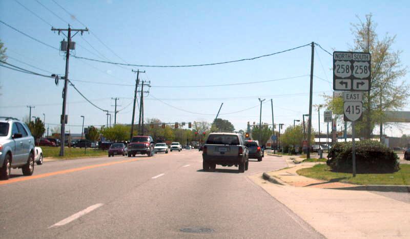
Photo: Approaching the VA 415 start point at US 258 (photo by Mapmikey, 4/20/07)
| ||||||
| ROUTE LOG US 258: 0 - 0 VA 351: 2.59 - 2.59 |
Creation: Appeared in Aug 1981 (CTB) as upgraded routing. Ran essentially as it does today. This is the 3rd VA 415.
Adjustments: Not long after 2001, VA 415 was placed on the new Power Plant Pkwy, leaving behind a segment of W. Queen St near US 258. Improvements: Paved and multilaned upon inception Posting: Fully posted at VA 351; Until 2019 or so it posted from VA 152 as TO VA 415. However, the run from Power Plant Pkwy to Queen St turn is not posted in either direction. Multiplexes: None Legislative names: None Other names: power Plant Pkwy; Queen St, Settlers Landing Rd Scenic Byway: None Comment: VA 415 is blown off by I-664. |

1986 Official |
||||
| Previous VA 415's:
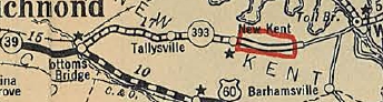
1932 ROUTE LOG US 60, VA 39: 0 - 0 VA 440: 7 - 7 VA 413: 3 - 10 VA 53: 13 - 23 VA 30: 2 - 25 |
VA 415 #1: Appeared in August 1928 as a renumbering of VA 393
from US 60/VA 39 Bottoms Bridge (right at the Henrico-New Kent Line)
past New Kent CH to about Angelview Church, then east as new routing 3
miles to the existing Pamunkey River Bridge, then replacing a separate
piece of VA 393 on 14th St in West Point, ending at VA 30.
About 1930, VA 415 was rebuilt and removed from today's SR 611 Quaker Rd and (no longer connects to) Holly Hill Rd in Quinton; SR 627 Stage Rd/abandoned SR 678 east of New Kent CH; SR 626 Paige Rd Slaterville; SR 623 Pamunkey Church Rd In July 1933, VA 415 was renumbered as part of VA 4.
 VA 4 replaces VA 415 1933 Official VA 415 violated the numbering scheme when it crossed the Pamunkey River from District 4 to District 6. This is odd because VA 53 was assigned to today's VA 30/273 to cross the District 5-District 4 line at Barhamsville and thus should have been the designation into West Point. However, the 1931 Route log says 53 ends at 415 and 415 ends in West Point. |
|||||

Previous: VA 414 |
Next: VA 416
Top | Virginia Hwy Index
Home
Page last modified 15 February 2025