< SC 44 | Home | SC 46 >
|
|
|
| ROUTE LOG |
US 15, US 176: 0 - 0 SC 310: 3.6 - 3.6 SC 453: 4.3 - 7.9 SC 6 WB: 0.8 - 8.7 Berkeley-Orangeburg Line: 6.2 - 14.9 SC 6 EB: 4.7 - 19.6 US 52: 18.7 - 38.3 US 17 ALT SB: 14.8 - 53.1 US 17 ALT NB, SC 41: 3.8 - 56.9 Charleston-Berkeley Line: 13.5 - 70.4 US 17: 6.5 - 76.9
|
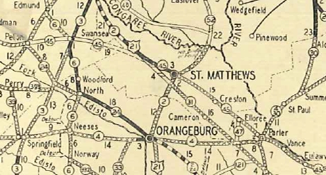
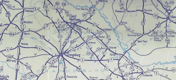
Creation: SC 45 appeared in 1923 as new primary routing, running from SC 31 (now US601/SC 6 jct) St. Matthews east to SC 41 (now S-8-27) St. Stephen. This is the only SC 45.
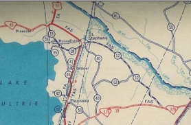
| Adjustments: About 1925, SC 45 east was truncated to the new SC 41 (now US 52) location near Pineville. The road to St. Stephen is almost certainly today's Brewington Rd, Karakul Ln, S-8-186 Imperial Dr, and S-8-64 Roosevelt Dr.
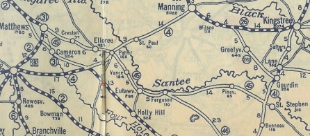
In 1929, SC 45 was extended west replacing SC 31 through St Matthews, then after a brief overlay with Us 21/SC 2 (now US 176), SC 45 extended west as new primary routing through Swansea and ending at SC 24 (now US 178) Pelion. In July 1936 (SCDOT), SC 45 was extended east with US 52 into St Stephen, then further southeast as new primary routing to end at SC 179 (now Spring Pond Rd) west of Jamestown. In 1939, SC 45 west was rerouted at Eutawville to instead head west as new primary routing to end at US 15-176 Wells. The old route became SC 6 west to Swansea and SC 69 (now S-32-9 and S-32-246) from Swansea to Pelion.
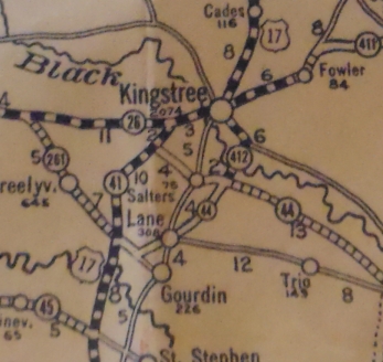
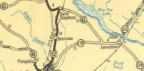
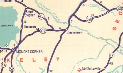
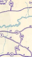
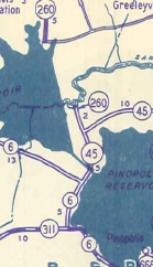
In 1942, Lake Marion required SC 45 to be rerouted. It followed SC 6 much further east out of Eutawville to Cross, then north replacing SC 260 to Eadytown where it rejoined the existing SC 45 east to St Stephen. The parts of old SC 45 that did not go underwater are today's S-38-137 and a little of S-8-31. In 1947, SC 45 east was truncated to US 52 west of St Stephen. St Stephen to the Jamestown area became S-8-12. In 1949, SC 45 east was re-extended back to SC 179 (now US 17 ALT) near Jamestown.
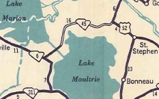
In 1950, SC 45 was rerouted at Cross onto newly constructed road to the Diversion Canal bridge. The old route remained part of SC 6 plus S-8-132. In 1951, SC 45 was given a newly built bypass of Eadytown and was also put on newly constructed road between Pineville and St. Stephen. The route through Eadytown is now S-8-23 and S-8-31, while the old Pineville to US 52 connection is S-8-6. Also in 1951, SC 45 was extended east with US 17 ALT to Jamestown, the southeast replacing S-8-4, S-10-10, and S-10-11 (was once SC 179) to US 17-701 McClellanville.
In the late 1990s, SC 45 was reconfigured to eliminate a 1-block overlay with US 52 in St Stephen. Improvements: The first piece of SC 45 to be paved was between SC 2 (current US 176) and St. Matthews in 1930. SC 45 was paved on the US 52 multiplex in 1937. SC 45 was paved between Elloree and Santee in 1938 In 1939, SC 45 was only paved between Wells and Eutawville (other paved segments were no longer SC 45). In 1949, SC 45 was paved from Eutawville east to the Berkeley County Line and also from St. Stephen to Jamestown. In 1950, SC 45 was paved from the Orangeburg-Berkeley Line to the new Diversion Canal Bridge. The remainder of SC 45 was paved in 1951. SC 45 has no multilane segments. Comment: SC 45 serves northern Berkeley County, hugging just south of the Santee River swamp. SC 45 also serves Francis Marion's Tomb (The Swamp Fox). | ||||||||||||||||
Previous: SC 44 |
Next: SC 46
Top | South Carolina Hwy Index
Home
Page last modified 22 January 2016