< TN 55 | Home | TN 56A | TN 57 >
|
|
|
|
| ROUTE LOG |
AL STATE LINE: 0 - 0 US 41 ALT NB, TN 15 WB: 16.6 - 16.6 TN 156: 2.5 - 19.1 Grundy-Franklin Line: 1.3 - 20.4 Marion-Grundy Line: 0.1 - 20.5 I-24 (exit 134), US 64: 1.8 - 22.3 US 41 NB, TN 2 NB, TN 15 END: 0.4 - 22.7 TN 2 SB: 0.8 - 23.5 Grundy-Marion Line: 0.1 - 23.6 US 41 SB, TN 150: 5.4 - 29.0 TN 108: 10.0 - 39.0 TN 50, TN 108 SB: 4.6 - 43.6 TN 108 NB: 0.1 - 43.7 Warren-Grundy Line: 13.7 - 57.4 TN 127: 10.6 - 68.0 TN 8: 0.6 - 68.6 TN 55 Bus SB, TN 108 SB: 1.7 - 70.3 TN 55 Bus END, TN 108 END, TN 380: 0.1 - 70.4 US 70S, TN 1: 1.4 - 71.8 TN 287: 10.0 - 81.8 DeKalb-Warren Line: 1.5 - 83.3 TN 288: 2.9 - 86.2 US 70, TN 26: 4.9 - 91.1 TN 83: 1.7 - 92.8 Putnam-Dekalb Line: 10.7 - 103.5 I-40 WB (exit 273), TN 141: 0.6 - 104.1 I-40 EB (exit 280): 6.6 - 110.7 US 70N, TN 24: 2.3 - 113.0 TN 291: 1.7 - 114.7 Jackson-Putnam Line: 1.5 - 116.2 TN 290 WB: 0.9 - 117.1 TN 290 EB: 1.3 - 118.4 TN 53 SB: 8.7 - 127.1 TN 53 NB, TN 85 EB, TN 135 SB: 1.2 - 128.3 TN 85 WB: 4.0 - 132.3 TN 135 NB: 2.6 - 134.9 TN 151: 6.0 - 140.9 Macon-Jackson Line: 3.7 - 144.6 TN 262 EB: 2.7 - 147.3 TN 80, TN 262 WB: 2.4 - 149.7 TN 52: 5.3 - 155.0 TN 151: 1.2 - 156.2 KY STATE LINE: 8.5 - 164.7
|
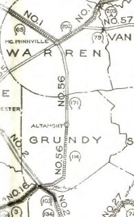
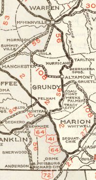
Creation: Appeared in 1923 as an original state highway, running from TN 2 Monteagle to TN 1 (now TN 380) McMinnville.
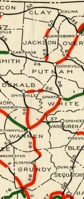
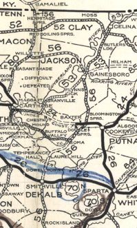
| Adjustments: In 1925 or 1926, TN 56 was extended north as new routing to TN 26 (now Main St) Smithville. In 1927 or 1928, TN 56 was extended north as new routing to the Baxter area, then replaced TN 53 to Gainesboro, then west and north as new routing through Red Boiling Springs and into Kentucky. In 1931 or 1932, TN 56 south was extended west with TN 15 to Sewanee, then south as new routing to the Alabama line.
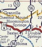
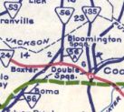
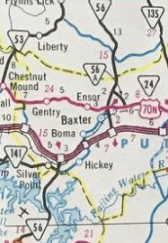
In 1934, TN 56 was removed from Scott Rd north of Steppsville; Byars Rd well east of McMinnville; Old Beersheba Rd east of McMinnville In 1936, TN 56 was removed from Jake Summers Rd which used to connect back to TN 56 at Ford Spring Rd jct north of Sherwood. Between 1939-47, TN 56 was removed from Maple St in Sewanee. In 1940, TN 56 was removed from Albert Knight Rd north of Beersheba Springs; removed from Wanamaker Ln at the Warren/Grundy Line In 1941, TN 56 was placed onto Main St into McMinnville. The old route used Bridge St to S. Chancery St. Between 1941-47, TN 56 was removed from Missouri Ave/Airport Rd/TN 156/Midway Rd east out of Sewanee. Northeast of Otter Falls Rd is abandoned. In 1949, TN 56 got its bridge over Caney Fork Lake. The old route used Loves Ferry (Floating Mill Rd north of the lake and Baron Bluff Rd south of the lake). I'm guessing about 1950 TN 53-56 was removed from Murray St in Gainesboro, which used to connect to TN 53-56 at the north end of Birch St. In 1953, TN 56 was placed on newly constructed alignment from McMinnville to just short of DeKalb County line. The old route is N. Chancery St/Old Smithville Rd/Este Griffith Rd/Mitchell Rd; abandoned route e of TN 56; Mike Muncy Rd; abandoned route w of 56/Bessie Gribble Rd Between 1957-59, TN 56 was rerouted at Baxter to avoid Double Springs, leaving behind US 70N and TN 56A (now TN 291). In 1960, TN 56 was removed from Cronover Rd/abandoned Crow Creek crossing/now a driveway at Anderson near the Alabama line. Also about 1960, TN 56 was removed from Fisher Rd at today's I-40 Exit 276. By 1963, TN 56 was removed from Carthage Rd/Main St loop in south Red Boiling Springs and McClure St in Red Boiling Springs In 1963, TN 56 was removed from McCoinsville Rd through McCoinsville and School Dr south of Gainesboro In 1964, TN 56 was removed from Old State Hwy 56 in Cumberland Heights. In the mid-1970s, TN 56 was removed from the looping University Ave in Sewanee; also removed from Old State Rt 56 in Coalmont In 1966, TN 56 was removed from Magnolia Ln south of Smithville In 1968, TN 56 was moved onto I-40 (which had already opened by 1964). The old route used Old Baxter Rd, then Main St, Dunvain Dr and Old SR 56 thgough Baxter.
In the late 1960s, TN 56 was removed from Old Gainesboro Rd in Bloomington Springs as well as Bethel Park Rd just inside Jackson County; also removed from Herbert Johnson Cir/Biss Johnson Cir, Lee Fox Cir, James Stafford Rd, Hubert Brown Cir and Pap Johnson Cir north of Center Grove In 1971, TN 56 received its bypass of central Smithville, leaving behind College St and Church St. In 1972, TN 56 was removed from Main St and Hull Ave in Gainesboro. In 1974, TN 56 was moved from Main St to Colville St in McMinnville. In 1989, TN 56 was straightened out through North Springs Posting: Posted as secondary routing south of Sewanee, between TN 80 and TN 151, and north of Red Boiling Springs; posted as primary routing everywhere else. TN 56 is not posted on I-40 itself. The US 41A and US 41 overlays are also unposted. The TN 53 overlay is posted. Secret US Route Overlay: US 41 (6.3 mi) Comment: TN 56 is the major state route N-S corridor in east central Tennessee. It is puzzling that TN 56 has not been rerouted over TN 151 to Red Boiling Springs. | ||||||||||
Previous: TN 55 |
Next: TN 56A | TN 57
Top | Tennessee Hwy Index
Home
Page last modified 4 December 2020