< TN 57 | Home | TN 58A | TN 58 Spur | TN 59 >
|
|
|
| ROUTE LOG |
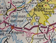
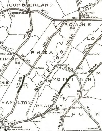
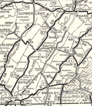
GA STATE LINE: 0 - 0 TN 17 SB: 2.15 - 2.15 TN 17 NB: 0.05 - 2.2 I-24 (exit 178), US 27: 2.2 - 4.4 US 11, US 64, TN 2, TN 27: 0.2 - 4.6 GAP IN ROUTE TN 17, TN 153: 0 - 4.6 TN 312 WB: 9.1 - 13.7 TN 312 EB: 0.6 - 14.3 TN 60: 9.9 - 24.2 Meigs-Hamilton Line: 0.1 - 24.3 TN 306: 4.5 - 28.8 TN 30: 13.3 - 42.1 TN 304: 0.4 - 42.5 TN 68: 8.7 - 51.2 Roane-Meigs Line: 8.2 - 59.4 TN 72: 7.1 - 66.5 TN 304: 2.3 - 68.8 US 70, TN 1: 3.6 - 72.4 I-40 WB (exit 352): 0.8 - 73.2 I-40 EB (exit 356), TN 326: 3.9 - 77.1 TN 327: 6.0 - 83.1 TN 95: 0.9 - 84.0
|
Creation: An original state highway, running from TN 2 (now US 11-64) Ooltewah to TN 1 (now US 70) Kingston.
| Adjustments: In 1927 or 1928, TN 58 was routed away from Ooltewah and instead sent to TN 27 (now Market St) Chattanooga. The old route used Gamble Rd/Old Hwy 58 in Meigs County and Ooltewah-Georgetown Rd in Hamilton County.
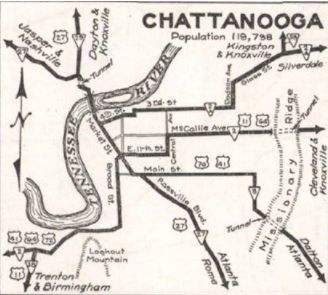
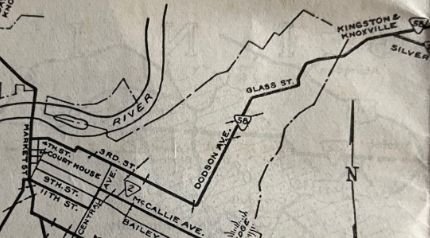
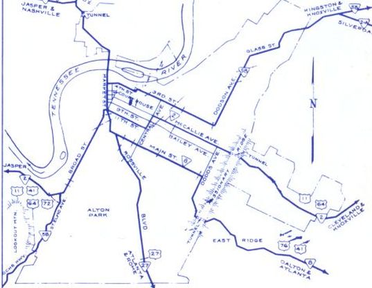
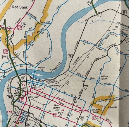
If TN 58 ever used Centerpoint Rd/Sliger Ln (no longer crosses Big Sewee Ck)/Old Ten Mile Rd north of Decatur to Roane County, it stopped doing so by 1930. In 1930, TN 58 was removed from Dodson Ave north of Glass St; Harrison Pike (now underwater north of Kings Rd until Booker T Washington State Park); Champion Rd/Harrison Pike; more underwater routing to where it meets up with current TN 58 at Hunter Rd. In 1931 or 1932, TN 58 was given its first bridge over the Tennessee River below Kingston, leaving behind a private driveway west of the river; Twin Rivers Ferry; abandoned routing east of the river that is now partly underwater plus used the footprint of Tonachio and Betty Brown Trails. By 1935, TN 58 was removed from Eastville Cir south of today's TN 306. About 1937, TN 58 south was truncated to TN 2A (now TN 317) northeast of Chattanooga. The old route became part of TN 2A Today this is 4th St to west edge of Citizens Cemetery, then north to 3rd St (this L connection is no longer a road) east, Dodson Ave north, Glass St northeast
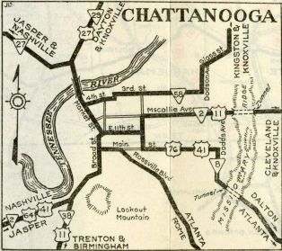
In 1941, Tennessee unsuccefully tried to get US 58 routed on TN 58 from Chattanooga to Kingston In 1941 or 1942, TN 58 was re-extended to US 27 Market St, replacing TN 2A. In 1944, AASHO turned down a TDOT request to add US 58 to the entirety of TN 58. In 1951, TN 58 was extended south on US 27 Market St in Chattanooga, then followed US 11-41-64-72 on 11th and Broad, then kept south as new state highway on St. Elmo Ave and Ochs Hwy to the Georgia line. Between 1957-59, TN 58 was rerouted in Chattanooga to stay on Market south until it became Alton Park, the west on 40th to Tennessee Ave north to Ochs Hwy southwest. In 1964, TN 58 north was extended north of Kingston to the new I-40, then east with I-40 about 4 miles, then north as new state highway to TN 95 Oak Ridge.
 TN 58 extended to TN 95 1964 Official Between 1965-68. TN 58 was paced oon one-way splits in Chattanooga between Market and Citizens Cemetary. SB used 3rd St (which had a zig-zag with Douglas St), while NB continued using 4th St
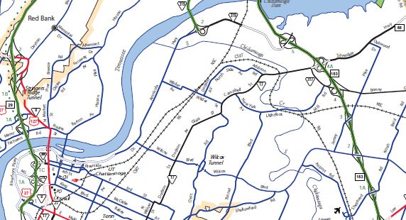
In 1973 or 1974, TN 58 was rerouted to follow TN 153 north a bit, then come down Amnicola Hwy west which becomes Riverside Pkwy. TN 58 used Riverside Pkwy all the way around until it becomes 20th St which TN 58 used to get back to Market. The old routing became part of TN 17. 3rd/4th Sts west of TN 17 were removed from the state highway system. About 1981, TN 58 was removed from Walnut Grove Rd by Meadow Lake Airport; abandoned routing plus McMurray Rd In 2002 or 2003, TN 58 was removed from 20th/Riverside Pkwy/Amnicola Hwy and TN 153. Only Amnicola Hwy between Dupont Pkwy and TN 153 remained in the state highway system (as TN 319), though some of 20th is now part of US 11-64. This created a gap in TN 58 which has no simple way to get between the segments.
Posting: Posted as secondary routing south of Chattanooga; posted as primary routing everywhere else. The overlay with I-40 is fully posted from TN 58's point of view. To be fair there are no I-40 reassurance shields between the TN 58 exits either. Secret US Route Overlay: None Comment: TN 58 can be a viable alternative to either I-75 or US 27 The Chattanooga gap in TN 58 makes no sense. They should really renumber the Lookout Mountain segment as something else. | ||||||||||||||
Previous: TN 57 |
Next: TN 58A | TN 58 Spur | TN 59
Top | Tennessee Hwy Index
Home
Page last modified 29 July 2023