< TN 65 | Home | TN 66A | TN 67 >
|
|
|
| ROUTE LOG |
US 411, US 441, TN 35, TN 71: 0 - 0 TN 448: 0.2 - 0.2 TN 338 EB: 2.5 - 2.7 TN 338 WB: 1.7 - 4.4 TN 139: 2.2 - 6.6 I-40 WB (exit 407): 2.0 - 8.6 Jefferson-Sevierville Line: 2.3 - 10.9 I-40 EB (exit 415), US 25W NB, US 70 WB, TN 9 NB: 5.6 - 16.4 TN 92 NB: 3.0 - 19.4 TN 92 SB: 0.7 - 20.1 US 25W SB, US 70 EB, TN 9 SB: 0.8 - 20.9 TN 341 SB: 8.2 - 29.1 TN 341 NB: 0.1 - 29.2 Hamblen-Jefferson Line: 2.5 - 31.7 TN 342: 0.2 - 31.9 TN 160: 1.9 - 33.8 US 11E SB, TN 34 WB: 1.4 - 35.2 TN 343: 4.5 - 39.7 US 25E SB, TN 32 SB: 2.1 - 41.8 US 25E NB, TN 32 SB: 0.2 - 42.0 TN 344: 3.6 - 45.6 TN 113: 4.2 - 49.8 Hawkins-Hamblin Line: 2.1 - 51.9 US 11E NB, TN 34 EB: 1.1 - 53.0 TN 113: 8.4 - 61.4 TN 70 SB: 0.4 - 61.8 US 11W, TN 1, TN 70 NB: 3.8 - 65.6 TN 94: 9.2 - 74.8 Hancock-Hawkins Line: 8.1 - 82.9 TN 31 SB: 6.5 - 89.4 TN 31 END, TN 33: 0.2 - 89.6
|
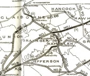
Creation: Appeared in 1923 as an original state route, running from TN 32 (Church at Main) Tazwell through Sneedville to TN 1 (now Main St) Rogersville
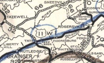
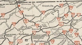
| Adjustments: About 1926, TN 66 was rerouted to end at TN 32 well south of Tazewell and connect back up with the original route a bit south of Sneedsville. Years later the old route eventually became TN 345, TN 63, and TN 33. In 1927 or 1928, TN 66 was extended south from Rogersville with TN 70 to Persia, then as new state highway to end at US 511 (now US 11E) Bulls Gap In 1940, TN 66 north was truncated to its current endpoint south of Sneedsville. The route over to US 25E/TN 32 became TN 33.
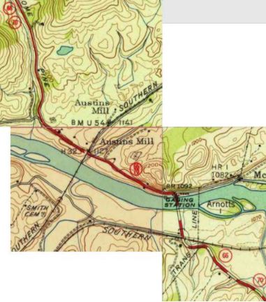
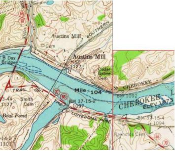
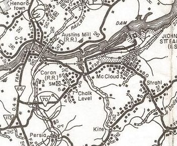
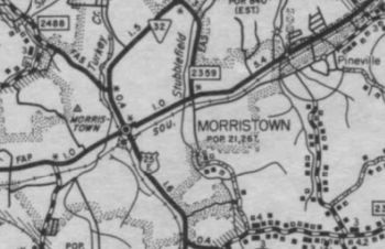
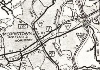
Between 1944-46, TN 66 south was extended with US 11E to Morristown, then with US 25E to White Pine, then southwest as new state highwy to US 25W-70, then with those routes to Dandridge, then southwest as more new routing to end at TN 35-71 (now US 411-441) Sevierville. In 1952 or 1953, TN 66 was rerouted at Morristown to head directly to Dandridgeas new primary routing, The road from White Pine to US 25W-70 became TN 66A (now TN 113). In 1958, TN 66 was rerouted west of McCloud to its current crossing of the Holston River as new construction. The old crossing was directly north of where today's Old Hwy 70 crosses the railroad about a mile east of current TN 66-70. TN 66 was also removed from a mile of McKinney Chapel Rd on the north side of the river as well as Big Springs Rd through Henardtown. About 1966, TN 66 was given its bypass of Rogersville leaving behind Broadway/Depot/Main St. Also about 1966, TN 66 was removed from Daisy St/E. Main St/Mornigside Dr and placed on E. 1st North St east out of Morristown About 1967, TN 66 was puy on its modern routing south of the Holston River. The 1958 bridge included a stub that extended a short distance (see second topo scan below) which was extendd further as newly constructed routing. The old routimg became Old TN 70, a rerouted TN 70 (now Old Persia Rd), and Old TN 66.
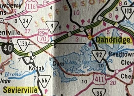
About 1975, TN 66 was rerouted to run Sevierville north to I-40 as mostly new construction, then implied concurrencies with I-40 east to US 25W-70 east back to Dandridge. The old route became Douglas Dam Rd (now TN 338 and TN 139) plus a couple blocks of TN 92.
Between 1982-85, TN 66 was moved to use Morris Blvd and a bit of US 25E through Morristown.
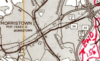
In 1995 or 1996, TN 66 was placed on TN 160 and newly constructed ML King Pkwy south of Morristown. This left behind Valley Home Rd. In 2008, TN 66 was removed from Jarnigan Ave and placed on newly built extension of ML King Pkwy In late 2020, TN 66 was placed on new multilane routing from TN 341 to TN 160, then replaced TN 474 to US 11E Morristown then east with US 11E to pickup where old 66 ran. The old route became 3 discontinuous segments of Valley Home Rd plus ML King Pkwy in Morristown Posting: Posted as secondary from Dandridge to TN 341 and from Rogersville to TN 33; posted as primary everywhere else except its overlays with I-40, US 25W-70, and US 11E are unposted. Secret US Route Overlay: none Comment: TN 66 is the major corridor from both Sevierville and Morristown to I-40. TN 66 is little changed on its rather arduous routing north of Rogersville. | |||||||||||||||||
Previous: TN 65 |
Next: TN 66A | TN 67
Top | Tennessee Hwy Index
Home
Page last modified 1 March 2024