< TN 135 | Home | TN 137 >
| ||||||
| ROUTE LOG US 70S, TN 1: 0 - 0 TN 287: 1.2 - 1.2 White-Warren Line: 0.8 - 2.0 US 70, TN 26: 11.4 - 13.4 TN 135: 4.3 - 17.7 TN 111 SB: 4.1 - 21.8 Putnam-White Line: 1.8 - 23.6 TN 111 NB: 1.5 - 25.1 I-40 (exit 287): 2.3 - 27.4 US 70N WB, TN 24 WB: 1.75 - 29.15 US 70N EB, TN 24 EB: 0.05 - 29.2 Overton-Putnam Line: 8.4 - 37.6 TN 293: 0.4 - 38.0 Putnam-Overton Line: 0 - 38.0 Overton-Putnam Line: 1.4 - 39.4 TN 85: 9.2 - 48.6 TN 292: 0.4 - 49.0 TN 52: 7.0 - 56.0 |
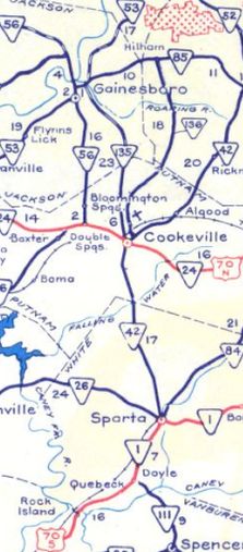
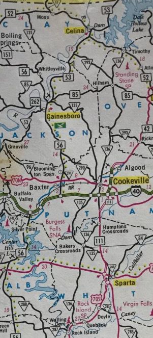
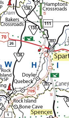
Creation: Appeared in 1949 or 1950 running from TN 42 (now E. 10th St) Cookeville to TN 85 Hilham.
Adjustments: In 1970, TN 136 was straightened out at the Roaring River crossing leaving behind completely abandoned and winding alignment. In 1973, TN 136 was straightened out at the Putnam/Overton line where it crosses Spring Creek. The route use to loop west up and around to cross the creek. The access road to Bend of the River PSA is the old alignment on the north side of the creek. In 1983, TN 136 was extended both directions - north to TN 52 Hilham; south to US 70S Rock Island In 1985, TN 136 was straightened out at the Flat Creek crossing south of Hilham, leaving behind Flat Creek Pointe Ln south of the creek. Between 1982-93, TN 136 was removed from "Old 136" north of Hardy. In 1995, TN 136 was extended south replacing US 70S through Rock Island and south to the current US 70S. Posting: Posted as secondary routing throughout The overlays with US 70N and TN 111 are both fully posted. Secret US Route Overlay: None Comment: Bookended by Rock Island State Park and Standing Stone State Park, with Cookeville roughly in the middle.
| |||||