< US 25E | Home | US 27 >
|
|
|
| ROUTE LOG |
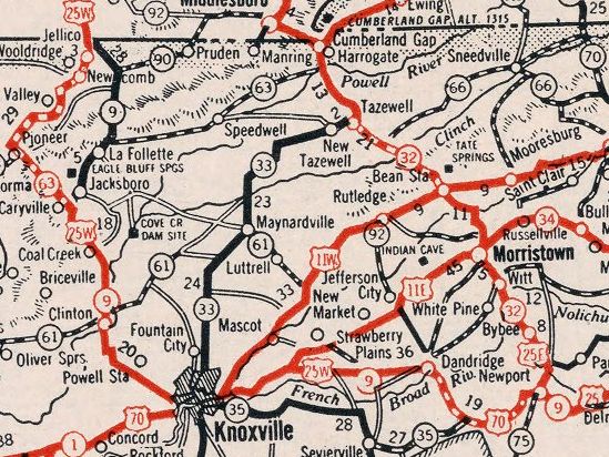
US 25, US 25E, US 70 WB, TN 9 NB, TN 32: 0 - 0 I-40 (exit 432): 2.6 - 2.6 US 411, TN 35 WB: 0.8 - 3.4 Jefferson-Cocke Line: 1.1 - 4.5 TN 363: 0 - 4.5 TN 113: 5.8 - 10.3 TN 66 NB: 3.6 - 13.9 TN 92 SB: 0.8 - 14.7 TN 92 NB: 0.7 - 15.4 I-40 (exit 415), TN 66 SB: 3.0 - 18.4 TN 139 WB: 7.9 - 26.3 Sevier-Jefferson Line: 0.4 - 26.7 TN 139 EB: 1.1 - 27.8 Knox-Sevier Line: 1.8 - 29.6 US 11E NB, TN 34: 3.8 - 33.4 TN 168 WB: 5.1 - 38.5 I-40 EB (exit 394), US 11E SB, US 70 WB, TN 168 EB: 0.9 - 39.4 I-40 WB (exit 393), I-640 Begin: 1.1 - 40.5 US 441, TN 33, TN 71: 4.6 - 45.1 I-75, I-275 (exit 3), I-640 WB (exit 3): 2.4 - 47.5 TN 131 NB: 5.5 - 53.0 TN 131 SB: 0.4 - 53.4 Anderson-Knox Line: 1.1 - 54.5 TN 170: 2.8 - 57.3 TN 61: 4.5 - 61.8 TN 116 SB: 9.7 - 71.5 US 441, TN 71: 0.5 - 72.0 I-75 SB (exit 129), TN 116 NB: 0.4 - 72.4 Campbell-Anderson Line: 0.8 - 73.2 I-75 NB (exit 134), TN 63 WB: 4.9 - 78.1 TN 116: 0.2 - 78.3 TN 63 EB: 8.3 - 86.6 TN 90: 16.2 - 102.8 I-75 (exit 160): 6.5 - 109.3 TN 297: 1.0 - 110.3 KY STATE LINE: 0.3 - 110.6
|
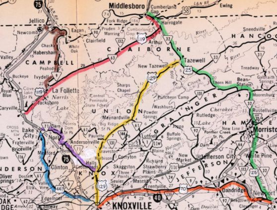
Creation: First mapped by Tennessee in November 1927 as a replacement of US 25 and addition to
TN 9 from Knoxville (Western at Broadway) through Clinton and La Follette before heading into Kentucky at Jellico. AASHO eventually noticed US 25W on Tennessee maps and accepted their belated request to make this change in mid-1929
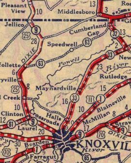
| Adjustments: In 1930, US 25W was removed from Old Clinton Pike in the Bell Bridge area; Old Vasper Rd in Vasper west to the Baptist Church; Old 25 Loop near Habersham In 1931, US 25W was extended south replacing US 25 from Knoxville to the new US 25E (now US 321) routing at Newport.
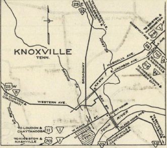
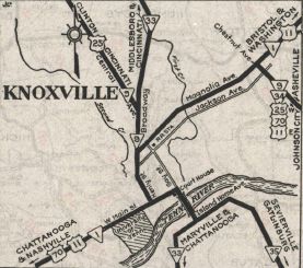
In 1931 or 1932, US 25W was given a more direct path between Dandridge and Newport. The old route used Coops Rd/Carson Springs Rd, Clevenger Cutoff, Old Sevierville Hwy/Bridge Chapel Rd, Old US 411 and US 411 segments to Chestnut Hill; first couple miles of TN 92; underwater routing; Hills Chapel Rd, a little more TN 92; underwater routing; E. Main St in Dandridge Also in 1931 or 1932, US 25W was rerouted in Knoxville westward via Magnolia, Broadway and Central St. The old route used Magnolia, Gay, Summit Hill, Walnut, Summer Pl (no longer connects to), Summit Hill, Western Ave (used Old Western Ave in West Knoxville), and Pleasant Ridge Rd to today's US 25W.
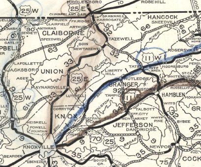
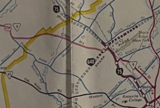
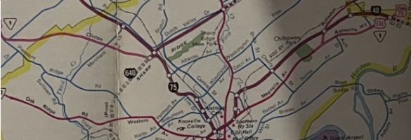
In 1931 or 1932, TN 9 had been given a more direct route from Trentville to Knoxville. The original routing became part of TN 34. Today this is Strawberry Plains Pike, Boyds Bridge Pike, Biddle St and S. Chestnut St. However, it appears that the US routes following TN 9's original path continued to follow this path until at least 1933. In 1933, US 25W was removed from Carter School Rd/Strawberry Plains Pike in Trentville. In 1934, US 25W south was truncated to the current US 25E routing west of Newport, replaced by a slightly longer US 25. In 1935, US 25W was removed from Old Vasper Rd west of the Baptist church. Also in 1935, Tennessee requested US 25W be renumbered as US 25A north of Knoxville instead of US 129 AASHO turned this down. If US 25W ever used Powder House Rd or Mimosa Circle south of Clinton it stopped doing so by 1936. In 1940, US 25W was removed from Carden Farm Dr/Old SR 25 (no longer connects to)/Broad St into Clinton. In 1944, US 25W was removed from Old Clinton Hwy and Old State Circle in the Bull Run area In the 1940s, I am guessing US 25W was removed from Hiway Dr in S. Clinton; Tussey Cut near Morley In 1947, US 25W was removed from Old Jacksboro Hwy south of La Follette About 1956, US 25W was removed from Holston Dr in eastern Knoxville About 1960, US 25W was put onto newly constructed I-75 (now I-275) from Heiskell Ave through Sharp Gap to where Clinton Hwy brnaches northwest at the I-75-275-640 junction. I-75 was put on US 25W's footprint except right at Heiskell Ave US 25W used the frontage Rd and the Penske Truck parking lot. Between 1965-71, US 25W was put on more I-75 (now I-275), leaving behind Broadway, Central and Heiskell. In the late 1960s, US 25W was placed on I-75 between Rocky Top and Jacksboro. The old route used today's TN 116 (some of I-75's NB lanes used US 25W's footprint between Vasper and Jacksboro, though) In 1968, US 25W was removed from Main St through Jacksboro. In 1979, Tennessee presented AASHO a proposal, as part of eliminating US 25W, that would have dropped US 25W from US 70 east of Knoxville; rerouted US 119 and La Follette to Jellico would've gone back to being just TN 9.
 US 25W elimination scheme 1979 TDOT Correspondence to AASHO About 1982, US 25W was put onto I-40 and I-640 around the east and north of Knoxville. Magnolia St became TN 168 between I-40 and US 11W and TN 1 remains on Magnolia.
 US 25W moved onto I-40/640 instead 1989 Official Posting: Fully posted Secret TN Route Overlay: TN 9 (entire route) Comment: Given that US 25W is so close to I-75, it would still make sense to get rid of that and make US 25E become US 25. The Clason's map error may be based upon AASHO's mistaken belief that US 25W did actually run that way, but Tennessee wrote to AASHO and got that corrected. | ||||||||||||
Previous: US 25E |
Next: US 27
Top | Tennessee Hwy Index
Home
Page last modified 10 July 2021