| U.S.
19 144 miles |
|
|
|
|
| The Road: |
|
Enters from Georgia at Bellview (Cherokee County) and ends at US 19E-19W Cane Creek (Yancey County). Nationally the road runs from US 41 Terra Ceia, FL to US 20 Erie, PA
|
Towns and Attractions: |
|
Cherokee Co.: Murphy, Andrews
Macon Co.: Nantahala Nat'l Forest
Swain Co.: Bryson City, Cherokee
Jackson Co.: None
Haywood Co.: Blue Ridge Pkwy, Lake Junaluska, Clyde, Canton
Buncombe Co.: Enka, West Asheville, Asheville, Weaverville
Madison Co.: Pisgah Nat'l Forest
Yancey Co.: None
|
History: |
|
US 19 is an original late 1926 US Highway. It attached itself to NC 10 from Georgia to Asheville - this had been US 270 in the 1925 plan; NC 29 Asheville to Forks of Ivy; NC 69 Forks of Ivy to Cranberry; NC 194 Cranberry to Tennessee.
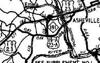
US 270 southwest of Asheville
1926 Auto Trails
|
US 19 southwest of Asheville
1928 Gen Draft
|
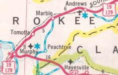
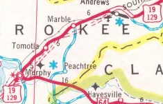
It entered from Georgia at Bellview and headed up SR 1556 Martin's Creek Rd to Murphy. Then US 19 followed today's US 19 Bus through Murphy; present US 19-74-129 through Regal; SR 1370 Old Tomotla Rd through Tomotla.
US 19 picked up SR 1426 Tomotla Rd; more US 19-74-129; SR 1428 Airport Rd/Andrews Hwy. through Marble and Coalville. The route then followed US 19 Bus through Andrews. North of here, US 19 essentially followed its current route (except used SR 1394 loop near Rhodo) to today's NC 28.
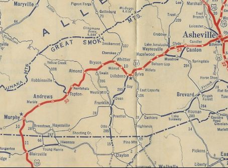
US 19 originally used NC 28 west to Almond. Here the road can no longer be followed as it headed north across the Little Tennessee River, now part of Fontan Lake. US 19 used today's SR 1309 Lower Alarka Rd east to current US 19 at Jackson Line. US 19 then followed current US 19 to Bryson City.
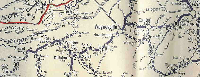
At first US 19 followed its current route to Ela, then slid southeast on SR 1195 to Whittier. Here, US 19 picked up current US 74-441 southeast to near Dillsboro, where it used SR 1514 Haywood Rd, then US 23 Business to Sylva (may have briefly used SR 1381 Dr Wilkes Dr).
US 19 followed SR 1432 Skyland Dr through Beta and Addie to Willets before picking back up today's US 23-74. US 19 used SR 1472 Balsam Loop Rd through Balsam. After more US 23-74, US 19 used SR 1243 Old Balsam Rd through Saunook to Hazelwood.
US 19 picked up US 23 Business through Waynesville to Lake Junaluska. US 19 then followed NC 209 north a little, then SR 1523 Old Clyde Rd east through Clyde and Phillipsville to Canton. SR 1523 used to connect to current US 19-23/NC 215 just west of Watts St.
After a stretch on current NB US 19-23, US 19 originally followed SR 1600 Groundhog Rd to Buncombe County, then SR 1130 "Old NC 19-23" through Luther to Candler Heights. US 19 then picked back up current US 19-23 to Enka.
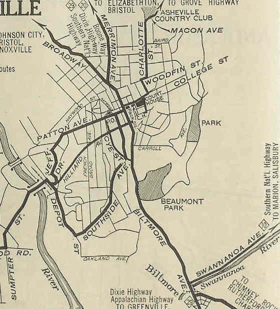
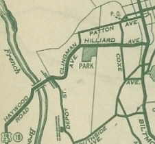
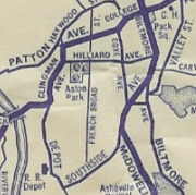
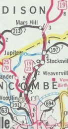
US 19 initially followed current US 19-23-74 to West Asheville, then US 19 Bus-23 Bus. At I-240, US 19 initially continued on Haywood St across the French Broad River to Jefferson Dr to Patton Dr to Broadway to Merrimon north out of Asheville. US 19 followed today;s US 25, then US 19 Bus through Weaverville.
North of Weaverville, US 19 followed SR 2148 Old Mars Hill Hwy through Stockville and Flat Creek, then across the freeway it used SR 2207 Stockton Rd to SR 1610 Forks of Ivy Rd and then SR 1540 Beech Glen Rd. US 19 followed this through Ivy to current US 19. US 19 used several SR loops through the Buckner area and the longer SR 1507 "Old US 19" to Ivy Gap.
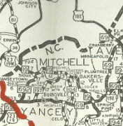
US 19 more or less followed its current routing (several SR loops) to US 19E-19W. Then US 19 followed US 19W to Old US 19E and Cane River Middle School Rd to about Riverside. US 19 likely used SRs 1195 and 1196 to zig zag over to Main St Burnsville.
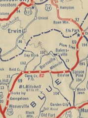
US 19 used Main St through town, then some US 19E. It used Old US 19E to Windom. Past there US 19 used US 19E until Micaville, where it used SR 1186 and a little NC 80. East of there, 19 picked up US 19E again, plus several short loops of old highway to Mitchell County.
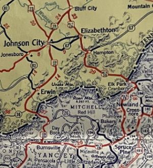
US 19 followed US 19E in Mitchell county except for a brief Old US 19E east of Eastatoe over to Spruce Pine. US 19 used Greenwood Rd then NC 226 to cross North Toe River, then Oak St and Cabin road to continue east. US 19 then used essentially US 19E all the way to Tennessee.
In 1930, US 19 north was truncated to the current US 19W jct with Old US 19E in Cane River. US 19 northeast through Spruce Pine to Tennessee became US 19E.
 US 19 through Spruce Pine to Tennessee
1928 Gen Draft
|
 US 19E replaces some of US 19
1930 Official
|
In May 1930 (AASHO), Georgia wanted to extend US 23 further, from Asheville to Atlanta. Because Georgia was going to reroute US 19 to avoid a long US 23 overlay there, AASHO wanted to swap US 19 and US 23 south of Sylva so that 23 would be west of 19. After months of vigorous protests from towns along US 19 and NC itself. AASHO relented in July 1930 on allowing US 23 to remain east of US 19.
By 1932, it appears US 19 was rerouted in Asheville to use Haywood to Clingman to Hilliard to Biltmore which turns into Broadway.
In 1935, AASHO tried to get Tennessee to renumber US 19W as US 19. Tennessee declined to do this, but this change showed up on some commercial maps 1935-37. However the 1935, 1936 and 1938 Official maps all show US 19W in place and there is no mention of this in AASHO correspondence with North Carolina.
US 19W back to US 19?
1935 Gen Draft
By 1937, it appears US 19 was rerouted to use Clingman to Patton to College to Biltmore.
About 1937, US 19 was rerouted away from Almond to its current routing over to Jackson Line. Some of this was new construction but a little of NC 286 was replaced in the process.
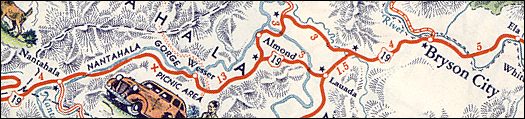
Here is a map that shows old and new alignments of US 19 in the Almond area
1941 Gen Draft
Between 1939-44, US 19 was removed from Cherokee SR 1394.
Between 1939-44, US 19 was rerouted in Waynesville to use US 276 Russ St to Walnut St back to US 23 Bus. The old Main St routing became US 19A-23A.
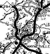
US 19-23 on Main St. in Waynesville
1936 Haywood County
|
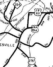
US 19-23 rerouted in Waynesville
1944 Haywood County
|
Between 1945-49, US 19 was removed from "Old NC 19-23" through Luther.
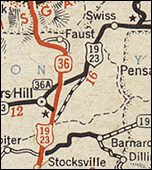
About 1947, US 19 was rerouted in the Mars Hill area. It was removed from Beech Glen Rd and instead followed essentially US 19's current routing. North to the current I-26/US 19 split was already part of NC 36. East from there to SR 1540 had been part of NC 213.
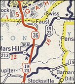 US 19 Madison County (1927-46)
1946 Gen Draft
|
 US 19 assumes modern routing corridor
1947 Gen Draft
|
In 1948, US 19 was rerouted east of Ela to instead run east through Cherokee and Soco Gap to reach Lake Junaluska, using the current US 19 routing to today's NC 209 where it rejoined the historic US 19 routing. This was a swap with US 19-A.
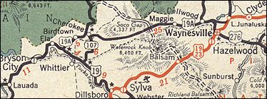
US 19 through Sylva and Waynesville
1947 Gen Draft
|
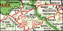
US 19 through Cherokee and Soco Gap
1952 Official
|
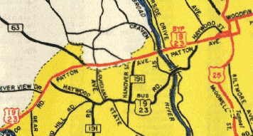
Around 1949, US 19 was placed on a bypass of West Asheville to its current route on Patton Ave. The old route became US 19A-23A (some is still US 19 Bus-23 Bus).
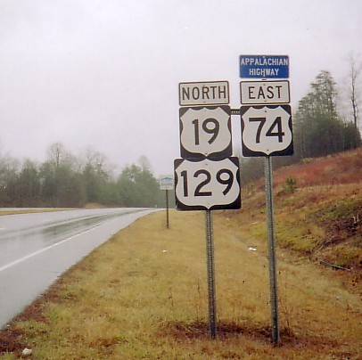
About 1952, US 19 was routed off Martins Creek Rd onto current US 19-129 from Georgia to Murphy.
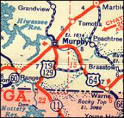
US 19 original Murphy approach
1948 Rand McN
|
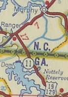
US 19-129 rerouted to Murphy
1952 Shell
|
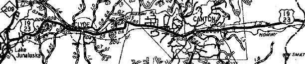
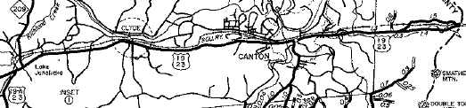
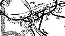
About 1954, US 19 was placed on its current routing from Lake Junaluska through Clyde and Canton. Also it was removed from SR 1600 near Buncombe County. The old route became all secondary except NC 209 absorbed about a half-mile of it.
US 19-23 on Old Clyde Rd
1949 Haywood County
US 19-23 moved to current routing
1957 Haywood County
In 1954, US 19 was given its current alignment through eastern Madison County through Buckner up to Ivy Gap. This left behind SR 1537 Old Mil Bridge Rd; SR 1519 Old Buckner Post Office Rd; SR 1513 Ruth Cir; SR 1511 Bethel Cir; SR 1507 Old Mountain Rd.
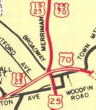
Between 1955-57, US 19 was given a split routing in downtown Asheville: NB used Patton to Market north to Woodfin west to Broadway north. SB used Broadway south to College west to Patton.
About 1961, US 19 was removed from downtown Asheville and placed on the East-West Expressway. US 19 continued to used Merrimon north from the expressway. The '61 Official suggess US 19 Business was extended into downtown.
 US 19 bypasses W. Asheville
1949 Buncombe County
|
 US 19 on one-way splits
1960 Official
|
 US 19 moved in 1961
1961 Official
|
About 1962 (bridge date), US 19 was placed on one-way splits through Canton, with SB using Park St and NB using a new Pigeon River Bridge onto Main St.
US 19 original Canton routing
1962 Haywood County
|
US 19 on one-way splits in Canton
1968 Haywood County
|
In September 1967 (NCDOT), US 19 was placed on new freeway to bypass Weaverville, leaving behind US 19 Business.
In February 1972 (NCDOT), US 19 was removed from Merrimon St (remained US 25) and placed on its current freeway leaving Asheville.
In October 1975 (NCDOT), US 19 was placed on more freeway from Weaverville to Mars Hill leaving behind SR 2207 Old Mars Hill Hwy, SR 1610 Forks of Ivy Rd, and also snippets of SR 1605 Calvin Edney Rd and SR 1606 Crossroads Pkwy (the freeway was built on top of swaths of the US 19-23 alignment.
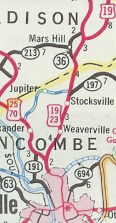 US 19 on Merrimon and through Weaverville
1963 Official
|
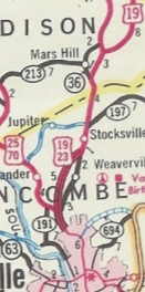 US 19 bypasses Weaverville
1968 Official
|
 US 19 removed from US 25 Merrimon
1974-75 Official
|
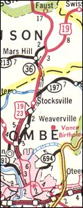
 US 19 freeway to Mars Hill area
1979-80 Official
|
In January 1979 (NCDOT), US 19-129 was placed on a new bypass of Andrews leaving behind US 19 Business.
Also in January 1979 (NCDOT), but not shown on maps until a year after Andrews bypass was, US 19-129 was placed on a new bypass of Murphy (leaving behind US 19 Bus) and a lot of new alignment connecting to the Andrews Bypass.
 US 19-129 through Murphy and Andrews
1978-79 Official
|
 US 19-129 bypasses Andrews
1979-80 Official
|
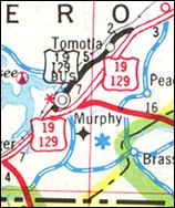 US 19-129 bypasses Murphy
129 Bus is in error
1980 Official
|
In May 1982 (AASHTO), NCDOT requested that US 19 and 19-A swap routings between Ela and Lake Junaluska.
In June 1982 (AASHTO), NCDOT withdrew the US 19/19A swap request due to community opposition.
In December 1984 (NCDOT), US 19 north was truncated to the current US 19E-19W split, leaving behind an extended US 19W.
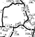 US 19 north end (1930-1984)
1968 Yancey County
|
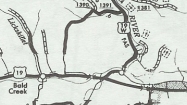 US 19 north end (since 1984)
1987 Yancey County
|
In 1985 or 1986, US 19 was removed from several roads in Yancey County: SR 1449 Jessie Rd; SR 1202 Swiss Loop; SR 1451 Creekside Rd/Sconce Creek Rd; SR 1452 Lewis Rd; SR 1453 Walking Rd
Between 1992-94, US 19/74-NC 28 was removed from SR 1394
About 2011, US 19 was removed from SR 1641 Wagon Rd east of I-26/US 23.
|
Comments: |
|
US 19 has been usurped as southwest N.C.'s premier route by US 74. Long term plans call for a new corridor to bypass the Nantahala Gorge. The route would utilize the multilane portion of NC 28 through Almond then cut down as new construction to existing US 19-74. Since US 19 is on the old routing in the Bryson City region while US 74 enjoys freeway status, I wonder if US 19 will continue to use the old routing through the Gorge.
North of Mars Hill, US 19 is more of a regional corridor than a true through route with the emergence of I-26 providing easy access to the Tri-cities area of Tennessee.
|