< Mystery Corridors | Home | US 5 >
US 1 Business | US 1 ALT
US 301 | US 401 | US 501
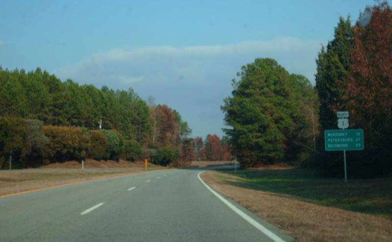
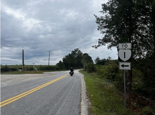
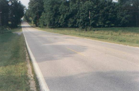
Photo: US 1 in the Alberta area (photo by Mapmikey 11/10/07)
|
|
|
| ROUTE LOG |
NC STATE LINE: 0 - 0 US 58 WB: 8.97 - 8.97 US 58 EB, US 58 Bus BEGIN: 3.43 - 12.40 US 58 Bus EB, VA 47: 2.81 - 15.21 VA 138: 2.92 - 18.13 I-85 (exit 15): 0.25 - 18.38 Brunswick-Mecklenburg Line: 3.29 - 21.67 VA 46: 8.12 - 29.79 I-85 (exit 28): 1.25 - 31.04 VA 136: 0.80 - 31.84 Dinwiddie-Brunswick Line: 10.67 - 42.51 VA 40: 2.69 - 45.20 US 460 Bus WB: 18.21 - 63.41 VA 142: 1.49 - 63.90 I-85 (exit 63): 0.20 - 64.10 VA 319: 0.60 - 64.70 VA 226: 0.63 - 65.33 VA 357: 0.25 - 65.58 VA 319: 0.03 - 65.61 Petersburg-Dinwiddie Line: 0.17 - 65.78 VA 36 WB: 2.38 - 68.16 US 301 ALT SB: 0.20 - 68.36 US 460 Bus EB, VA 36 EB: 0.20 - 68.56 US 301 SB, US 301 ALT END: 0.45 - 69.01 Colonial Heights-Petersburg Line: 0.43 - 69.44 VA 144 SB: 1.52 - 70.96 Chesterfield-Colonial Heights Line: 1.72 - 72.68 VA 144 NB: 0.22 - 72.90 VA 10: 4.80 - 77.70 VA 288: 1.65 - 79.35 VA 145: 2.26 - 81.61 VA 150: 2.41 - 84.01 Richmond-Chesterfield Line: 1.17 - 85.18 VA 161: 0.75 - 85.93 US 360: 3.15 - 89.08 US 60: 0.39 - 89.47 VA 195: 1.33 - 90.80 VA 147: 0.10 - 90.90 US 250: 0.40 - 91.30 VA 33: 0.20 - 91.50 I-64, I-95 (exit 76): 0.10 - 91.60 VA 197: 2.29 - 93.89 US 301 NB, VA 2: 1.20 - 95.09 Henrico-Richmond Line: 0.26 - 95.35 I-95 (exit 81): 0.30 - 95.65 VA 161: 0.83 - 96.48 VA 73: 1.20 - 97.68 I-295 (exit 43): 1.42 - 98.10 Hanover-Henrico Line: 1.71 - 99.81 VA 54: 5.46 - 105.27 VA 30: 6.23 - 111.50 Caroline-Hanover Line: 3.04 - 114.54 VA 207: 2.99 - 117.53 Spotsylvania-Caroline Line: 11.88 - 129.41 US 17 SB: 9.13 - 138.54 I-95 (exit 126), US 17 NB: 1.18 - 139.72 US 1 Bus, VA 208: 0.96 - 140.68 Fredericksburg-Spotsylvania Line: 1.30 - 141.98 VA 3: 1.48 - 143.46 US 1 Bus, US 17 Bus SB: 1.78 - 145.24 Stafford-Fredericksburg Line: 0.11 - 145.35 US 17 Bus NB, VA 218: 0.35 - 145.70 I-95 (exit 143): 8.83 - 154.53 Prince William-Stafford Line: 4.73 - 159.26 VA 234: 4.63 - 163.89 VA 123: 7.10 - 170.99 Fairfax-Prince William Line: 0.40 - 171.39 I-95 (exit 161): 0.81 - 172.20 VA 242: 1.44 - 173.62 VA 235: 5.37 - 178.99 VA 235: 2.84 - 181.83 VA 241: 3.19 - 185.02 Alexandria-Fairfax Line: 1.31 - 186.33 I-95 (exit 177), I-495: 0 - 186.33 VA 7: 1.02 - 187.35 VA 236: 0.20 - 187.55 Arlington-Alexandria Line: 2.21 - 189.76 VA 120: 0.15 - 189.91 VA 233: 0.65 - 190.56 I-395 SB (exit 9), VA 110: 1.03 - 191.59 GW Pkwy: 0.55 - 192.14 DC Line: 0.02 - 192.16
|
Creation: Appeared in late 1926 as an original US Highway, running essentially as it does now, as an addition to VA 31.
| Here is a detailed look at US 1's original routing:
SR 903 out of South Hill down to SR 615, then west until it nears US 1 where VA 31 cut SW to cross the Roanoke River on a private toll bridge. VA 31 then followed SR 711 to Palmer Springs, then either SR 712 over to VA 4 where it then dipped into North Carolina or SR 713 southeast to the current US 1 crossing
US 1 entered Virginia where it does now, then used SR 713 to Palmer Springs, then SR 711 NE to cross the Roanoke River on a private toll bridge very near the current US 1 bridge, connecting up with SR 903 which US 1 followed to South Hill.
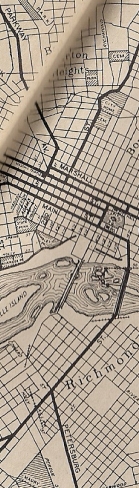
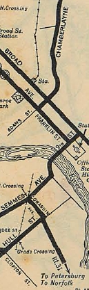
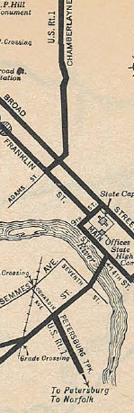
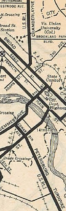
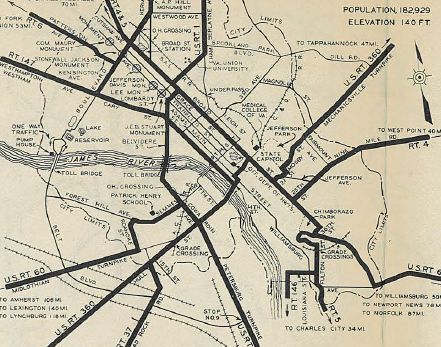
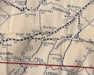 US 1 to N.C. via Forksville and SR 903 1926 Auto Trails US 1 followed current US 1-301 to Richmond except it used SR 1625 in the VA 145 area and it used the Hull St bridge to cross the James River. US 1 then headed west on Main, north on 9th, west on Broad, north on Adams, then north on Chamberlayne. US 1 used Norwood west to Brook Rd north out of Richmond. US 1 used its current routing from Ashland to Four Mile Fork except for SR 641 loop north of Ashland. US 1 then used current US 1 BUsiness through Fredericksburg, including Princess Anne St. US 1 crossed the Rappahannock just west of the current US 1 bridge and used SR 607 up the hill to the current US 1/US 17 Bus split in Falmouth. US 1 used SR 627 Forbes St which no longer connects back to US 1 near the SR 8900 jct. US 1 followed US 1 briefly, then used State Shop Rd, a bit of SR 628, and abandoned routing back across US 1 and a closed Accokeek Creek Bridge, then back across US 1 to pick up SR 742 back to US 1 into Stafford CH. US 1 used SR 631 Bells Hill Rd then abandoned routing to connect with SR 697 Derrick Ln. US 1 did use SR 660 to Quantico MCB, then used abandoned routing to connect onto Purvis Rd through Base Housing. At the point where Purvis Rd takes a hard turn to the east, VA 31 continued north on abandoned alignment to meet US 1 near SR 619. US 1 used the SB split through Dumfries and current US 1 to Alexandria except it used parts of Meade Rd and Casey Rd at Ft Belvoir; Buckman Rd; Sherwood Hall/Fordson Rd. US 1 used Franklin St east to Washington St north through Alexandria, then Powhatan St back to current US 1. US 1 then used Old Jefferson Davis Hwy in the Crystal City area, then crossed the Potomac very close to the current I-395 bridge. Adjustments: In 1927, US 1 was placed on current US 1's routing from North Carolina to Petersburg except for Pace Drive in South Hill. Also around 1927, US 1 was removed from the Hull Street bridge in Richmond and instead used Cowardin St to Semmes Ave to use the 9th St bridge to Franklin St to Adams/Chamberlayne. In 1930, US 1 was removed from the 9th St Bridge in Richmond and went back to using Hull St bridge, then Main St west to 9th St then Franklin, etc. Also in 1930, US 1 was placed on today's US 1 in Falmouth and southern Stafford County. In 1931, US 1 was rerouted in Petersburg to use Bank St from Sycamore to the Appomattox Bridge landing instead of Bollingbrooke. In 1932, US 1 was removed from the Hull St bridge in Richmond and returned to the 9th St bridge. Then US 1 used 9th St to Broad St west to Adams/Chamberlayne. Also by 1932, US 1 was removed from the Fordson/Sherwood Hall Loop.
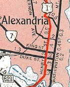
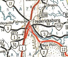
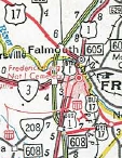
In July 1933, VA 31 was dropped from the entirety of US 1. In April 1934 (CTB), US 1 was rerouted in Richmond to use Belvidere across the James River, then Broad St west to Lombardy north to Chamberlayne. In Dec 1934 (CTB), US 1 was placed on its modern routing in Central and Northern Stafford County including Quantico MCB. About 1935, US 1 was reomved from SR 1425 and what became an extended VA 145. Also in this timeframe US 1 was given its modern routing through the Fort Belvoir area. By 1936, US 1 was removed from Fordson Ln and Old Richmond Hwy approaching Alexandria. In Sept 1937 (CTB), US 1 was removed from Hanover SR 641. In 1943, US 1 was given its current Rappahannock crossing leaving behind a bit of SR 607 in Falmouth. In June 1947 (CTB), US 1 was rerouted in Alexandria to replace what had been US 1 ALT - Patrick St, Wilkes, Henry, and Old Georgetown Rd (now part of Henry). The old route using Franklin, Washington, and Powhatan was taken out of the primary system.
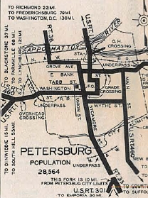
In Aug 1951 (CTB), US 1 was rerouted through Petersburg: NB followed Washington to N. Adams (had been US 1 ALT) to Henry St to 3rd St to Bollingbrook west to the Appomattox Bridge location; SB used Bollingbrooke west to N. Sycamore St north to Grove Ave west to Market south to Washington. In Nov 1953 (CTB), US 1 was placed on one-way splits in Richmond: NB used Broad St, Bowe St, Moore St, Lombardy St; SB used Lombardy St and Broad St. I have yet to find a Richmond map that shows the US 1 and US 60 routings used throughout most of the 1950s. In Oct 1954 (CTB), US 1 was placed on its current routing through Crystal City. At some point after 1958, US 1 was operationally placed on one-way splits in Downtown Fredericksburg with NB using Caroline St/Herndon St and SB using Princess Anne St. In Sept 1959 (CTB), US 1 was given its current routing through Richmond with the completion of Chamberlayne connecting to Belvidere directly.
It appears that around 1960, US 1 was given its one-way splits with Patrick and Henry Sts. in Alexandria. In May 1971 (AASHO), US 1 was moved to the Fredericksburg bypass, replacing US 1 ALT. The old route through downtown Fredericksburg became US 1 Business.
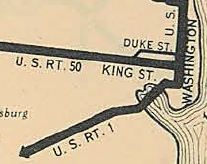
About 1976, US 1-460 was placed on one-way splits using Washington and Wythe Sts
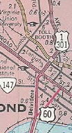
Improvements: Upon designation in 1926, US 1 was fully paved from Dinwiddie to Washington DC except for a brief section south of Stafford CH In 1927, US 1 was paved from North Carolina to Dinwiddie. In 1932, US 1's Stafford section was paved. Note that widening of US 1 for 3-laning began as early as 1931. The First segment of US 1 to be 4-laned was the split north of Stafford CH, in 1933 (NB bridge date). By 1937, US 1 was multilaned from VA 10 to Richmond. In 1938, US 1 was multilaned at least Ashland northward to the S. Anna River By 1941, US 1 was multilaned from Petersburg to Washington except near Four Mile Fork to Stafford SR 628; Woodbridge area By 1947, US 1 was multilaned in the Woodbridge area. In 1951, US 1 was multilaned 3 miles around the Meherrin River; a segment by Brunswick SR 712; DeWitt north a short distance. In 1952, US 1 was multilaned from VA 46 past Alberta; DeWitt to Dinwiddie In 1971, US 1 was multilaned when placed on the Fredericksburg bypass. In 1992, US 1 was multilaned on its US 58 duplex. In 2005, US 1 was widened to 6-lanes in the SR 8900 Centreport Pkwy area In 2013, US 1 was widened to 6-lanes through Triangle In 2016, US 1 was widened to 6-lanes from SR 610 south of Dale City to just past SR 2000 Opitz Blvd Woodbridge In 2020, US 1 was widened to 6-lanes from Mary's Ln to just north of VA 123 in Woodbridge In 2023, US 1 was widened to 6-lanes from just past SR 2000 Opitz Blvd to Mary's Ln in Woodbridge The parts of US 1 that are not 4-laned from North Carolina to Petersburg are 3-laned (some now have the center turn lane setup) with the exception of a small section from the state line northward. US 1 is 6+ lanes from VA 150 to Overbrook Rd in Richmond (about 12 miles); Azalea Rd Richmond; VA 73 to Hanover SR 656; about a mile from I-95 Exit 126 southward; 1/2 mile in the vicintiy of SR 8900; through Triangle; SR 610 south of Dale City to just past VA 123; 3/4 mile in Lorton; VA 235's northern jct to the RR bridge north of Old Town Alexandria; Reed Ave to Washington DC
Legislative names: Jefferson Davis Highway, US 58 duplex; SR 712 to Washington DC (3-17-22 designation predates US 1); Blue Star Memorial Highway , Occoquan River to VA 235 (4-3-90); Purple Heart Trail, I-95 Exit 161 to VA 235 (4-8-98); Washington-Rocheambeau Highway, Fredericksburg to SR 611 Occoquan River; SR 611 Pohick to VA 235 (3-6-80) Spanish-Amercian War Veterans Memorial Bridge over Rohoic Creek in Petersburg (3-12-38); Dr. Martin Luther King Jr Memorial Bridge over Appomattox River (4-16-92) Other names: Danville St/Mecklenburg Ave (South Hill); Boydton PLank Rd (Brunswick and Dinwiddie Co); [Wythe St/Jefferson/3rd St/Bollingbrook St/2nd St NB]/[Bollingbrook St/Sycamore St/Old St/Market St/Washington St SB] (Petersburg); Boulevard (Colonial Heights); Cowardin Ave/Lee Bridge/Belvidere St/Chamberlayne Ave/Azalea Ave (Richmond); Brook Rd (Henrico Co); Washington Hwy (Hanover Co); Fraley Blvd NB/Main St SB (Dumfries), Richmond Hwy (Fairfax Co); Patrick St NB/Henry St SB (Alexandria) Scenic Byway: No segments Truck Route: US 1 SB has a truck route posted in Petersburg, following US 301 ALT south to US 460 Bus east. Comments: Historically the most important road on the East Coast, it has been pretty much superceded in Virginia by I-95 and I-85. It still provides a great low-traffic, four-lane alternative between Fredericksburg and Richmond. Above Fredericksburg, though, it's one stoplight after another. The last 55 mph section is a 2-mile segment between SR 624 near Falmouth and SR 628 south of Stafford CH. Until 1998, US 1 in Dumfries had an interesting alignment. The road split far apart. US 1 NB was straight and 2 lanes in the same direction. US 1 SB was quite crooked, and for half of it was two-way traffic, with only 1 lane in each direction. This created a bottleneck everyday during afternoon rush. VDOT added a second SB lane in 1999. US 1 had the last known suicide lane setup in Virginia, a little south of US 58, where both directions could come to the middle to pass. This was finally changed before early 2004. Here is a picture - thanks to Gribblenation | ||||||||||||||||||||
Previous: Mystery Corridors |
Next: US 5
US 1 Business | US 1 ALT
US 301 | US 401 | US 501
Top | Virginia Hwy Index
Home
Page last modified 4 January 2024