< VA 30 | Home | VA 32 >
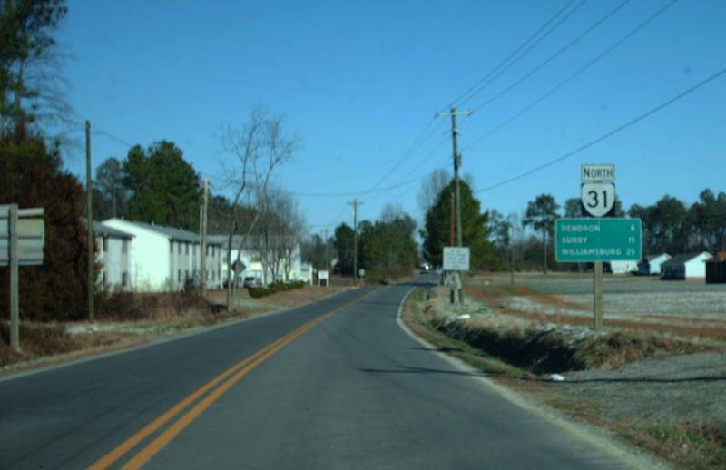
Photo: VA 31 Northbound leaving Wakefield (photo by Mapmikey 1/21/08)
|
|
|
| ROUTE LOG |
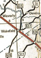
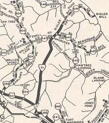
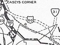
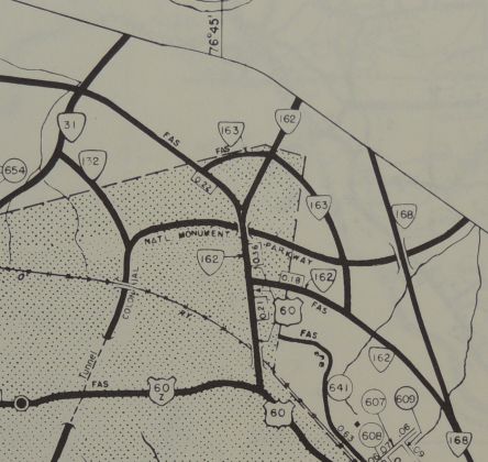
US 460: 0 - 0 Surry-Sussex Line: 3.66 - 3.66 VA 10 WB: 10.99 - 14.65 VA 10 EB: 1.04 - 15.69 Scotland Ferry: 4.41 - 20.10 James City-Surry Line: 0 - 20.10 Jamestown Ferry: 0 - 20.10 VA 359: 0.40 - 20.50 Williamsburg-James City Line: 4.00 - 24.50 VA 5, VA 199: 0.06 - 24.56
|
Creation: Appeared in July 1933 as a renumbering of VA 542 from Ft. Magruder to Williamsburg; VA 510 from Williamsburg to Wakefield; VA 547 from Wakefield south to SR 600. This is the 2nd VA 31.
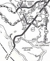
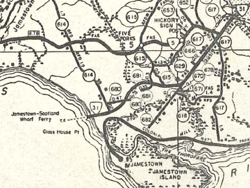
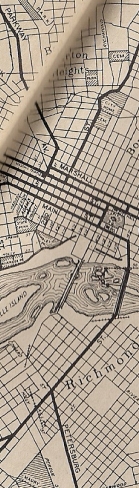
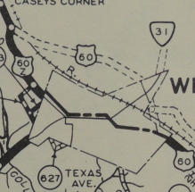
| Adjustments: In Sep 1937 (CTB), VA 31 was extended south over SR 628 to just short of the Southampton County Line. It appears that in July 1940 (CTB) VA 31 was rerouted off Duke of Gloucester St to instead use France St and Francis St in central Williamsburg. Between 1942-44, VA 31 was rerouted south of Williamsburg to a new (current) ferry landing on largely new routing. Up to this point, VA 31 had used today's SR 682 Neck-O-Land Rd, then curled west along today's Colonial Pkwy, then cut south at the parking area to a causeway (still visible on Google Earth) and crossed Thoroughfare Creek onto Jamestown Island to meet the ferry in the area of the historic settlement. The bridge onto Jamestown Island was identified for replacement in the Sept 1941 CTB and money was transferred from that project to VA 35 in March 1942 CTB. I could find no other mention of what happened here.
In April 1944 (CTB), VA 31 south was truncated to US 460 Wakefield leaving behind SR 628.
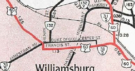
In May 1957 (CTB), VA 31 was restored to its pre-1955 routing through Williamsburg via US 60-Z and US 60, and displacing VA 162 on Capitol Landing Rd. The Henry St routing became current VA 132. In Aug 1958 (CTB), VA 5 was added to VA 31 through Williamsburg. In June 1973 (CTB), VA 31 was rerouted in central Williamsburg to follow Duke of Gloucester St, Henry St, LaFayette St and York St to US 60. Francis St became unnumbered. In July 1974 (CTB), VA 31 was removed from Duke of Gloucester St (permanently closed to vehicles) and instead used Boundary south to Francis east to Henry (as it runs today).
In Oct 1980 (CTB), VA 31 was removed from SR 663 Tower Dr south of Surry CH. In July 1991 (CTB), VA 31 was removed from SR 700 Rolfe Ct below Dendron. In 1994, VA 31 north was truncated to its current end, leaving behind VA 5. Improvements: Paved upon its inception except south of Wakefield. VA 31 was fully paved in 1934. In 1981, VA 31 was multilaned on its US 60 duplex. Posted: Fully posted; numerous cutouts existed in Williamsburg up to the mid-90s as did one cutout on SR 626 EB at Surry CH (all are gone now). Multiplexes: VA 10 (1.04 mi) Legislative names: The Rolfe Hwy, entire route (since 3-29-34) Other names: Jamestown Rd (north of ferry) Scenic Byway: No segments Comment: The ferry is the last one in Virginia that a primary route utilizes. It is a nice respite on a summer day's drive. VA 31 is misidentified as VA 13 on the 1974 official map Williamsburg inset. The 1939 VDOT report on primary system development had recommended that VA 31 be decommissioned from Wakefield to Surry. | Previous VA 31's:
1932 ROUTE LOG NC STATE LINE: 0 - 0 US 58 WB, VA 12 WB: 9 - 9 US 58 EB, VA 12 EB, VA 434: 6 - 15 VA 401: 15 - 30 VA 437: 2 - 32 VA 402: 10 - 42 VA 48: 3 - 45 VA 426: 10 - 55 VA 439: 12 - 67 VA 10 WB: 1 - 68 US 17-1, VA 10 EB, VA 35, VA 409: 3 - 71 VA 407: 9 - 80 VA 410: 4 - 84 US 60 WB, VA 13 WB, VA 20: 10 - 94 US 60 EB, VA 13 EB, VA 39 EB: 1 - 95 VA 19: 1 - 96 VA 41: 0.5 - 96.5 VA 421: 2.5 - 99 VA 39 WB, VA 50: 16 - 115 VA 51: 4 - 119 VA 613: 8 - 127 VA 614: 6 - 133 VA 615: 5 - 138 VA 51: 13 - 151 US 17, VA 38 EB: 4 - 155 VA 37: 0.5 - 155.5 VA 38 WB: 1.5 - 157 VA 618: 9 - 166 VA 619: 3 - 169 VA 709: 10 - 179 VA 25: 8 - 187 VA 725: 11 - 198 VA 710: 3 - 201 VA 717: 3 - 204 US 50 WB, VA 36: 2 - 206 VA 54: 2 blocks - 206 VA 25: 3 - 209 DC LINE: 2 - 211 1940 ROUTE LOG |
VA 31 #1: Appeared in 1923 as a renumbering of VA 1, running from VA 12 (now SR 606) Edgerton to Washington DC:
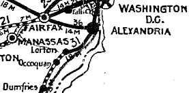
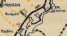
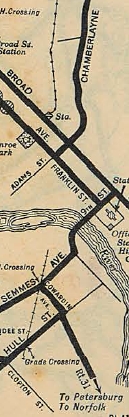
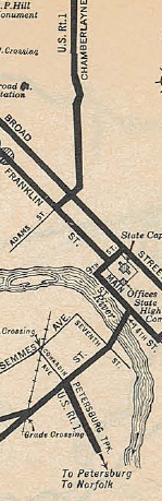
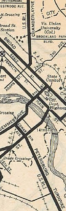
VA 31 initially used today's SR 712 north through Smoky Ordinary to US 1 near the Nottoway River. VA 31 did not use SR 1009 into McKinney and was using US 1's corridor over to DeWitt except the SR 649/650 loop. It appears VA 31 followed US 1's corridor into western Petersburg. VA 31 used Washington St to Sycamore north ot Riverside east to current US 1's crossing of the Appomattox River. VA 31 followed current US 1-301 to Richmond except it used SR 1625 in the VA 145 area and it used the Hull St bridge to cross the James River. VA 31 then headed west on Main, north on 9th, west on Broad, north on Adams, then north on Chamberlayne. VA 31 used Norwood west to Brook Rd north out of Richmond. VA 31 followed what is generally US 1's corridor up to north of Ladysmith except: several discontinuous Telegraph Rd segments around the Chickahominy River area; SR 661 Old Telegraph Rd; SR 641 Ellets Crossing Rd; SR 788 Atkinson Rd; SR 694 Breedens Rd; SR 720 N. Telegraph Rd; SR 613 loop; SR 657 Telegraph Rd. VA 1 then legislatively veered northwest to Spotsylvania CH. The veering northwest was a concept and not an actual road. VA 31 followed VA 208 and VA 208 Business through Spotsylvania CH and to Four Mile Fork except it used a destroyed loop just before the Ni River; SR 628/629 Smith Station Rd/Foster Rd loop; Ewell Rd east of I-95. VA 31 followed US 1 BUsiness into Fredericksburg and used Princess Anne St northwest out of downtown. VA 31 crossed the Rappahannock just west of the current US 1 bridge and used SR 607 up the hill to the current US 1/US 17 Bus split in Falmouth. VA 31 used SR 627 Forbes St which no longer connects back to US 1 near the SR 8900 jct. VA 31 followed US 1 briefly, then used State Shop Rd, a bit of SR 628, and abandoned routing back across US 1 and a closed Accokeek Creek Bridge, then back across US 1 to pick up SR 742 back to US 1 into Stafford CH. VA 31 used SR 631 Bells Hill Rd then abandoned routing to connect with SR 697 Derrick Ln. Past SR 610, VA 31 may have used today's SR 637 Telegraph Rd to Boswells Corner (but definitely did not after 1925). VA 31 did use SR 660 to Quantico MCB, then used abandoned routing to connect onto Purvis Rd through Base Housing. At the point where Purvis Rd takes a hard turn to the east, VA 31 continued north on abandoned alignment to meet US 1 near SR 619. VA 31 used SR 619 east, then Old Triangle Rd north from Traingle to Dumfries, then Graham Park Rd west to US 1 NB alignment, then Dr. David Kline Dr which no longer connects to US 1 SB alignment at Duke St in central Dumfries. VA 31 then used the US 1 SB alignment north, then the Old Stage Coach Rd loop to VA 234 jct. VA 31 then followed mostly abandoned loop routings along US 1's corridor north to Woodbridge. VA 31 used Easy St and SR 906 Occoquan Rd into Occoquan. VA 31 used the US Bike 1 route accross the Occoquan River, then SR 722 up to VA 123. At the old Lorton Prison, VA 31 used SR 642 Lorton Rd back over to US 1. It appears VA 31 followed US 1 to Alexandria except it used parts of Meade Rd and Casey Rd at Ft Belvoir; Buckman Rd; Sherwood Hall/Fordson Rd.; Old Richmond Hwy north of VA 241 (some now destroyed) VA 31 used Franklin St east to Washington St north through Alexandria, then powhatan St back to US 1. VA 31 then used Old Jefferson Davis Hwy in the Crystal City area, then crossed the Potomac very close to the current I-395 bridge. In 1924, VA 31 was placed on the US 1 corridor from Ladysmith directly to Four Mile Fork over US 1's general corridor except near Massaponax the road used several abandoned alignments/Telegraph Rd pieces plus SR 632 at Thornburg.
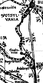
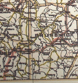
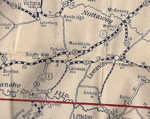
In May 1925 (CTB), VA 31 was rerouted to run from the Nottoway River southwest to South Hill along using SR 629 Rawlings Rd; SR 630 Waqua Creek Rd; US 1; SR 642/606 to Alberta; US 1; SR 710; SR 639 (no longer crosses Meherrin River) to Forksville; SR 638/VA 138; US 1 and Pace Drive to South Hill (a bit of this had been taken into the system near South Hill as VA 314), then extended south replacing VA 122 to the North Carolina line at Palmer Springs and connecting to NC 50. The old route from the Nottoway River to Edgerton became the 2nd VA 122.
Around 1925, VA 31 was removed from Occoquan and instead sent directly to Lorton along US 1's corridor. This left behind VA 315.
In late 1926, US 1 was added to the entirety of VA 31. In 1926, VA 31 was placed on US 1's current routing from Ashland to Four Mile Fork except for SR 641 loop north of Ashland. Also in 1926, VA 31 was placed on current US 1 through Prince William County. In early 1927, VA 31 was placed on today's US 1 from South Hill to North Carolina. The original route used SR 903 out of South Hill down to SR 615, then west until it nears US 1 where VA 31 cut SW to cross the Roanoke River on a private toll bridge. VA 31 then followed SR 711 to Palmer Springs, then either SR 712 over to VA 4 where it then dipped into North Carolina or SR 713 southeast to the current US 1 crossing (it is unclear whether the change to SR 713 came before or after VA 122 was renumbered as part of VA 31 in 1925). In 1927, VA 31 was placed on current US 1's routing from South Hill to Petersburg except for Pace Drive in South Hill. Also around 1927, VA 31 was removed from the Hull Street bridge in Richmond and instead used Cowardin St to Semmes Ave to use the 9th St bridge to Franklin St to Adams/Chamberlayne. In 1930, VA 31 was removed from the 9th St Bridge in Richmond and went back to using Hull St bridge, then Main St west to 9th St then Franklin, etc. Also in 1930, VA 31 was placed on today's US 1 in Falmouth and southern Stafford County. In 1931, VA 31 was rerouted in Petersburg to use Bank St from Sycamore to the Appomattox Bridge landing instead of Bollingbrooke. In 1932, VA 31 was removed from the Hull St bridge in Richmond and returned to the 9th St bridge. Then VA 31 used 9th St to Broad St west to Adams/Chamberlayne. Also by 1932, VA 31 was removed from the Fordson/Sherwood Hall Loop.
In July 1933, VA 31 was dropped from the entirety of US 1.
Previous: VA 30 |
Next: VA 32
Page last modified 28 February 2015 | |||||||||||||||||||||||||||||||||||