< VA 5 | Home | VA 7 >
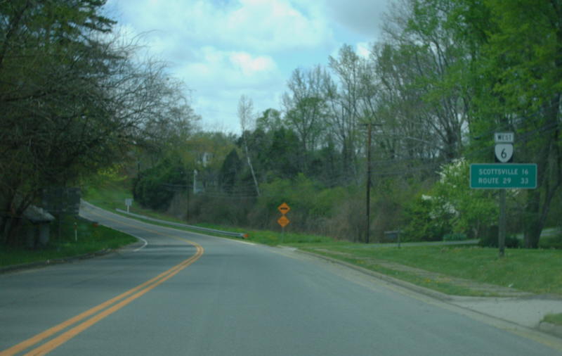
Photo: VA 6 leaving Fork Union (photo by Mapmikey 4/23/08)
|
|
|
| ROUTE LOG |
US 250: 0 - 0 VA 151 NB: 3.72 - 3.72 VA 151 SB: 6.22 - 9.94 VA 6Y: 5.59 - 15.53 US 29 SB: 0.20 - 15.73 VA 6Y: 0.30 - 16.03 US 29 NB: 3.94 - 19.97 Albemarle-Nelson Line: 3.43 - 23.40 VA 20 NB: 12.87 - 36.27 VA 20 SB: 0.58 - 36.85 Fluvanna-Albemarle Line: 0.28 - 37.13 US 15 SB: 15.86 - 52.99 US 15 NB: 1.99 - 54.98 Goochland-Fluvanna Line: 4.92 - 59.90 VA 45: 6.01 - 65.91 US 522 NB: 9.88 - 75.79 VA 396: 0.15 - 75.94 VA 329: 0.99 - 76.93 US 522 SB: 0.60 - 77.53 VA 310: 3.45 - 80.98 VA 310: 0.90 - 81.88 VA 288: 9.06 - 90.94 Henrico-Goochland Line: 2.36 - 93.30 VA 157: 1.73 - 95.03 Richmond-Henrico Line: 2.43 - 97.46 VA 197: 1.97 - 99.43 VA 161: 1.09 - 100.52
|
|
Creation: Appeared in July 1933 as a renumbering of:
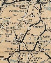
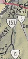
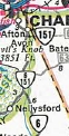
Also about 1935 (bridge date), VA 6 was removed from SR 737 west of Scottsville. About 1938, VA 6 west was truncated to VA 151 Nellysford. Nellysford to Afton became VA 151 which used SR 638 in the Avon area. In Apr 1949 (CTB), VA 6 was built onto new alignments in southwestern Albemarle County, leaving behind some abandoned routing but also SR 1809, SR 800, and SR 711. In Feb 1952 (CTB), VA 6 was removed from the James River Correctional Center leaving behind SR 645. The old loop eventually became today's VA 310. In Mar 1958 (CTB), VA 6 was removed from SR 810 between VA 151 and US 29. In Dec 1963 (CTB), VA 6 was re-extended along VA 151 to Avon, then extended northeast as new primary routing to US 250 Critzers Shop. In May 1965 (CTB), VA 6 was removed from SR 697/640 Cunningham Rd loop near Central Plains. In Oct 1967 (CTB), VA 6 was removed from SR 649/704 loop at Central Plains. In Oct 1971 (CTB), VA 6 was removed from SR 705 Cohassett Cir and the SR 612/671 loop at Cohassett. About 1980 (Bridgge date), VA 6 was put on its wrong-leg alignment at Woods Mill. The previous US 29 approach became today's VA 6Y. In Sep 1989 (CTB), VA 6 and VA 151 swapped routings north of Avon.
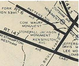
Improvements: Paved upon inception everywhere except from Scottsville west to US 29. VA 6 was paved from US 29 to VA 6Y Schuyler in 1936. VA 6 was paved from Scottsville west 3 miles in 1938. The rest of VA 6 was paved between 1942-44. VA 6 was first multilaned in 1960 or 1961 from Three Chopt Rd east to about where I-195 is now. In 1963, VA 6 was multilaned west to Parham Rd. In 1970, VA 6 was multilaned west to VA 157 In 1971, VA 6 was multilaned west to the Goochland line In 1975, VA 6 was multilaned west to Manakin. In 1979, VA 6 was multilaned on most of its US 29 duplex In 1980, VA 6 was multilaned on the rest of the US 29 duplex VA 7 is 6 or more lanes from US 15 to SR 7100 Fairfax County Pkwy Posted: Fully posted; Last known cutouts in Richmond replaced in 2018 The change from Patterson to Kensington is no longer posted. Amy Barden reported an error US 6 shield on WB US 250 on Afton Mtn in late 2004. This shield was corrected in 2008. There are VA 006 shields on business destination signs both directions on US 29 in Woods Mill Multiplexes: VA 151 (6.22 mi) US 29 (4.24 mi) VA 20 (0.58 mi) US 15 (1.99 mi) US 522 (1.74 mi) Legislative names: None Other names: Afton Mtn Rd (w of VA 151); River Rd (btw VA 151 and US 29); Thomas Nelson Hwy (US 29 duplex); Irish Rd (US 29 to VA 20); Valley Rd/Main St/Canal St (Scottsville); W. River Rd (Scottsville to US 15); James Madison Hwy (US 15 duplex); E. River Rd (US 15 to Columbia); St James St (Columbia); River Rd (Columbia to Manakin); Patterson Ave (Manakin to Richmond); Patterson Ave/Kensington Ave (Richmond) Scenic Byway: Entire route west of SR 650 Manakin. Comment: VA 6 is a very nice ride along the James River. VA 6 does not really traverse any populated areas and has no stoplights west of Goochland CH | Previous VA 6's:
1922 ROUTE LOG VA 1: 0 - 0 VA 21 EB: 8 - 8 VA 25 EB: 6 - 14 VA 21 WB, VA 25 WB: 1 - 15 VA 2 NB: 18 - 33 VA 2 SB: 6 - 39 VA 7 SB: 28 - 67 VA 3: 1 - 68 WV STATE LINE: 17 - 85 |
VA 6 #1: Began in January 1918 as an original state route defined by the general assembly:
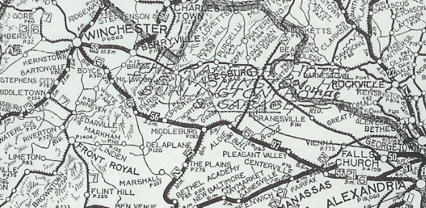
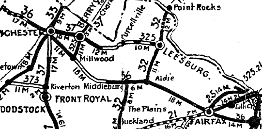
Route 6: Alexandria, Fairfax, Aldie, Middleburg, Upperville, Boyce, Winchester, Gore, West Virginia Line More specifically, VA 6 began at VA 1 (most likely now VA 400) Alexandria, using VA 236 west to Fairfax. Here VA 6 headed west on US 50 to Middleburg, then used SR 828 loop through Atoka, then crossed over US 50 and crossed Goose Creek near the north end of SR 624. VA 6 picked back up US 50 through Upperville toward Paris, where it used Federal St through the village.
|
|||||||||||||||
Previous: VA 5 |
Next: VA 6Y | VA 7
Top | Virginia Hwy Index
Home
Page last modified 22 December 2023