< VA 6 | Home | VA 7 Bus | VA 7 SPUR | VA 7X | VA 7Y | VA 8 >
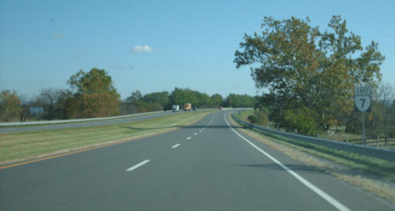
Photo: VA 7 on the Berryville Bypass (photo by Mapmikey 10/23/08)
|
|
|
| ROUTE LOG |
US 50 WB: 0 - 0 US 11 SB, US 50 EB, US 522 SB: 0.18 - 0.18 US 11 NB, US 522 NB: 0.17 - 0.35 I-81 (exit 315): 1.47 - 1.82 Frederick-Winchester Line: 0 - 1.82 Clarke-Frederick Line: 3.69 - 5.51 VA 7 Bus: 3.80 - 9.31 US 340: 1.45 - 10.76 VA 7 Bus: 1.65 - 12.41 Loudoun-Clarke Line: 6.67 - 19.08 VA 7 Bus: 3.91 - 22.99 VA 7 Bus: 1.07 - 24.06 VA 287: 4.05 - 28.11 VA 7 Bus, VA 9: 4.44 - 32.55 VA 7 Bus: 2.38 - 34.93 US 15 SB, US 15 Bus: 1.85 - 36.78 VA 267: 0.44 - 37.22 US 15 NB, VA 7 Bus: 1.16 - 38.38 VA 28: 5.37 - 43.75 VA 391: 2.57 - 46.32 VA 228: 1.50 - 47.82 Fairfax-Loudoun Line: 0 - 47.82 VA 193: 1.69 - 49.51 VA 267: 7.26 - 56.77 VA 123: 1.15 - 57.92 I-495 (exit 47): 0.91 - 58.83 I-66 (exit 66): 1.30 - 60.13 Falls Church-Fairfax Line: 0.65 - 60.78 US 29, VA 237: 1.31 - 62.09 Fairfax-Falls Church Line: 1.27 - 63.36 VA 338: 0.18 - 63.54 US 50: 0.05 - 63.59 VA 244: 2.07 - 65.66 Alexandria-Fairfax Line: 1.15 - 66.81 I-395 (exit 5): 1.09 - 67.90 VA 402: 0.65 - 68.55 VA 420: 1.40 - 69.95 US 1: 1.27 - 71.22 VA 400: 0.10 - 71.32
|
|
Creation: Appeared in July 1933 as a renumbering of:
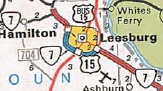
In March 1948 (CTB), VA 7 was removed from SR 743 Colvin Run Rd east of Dranesville Between 1965-70, VA 7 was removed from SR 653 Golf Creek Rd and the demolished bridge over Goose Creek east of Leesburg About 1973, VA 7 was placed on a new freeway bypass north of Berryville, leaving behind VA 7 Business. In March 1974 (CTB), VA 7 was placed on new alignment on the western side of Snickers Gap, leaving behind SR 679. In Sept 1975 (CTB), VA 7 was placed on a new freeway bypass of Leesburg, some of which had opened earlier as US 15 Bypass. This left behind VA 7 Business through Leesburg.
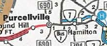
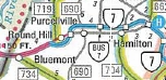
In Aug 1980 (CTB), VA 7 was placed on a new Super-2 bypass of Hamilton. VA 7 then used VA 287 south to the original route 7. The highway between VA 287 and VA 9 became VA 7 Business. In Nov 1987 (CTB), VA 7 was placed on more new Super-2 freeway bypassing Purcellville and Round Hill, leaving behind a bit of VA 287 and an extended VA 7 Business.
Improvements: Paved upon inception everywhere except from Nain to West Virginia. The rest of VA 7 was paved in 1936. VA 7 was first multilaned in 1954, from US 50 to Alexandria line except right around Baileys Crossroads. In 1955, VA 7 was multilaned around VA 244 Bailey Crossroads. In 1957, VA 7 was multilaned from the Fairfax-Alexandria line to today's VA 402. In 1960 or 1961, VA 7 was multilaned from VA 402 to about VA 420; also from US 29 to US 50. In 1966, VA 7 was multilaned from VA 123 to I-495. In 1968, VA 7 was multilaned from I-495 to I-66. In 1969, VA 7 was multilaned from I-66 to US 29; also from VA 228 east to VA 267. In 1970, VA 7 was multilaned from I-81 to Clarke County. In 1971, VA 7 was multilaned from Clarke-Frederick line east halfway to Berryville; also from US 15 Bypass to VA 228. The 1972 Official shows VA 7 mutlilaned from Clarke SR 612 east to Snickers Gap. In 1973, VA 7 was multilaned on the Berryville Bypass. In 1975, VA 7 was multilaned on the Leesburg Bypass; also from Snickers Gap to about Round Hill. In 1976, VA 7 was multilaned from VA 9 east to Leesburg Bypass. In 1993 or 1994, VA 7 was multilaned from I-81 west to Pleasant Valley Rd. About 1995, VA 7 was multilaned from VA 9 west past Round Hill. Between 1989-95, VA 7 was 6-laned from SR 1345 City Center Blvd to VA 228 Between 1996-2002, VA 7 was 6-laned between US 15 and SR 1345 City Center Blvd; also from VA 228 to Dranesville Manor Dr. In 2016, VA 7 was 6-laned from Dranesville Manor Dr to Reston Rd In 2023, VA 7 was 6-laned from Reston Rd to Tysons Corner New interchanges have been built in recent years between Leesburg and VA 28 at River Creek Pkwy (SR 773) and Loudoun County Pkwy (SR 607). The only remaining 2-lane segments of VA 7 are the westernmost 3/4-mile in Winchester and the easternmost mile-and-a-half in Alexandria. VA 7 is 6 or more lanes from US 15 to SR 7100 Fairfax County Pkwy and again in the Tysons Corner area from the Dulles Toll Rd (VA 267) to I-495. Posted: Fully posted except at its easternmost end; Most cutouts in Winchester were replaced in the early 2010s (a set on Pleasant Valley Dr was still up in 2023) and Falls Church has one set remaining at US 29 in Falls Church as of 2023. 3 I-7 Bus shields existed on SR 641 near Ashburn for a time; an error US 7 sign existed at the US 340 interchange in the late 90s (gone now); A square 7 shield (like the Massachusetts state highway marker) existed for several years near the Masonic temple in Alexandria (since replaced with a flat top Interstate-style shield); a couple SR 7 shields exist in the Tysons Corner shopping area. Multiplexes: US 50 (0.18 mi) US 11, US 522 (0.17 mi) US 15 (1.60 mi) Legislative names: Harry Flood Byrd Highway (entire route except the Bypass portions), since 11-21-68; Robert W Smalley Memorial Bridges at Castleman's Ferry, over the Shenandoah River (since 3-7-95) Other names: Piccadilly St/East Ln/National Ave/Berryville Pike (Winchester); Leesburg Bypass/Market St (Leesburg); Leesburg Pike (Fairfax Co); Broad St (Falls Church); King St (Alexandria) Scenic Byway: No segments Comments: VA 7 is shown to be on one-way splits in downtown Winchester: westbound VA 7 follows Piccadilly St until its intersection with Braddock St (SB US 11/522) then south to Boscawen St (US 50). Eastbound VA 7 follows Boscawen St to Cameron St (NB US 11/522) then north to Piccadilly St. VA 7 is a major commuter route in Northern Virginia all the way out to Winchester. It is clogged for large parts of the day everywhere east of Purcellville, especially in western Fairfax County, near Tysons Corner, and in Old Town Alexandria. One could argue it is important enough to be an extended US 48 or swapped with US 50. | Previous VA 7's:
1922 ROUTE LOG BEGIN VA 7: 0 - 0 VA 7X: 61 - 61 VA 7Y: 8 - 69 VA 1 NB: 32 - 101 VA 1 SB, VA 8: 2 - 103 VA 2 SB: 35 - 138 VA 2 NB: 2 - 140 VA 21: 26 - 166 VA 3 SB: 30 - 196 VA 3 NB, VA 6 EB: 10 - 206 WV STATE LINE: 17 - 223 |
VA 7 #1: Began in January 1918 as an original state route defined by the general assembly:
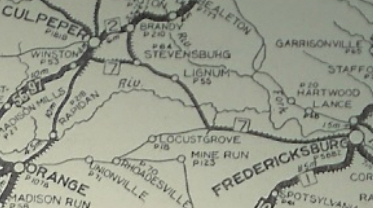
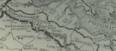
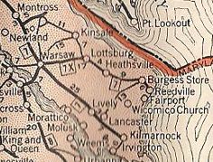
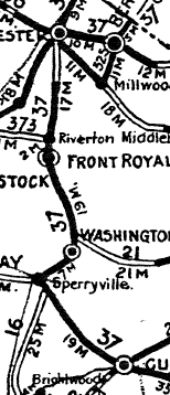
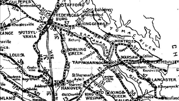
Route 7: Reedsville [sic] and Irvington, Heathsville, Warsaw, Montross, King George CH, Fredericksburg, Stevensburg, Culpeper, Washington (VA), Front Royal, Winchester, West Virginia Line
More specifically, VA 7 began at Irvington, using VA 200 north to Pittmans Corner. Here VA 7 cut west on SR 646 to Christ Church, then north on VA 222 back to VA 200 and over to Kilmarnock. VA 7 picked up today's VA 3 through Brookvale to Lancaster (used SR 790 at Camps Millpond). VA 7 then used SR 600 to McNeals Coner, then VA 201Y and VA 201 to Lively.
In May 1920 (CTB), VA 7 was rerouted to use today's VA 3 from Stevensburg to Chancellorsville.
|
|||||||||||||||||||

Previous: VA 6 |
Next: VA 7 Bus | VA 7 SPUR | VA 7X | VA 7Y | VA 8
Top | Virginia Hwy Index
Home
Page last modified 6 January 2024