|
From:  City of Richmond City of Richmond
To:
 City of Williamsburg City of Williamsburg
Current Length: 54.96 miles
|
|
|
|
|
ROUTE LOG
US 60 WB: 0 - 0
US 60 EB: 0.30 - 0.30
Henrico-Richmond Line: 0.66 - 0.96
VA 895 ALT: 4.12 - 5.08
I-295 (exit 22): 3.27 - 8.35
VA 156 NB: 4.70 - 13.05
Charles City-Henrico Line: 1.72 - 14.77
VA 106, VA 156 SB: 4.34 - 19.11
VA 155: 9.37 - 28.48
James City-Charles City Line: 13.28 - 41.76
VA 199 NB: 8.19 - 49.95
Williamsburg-James City Line: 0.22 - 50.17
VA 31, VA 199 SB: 0.24 - 50.41
VA 132 SB: 1.93 - 52.34
VA 132 NB: 0.38 - 52.72
US 60 EB: 1.06 - 53.78
US 60 WB: 0.56 - 54.34
VA 143: 0.62 - 54.96
|
|
Creation: Appeared in July 1933 as a renumbering of:
VA 835 from Monterey to Hightown
VA 39 from Keswick to Monterey
VA 41 from Williamsburg to Keswick .
This is the 2nd VA 5.
Here is a detailed look from east to west:
VA 5 began at VA 31 (Jamestown Rd at John Tyler Ln) williamsburg. It used J Tyler Ln west to current VA 5-199, then followed current VA 5 to the Chickahominy River. There was no bridge then, so VA 5 used Barretts Ferry Rd to the ferry across the river.
In Charles City County, VA 5 used current 5 to Henrico County, except it used SR 645 at the ferry landing; SR 644 Courthouse Rd loop at Charles City C.H.; SR 640/633 loop near Berkeley Plantation
In Henrico County, VA 5 followed current VA 5 until it reached New Osborne Tpk. VA 5 initially followed New Osbourne Tpk , Newton Rd, Hatcher St, Williamsburg Ave, Fulton St (now stops at Hobbs Ln). VA 5 continued north across Stony Run Rd, the stream, and thr RR tracks, before curling west around a loop up the hill to connect with Government Rd (then-US 60) at 36th St. An old bridge used by VA 5 is still visible looking south from US 60 Stony Run Rd. VA 5 then followed Broad St all the way through Richmond.
West of Richmond, VA 5 followed today's US 250 to Albemarle County except: SR 653 loop near Ferncliff; SR 696 loop west of Ferncliff; SR 607 loop in and out of Fluvanna County; abandoned loop over to US 15; SR 615 to Zionand SR 627 SW back to US 250; SR 759 loop near Boyds Tavern; SR 616 to Keswick; VA 22 to Shadwell.
VA 5 picked up US 250 at Shadwell, then US 250 Business to Charlottesville. VA 5 used High St to Park Ave to Jefferson St. Here VA 5 split into one-way splits: WB used Jefferson and 2nd to Main, while EB used Main and 5th St to Jefferson.
Heading west of Charlottesville, VA 5 used US 250 Bus west out of town along with SR 601 Old Ivy Rd. and SR 754. VA 5 then used SR 738 /739/786 and more abandoned routing north of US 250. VA 5 then used VA 240 through Crozet, and picked back up US 250. VA 39 used SR 797 through Yancey Mills (now cutoff by I-64). VA 5 used US 250, then SR 796 loop near VA 151. VA 5 then used SR 750 Old Turnpike Rd to ascend to Afton.
VA 5 used VA 6 across the railroad and up to US 250. VA 5 followed US 250's corridor to descend to Waynesboro (several old alignments are evident). VA 5 used a couple brief loops down to Waynesboro, then US 340 Main St through downtown. VA 5 picked back up US 250 through Fishersville.
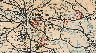
VA 5 Williamsburg to Richmond
1933 Official
|
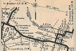
VA 5 in Charlottesville
1933 Official
|
It appears VA 5 followed US 250 into Staunton but used Main to Central north back to current US 250. VA 5 used Old Churchville Rd out towards VA 262. VA 5 used US 250, then SR 840, then SR 721 south where VA 5 crossed the Middle River in line with SR 722 which VA 5 followed north back to 250 then west to Churchville.
VA 5 followed US 250 through Monterey to Hightown.
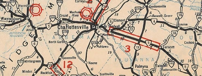
VA 5 Richmond to Staunton
1933 Official
|
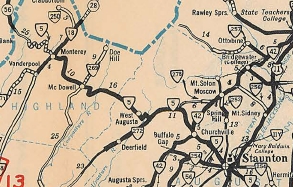
VA 5 Staunton to West Virginia
1933 Official
|
Adjustments: In Aug 1933 (CTB), VA 5 was extended from Hightown to West Virginia.
In Mar 1934 (CTB), VA 5 was placed on today's US 250 from SR 616 Boyd's Tavern all through Louisa and Fluvanna Counties.
In 1935, VA 5 was renumbered as US 250 from Richmond to West Virginia.
In Oct 1938 (CTB), VA 5 was removed from SR 645 and Barretts Ferry Rd as a new bridge over Chickahominy River opened.
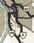
In March 1949 (CTB), VA 5 was given its current corridor approaching Richmond from the east replacing VA 146, then using 25th St over to Broad St. Based on this 1960 picture, VA 5 was still signed along Broad (presumably to where US 250 began at 2nd St) until at least 1960. My guess is this remained signed on Broad St until US 250 was extended east along Broad in 1974. The old alignment up to Williamsburg Rd became part of VA 146.
VA 5 initial route
1944 Official
|
VA 5 swaps with VA 146
1950 Official
|
In Nov 1953 (CTB), VA 5 was removed from the SR 640/633 loop near Berkeley Plantation.
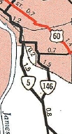
By 1955 (possibly as part of the March 1949 action), VA 5 west was extended to at least US 360. Here is an Oct 1955 photo of VA 5 cosigned with US 60 and VA 33 west of 21st St. No VDOT map I've seen yet shows this but it did appear on General Drafting maps.
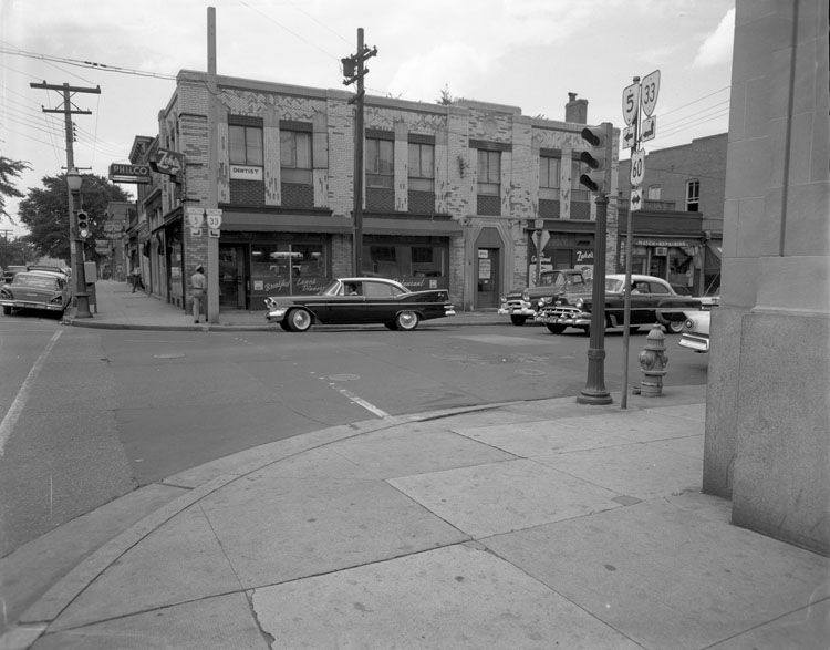
Broad St west at 11th, VA 5 and VA 33 join US 60.
photo by Adolph Rice, 1960
|
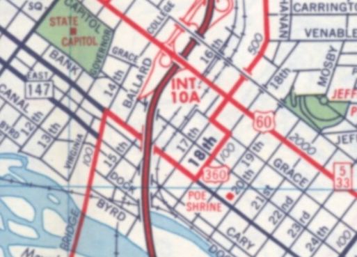
VA 5 and VA 33 shown on Broad St west to at least US 360.
1962 Gen Draft
|
In March 1956 (CTB), VA 5 was removed from the SR 644 loop at Charles City C.H.
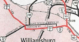
In Aug 1958 (CTB), VA 5 was extended east with VA 31 through Williamsburg to its end at VA 168 (now VA 143), using Jamestown Rd to Henry St to Francis St to US 60.
By 1972, VA 5 west was truncated to 25th and Broad.
In June 1973 (CTB), VA 5 was rerouted in central Williamsburg to follow Duke of Gloucester St, Henry St, LaFayette St and York St to US 60. Francis St became unnumbered.
In July 1974 (CTB), VA 5 was removed from Duke of Gloucester St (permanently closed to vehicles) and instead used Boundary south to Francis east to Henry (as it runs today).
In March 1976 (CTB), VA 5 was removed from John Tyler Ln east of VA 199 and instead placed on VA 199 and VA 31.
VA 5 extended with VA 31
1959 Official
|
VA 5 moved to Lafayette
1976 Official
|
In Nov 1983 (CTB), VA 5 was removed from Old Main St/Orleans St in Richmond.
In Sept 2003 (CTB), VA 5 was removed from 25th St to its current ending on Main St at 25th.
Improvements: Paved upon inception everywhere except from Monterey westward; Keswick to Goochland County; 3 miles east and west of Barretts Ferry.
VA 5 was paved from Boyd's Tavern to Goochland County in 1934.
The rest of VA 5 was paved in 1937.
VA 5 was first multilaned in 1958 when it was placed on its US 60 duplex in Williamsburg.
In 1960 or 1961, VA 5 was multilaned in Williamsburg from College Creek to US 60; also from US 60 northeast to VA 168.
In 1974, VA 5 was multilaned from College Creek south to J Tyler Lane; VA 5's new route across Williamsburg to US 60 was not multilaned.
In 1976, VA 5 was multilaned when placed on VA 199 and VA 31.
In 1987, VA 5 was multilaned around the I-295 interchange area.
VA 5 is multilaned on its US 60 duplex in Richmond. It is not shown on maps but I think it has been this way a long time.
Posted: Fully posted; cutouts in Richmond removed in early 2000s.
Multiplexes: US 60 (0.30 mi)
VA 156 (6.06 mi)
VA 199 (0.46 mi)
VA 31 (0.38 mi)
US 60 (0.56 mi)
Legislative names: John Tyler Memorial Highway, from Richmond to VA 31 (since 3-26-36); Powhatan Beaty Memorial Bridge over VA 895 (since 4-4-00); Chickahominy Bridge (since 3-24-40); Judith Stewart dresser Memorial Bridge over Chickahominy River (since 3-16-03)
Other names: Main St (Richmond); Old Osborne Tpk/New Market Rd (Henrico Co); Jamestown Rd/Boundary St/Francis St/Henry St/Lafayette St/York St/Page St/Capitol Landing Rd (Williamsburg)
Scenic Byway: Richmond ECL to Williamsburg WCL since 8-21-75.
Comment: VA 5 runs through an industrial part of Richmond, then quickly exits into rural, then forested areas near several plantations along the James River.
VA 5 runs very near parts of Colonial Williamsburg.
|
| Previous VA 5's:
1922 ROUTE LOG
VA 10, VA 12 EB: 0 - 0
VA 12W: 23.5 - 23.5
VA 10 WB: 0.5 - 24
VA 12Y: 20 - 44
VA 12 WB: 10 - 54
VA 10 EB: 47 - 101
VA 1 SBVA 10 WB: 1 - 102
VA 13 WB: 23 - 125
VA 1 NB, VA 13 EB: 1 - 126
|
|
|
VA 5 #1: Began in January 1918 as an original state route defined by the general assembly:
Route 5: Norfolk, Suffolk, Franklin, Courtland, Petersburg, Richmond
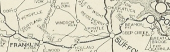
It is difficult to say where VA 5 began in Norfolk. VA 5 headed south on Bank St (with then VA 10 and VA 12) to the Elizabeth River Ferry. On the Portsmouth side, VA 5 used Queen St west, Water St north, then London St and 1st St before picking up High St west to 6th St to then-Suffolk Rd (now VA 337 ALT) out of town.
VA 5 followed today's VA 337 through Suffolk, where VA 10 branched off to the north. VA 5 (with VA 12 still) followed today's US 58 except: US 58 Business routes through western Suffolk and Holland; In Franklin, VA 5 used 2nd Ave, Main St, 4th Ave and Clay St instead of the complete 58 Business routing today; US 58 Business into Courtland (except it used Linden St and SR 611 Rochelle St), where VA 12 branched off to the west.
Finally, VA 5 went off on its own routing, following VA 35 north to Templeton except: SRs 616/727 north of Courtland; SRs 713/719/653 around Sebrell), US 301 north into Petersburg (not 301 ALT), then used Wythe St west to Sycamore north. VA 5 then joined forces with VA 1 (now US 1-301) to Richmond except it used SR 1625 in the VA 145 area and it used the Hull St bridge to cross the James River. VA 5 then headed west on Main and I presume VA 5 ended at the Capitol.
The VA 5 routing outside the cities is taken from 1919 and 1920 Topo Maps along its path. The city routings are drawn from the 1923 Auto Trails Map Insets.
The 1923 Official shows the route corridor paved from Littleton to Norfolk, so VA 5 was removed from SR 616/727 near Courtland and also SR 719/653 near Sebrell.
In May 1923, VA 5 was renumbered as VA 35 from Richmond to Petersburg; VA 35 from Petersburg to Courtland; VA 12 remained from Courtland to Suffolk; VA 10 remained from Suffolk to Norfolk.
|
1922 Auto Trails
|
Original VA 5
1922 Auto Trails
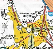
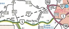
VA 5 ALT: Appeared on the 2000 Official as a route under construction west of Williamsburg to connect VA 5 near CR 614 to VA 199 near VA 321/CR 615.
When the road opened, it actually became SR 5000 and a small part of VA 321.
|
VA 5 ALT proposed near Williamsburg
2000 Official
|
|