< VA 800 to 825 | Home | VA 1 to 6 >
Photo: VA 895 transitioning to VA 150 (photo by Mapmikey 4/24/07)
| VA 826 not currently assigned | |||||||||||||||||||||||||||||||||||||||||||||||||||||||||||||||||||||||||||||||||||||||||||||||||||||||||||||||||||||||||||||||||||||||||
| Previous VA 826's: 1932 ROUTE LOG VA 54: 0 - 0 VA 251: 0.10 - 0.10 |
VA 826: Appeared in August 1928 replacing VA 376 which ran the one block of Main St in Berryville between VA 54 (now US 340/VA 7 Bus jct) and VA 251 (now VA 7 Bus/SR 616 jct).
In July 1933, VA 826 was renumbered as part of VA 7. Today it is part of VA 7 Business. VA 826 is shown only in the 1931 VDOT Route Log. it does not appear on any VDOT Official or in the 1932 Clarke County map. |
||||||||||||||||||||||||||||||||||||||||||||||||||||||||||||||||||||||||||||||||||||||||||||||||||||||||||||||||||||||||||||||||||||||||
| VA 827 not currently assigned | |||||||||||||||||||||||||||||||||||||||||||||||||||||||||||||||||||||||||||||||||||||||||||||||||||||||||||||||||||||||||||||||||||||||||
| Previous VA 827's: 1932 ROUTE LOG VA 822: 0 - 0 WV STATE LINE: 8.92 - 8.92 |
|
||||||||||||||||||||||||||||||||||||||||||||||||||||||||||||||||||||||||||||||||||||||||||||||||||||||||||||||||||||||||||||||||||||||||
| VA 828 not currently assigned | |||||||||||||||||||||||||||||||||||||||||||||||||||||||||||||||||||||||||||||||||||||||||||||||||||||||||||||||||||||||||||||||||||||||||
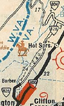
| Previous VA 828's: 1932 ROUTE LOG VA 800: 0 - 0 Bath-Alleghany Line: 12.50 - 12.50 CR 3: 11.28 - 23.78 |
|
||||||||||||||||||||||||||||||||||||||||||||||||||||||||||||||||||||||||||||||||||||||||||||||||||||||||||||||||||||||||||||||||||||||||
| VA 829 not currently assigned | |||||||||||||||||||||||||||||||||||||||||||||||||||||||||||||||||||||||||||||||||||||||||||||||||||||||||||||||||||||||||||||||||||||||||
| Previous VA 829's: 1932 ROUTE LOG VA 39: 0 - 0 CR 5: 7.61 - 7.61 |
|
||||||||||||||||||||||||||||||||||||||||||||||||||||||||||||||||||||||||||||||||||||||||||||||||||||||||||||||||||||||||||||||||||||||||

| VA 830 not currently assigned | |||||||||||||||||||||||||||||||||||||||||||||||||||||||||||||||||||||||||||||||||||||||||||||||||||||||||||||||||||||||||||||||||||||||||
| Previous VA 830's: 1932 ROUTE LOG VA 17: 0 - 0 CR 6: 4.90 - 4.90 |
|
||||||||||||||||||||||||||||||||||||||||||||||||||||||||||||||||||||||||||||||||||||||||||||||||||||||||||||||||||||||||||||||||||||||||
| VA 831 not currently assigned | |||||||||||||||||||||||||||||||||||||||||||||||||||||||||||||||||||||||||||||||||||||||||||||||||||||||||||||||||||||||||||||||||||||||||
| Previous VA 831's: 1932 ROUTE LOG US 11, VA 33, VA 39: 0 - 0 VA 39: 15 - 15 |
|
||||||||||||||||||||||||||||||||||||||||||||||||||||||||||||||||||||||||||||||||||||||||||||||||||||||||||||||||||||||||||||||||||||||||
| VA 832 not currently assigned | |||||||||||||||||||||||||||||||||||||||||||||||||||||||||||||||||||||||||||||||||||||||||||||||||||||||||||||||||||||||||||||||||||||||||
| Previous VA 832's: 1932 ROUTE LOG VA 809: 0 - 0 VA 39: 4.33 - 4.33 |
|
||||||||||||||||||||||||||||||||||||||||||||||||||||||||||||||||||||||||||||||||||||||||||||||||||||||||||||||||||||||||||||||||||||||||
| VA 833 not currently assigned | |||||||||||||||||||||||||||||||||||||||||||||||||||||||||||||||||||||||||||||||||||||||||||||||||||||||||||||||||||||||||||||||||||||||||
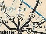
| Previous VA 833's: 1932 ROUTE LOG US 11, VA 33: 0 - 0 Clarke-Frederick Line: 3.16 - 3.16 WV STATE LINE: 4.33 - 7.49 |
|
||||||||||||||||||||||||||||||||||||||||||||||||||||||||||||||||||||||||||||||||||||||||||||||||||||||||||||||||||||||||||||||||||||||||
| VA 834 not currently assigned | |||||||||||||||||||||||||||||||||||||||||||||||||||||||||||||||||||||||||||||||||||||||||||||||||||||||||||||||||||||||||||||||||||||||||
| Previous VA 834's: 1932 ROUTE LOG US 50, VA 36: 0 - 0 WV STATE LINE: 4.10 - 4.10 |
|
||||||||||||||||||||||||||||||||||||||||||||||||||||||||||||||||||||||||||||||||||||||||||||||||||||||||||||||||||||||||||||||||||||||||
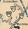
| VA 835 not currently assigned | |||||||||||||||||||||||||||||||||||||||||||||||||||||||||||||||||||||||||||||||||||||||||||||||||||||||||||||||||||||||||||||||||||||||||
| Previous VA 835's: 1932 ROUTE LOG VA 39, VA 800: 0 - 0 CR 4: 7.86 - 7.86 |
|
||||||||||||||||||||||||||||||||||||||||||||||||||||||||||||||||||||||||||||||||||||||||||||||||||||||||||||||||||||||||||||||||||||||||
| VA 836 not currently assigned | |||||||||||||||||||||||||||||||||||||||||||||||||||||||||||||||||||||||||||||||||||||||||||||||||||||||||||||||||||||||||||||||||||||||||
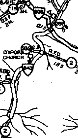
| Previous VA 836's: 1932 ROUTE LOG VA 815: 0 - 0 VA 842: 10.75 - 10.75 US 211, VA 21: 1.30 - 12.05 |
|
||||||||||||||||||||||||||||||||||||||||||||||||||||||||||||||||||||||||||||||||||||||||||||||||||||||||||||||||||||||||||||||||||||||||
| VA 837 not currently assigned | |||||||||||||||||||||||||||||||||||||||||||||||||||||||||||||||||||||||||||||||||||||||||||||||||||||||||||||||||||||||||||||||||||||||||
| Previous VA 837's: 1931 ROUTE LOG US 60, VA 14: 0 - 0 CR 2: 0.41 - 0.41 |
|
||||||||||||||||||||||||||||||||||||||||||||||||||||||||||||||||||||||||||||||||||||||||||||||||||||||||||||||||||||||||||||||||||||||||
| VA 838 not currently assigned | |||||||||||||||||||||||||||||||||||||||||||||||||||||||||||||||||||||||||||||||||||||||||||||||||||||||||||||||||||||||||||||||||||||||||
| Previous VA 838's: 1932 ROUTE LOG VA 17: 0 - 0 US 11, VA 33: 2.30 - 2.30 CR 35: 3.05 - 5.35 |
|
||||||||||||||||||||||||||||||||||||||||||||||||||||||||||||||||||||||||||||||||||||||||||||||||||||||||||||||||||||||||||||||||||||||||
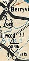
| VA 839 not currently assigned | |||||||||||||||||||||||||||||||||||||||||||||||||||||||||||||||||||||||||||||||||||||||||||||||||||||||||||||||||||||||||||||||||||||||||
| Previous VA 839's: 1932 ROUTE LOG US 50, VA 36: 0 - 0 CR 14: 2.00 - 2.00 GAP IN ROUTE VA 54: 0 - 2.00 CR 3: 3.80 - 5.80 |
VA 839: Appeared in June 1931 as an upgrade to CR 14, running from US 50/VA 36 east of the Shenandoah River north 2.00 miles.
In July 1932 (CTB), A second piece of VA 839 was created as an upgrade to CR 3, running from VA 54 (now VA 7) east of Berryville to just short of US 340/VA 37 Gaylord. In July 1933, the southern (original) piece of VA 839 became VA 276 (now SR 602). The northern piece became VA 282 (now SR 608 and SR 612).
|
||||||||||||||||||||||||||||||||||||||||||||||||||||||||||||||||||||||||||||||||||||||||||||||||||||||||||||||||||||||||||||||||||||||||
| VA 840 not currently assigned | |||||||||||||||||||||||||||||||||||||||||||||||||||||||||||||||||||||||||||||||||||||||||||||||||||||||||||||||||||||||||||||||||||||||||
| Previous VA 840's: 1932 ROUTE LOG VA 17: 0 - 0 CR 101: 2.36 - 2.36 |
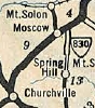
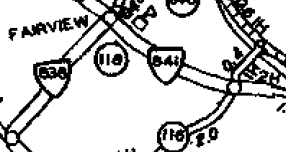
VA 840: Appeared in July 1932 (CTB) as an upgrade to CRs 102 and 101, running from VA 17 (now VA 42) Stover Shop 2.36 miles towards VA 39 (now US 250).
In July 1933, VA 840 became VA 278. Today it is SR 728. VA 840 is not shown on officials or the 1932 Augusta County map. |
||||||||||||||||||||||||||||||||||||||||||||||||||||||||||||||||||||||||||||||||||||||||||||||||||||||||||||||||||||||||||||||||||||||||
| VA 841 not currently assigned | |||||||||||||||||||||||||||||||||||||||||||||||||||||||||||||||||||||||||||||||||||||||||||||||||||||||||||||||||||||||||||||||||||||||||
| Previous VA 841's: 1932 ROUTE LOG VA 836: 0 - 0 CR 119: 1.49 - 1.49 |
|
||||||||||||||||||||||||||||||||||||||||||||||||||||||||||||||||||||||||||||||||||||||||||||||||||||||||||||||||||||||||||||||||||||||||
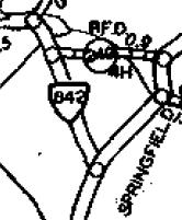
| VA 842 not currently assigned | |||||||||||||||||||||||||||||||||||||||||||||||||||||||||||||||||||||||||||||||||||||||||||||||||||||||||||||||||||||||||||||||||||||||||
| Previous VA 842's: 1932 ROUTE LOG VA 815: 0 - 0 CR 13: 1.50 - 1.50 |
|
||||||||||||||||||||||||||||||||||||||||||||||||||||||||||||||||||||||||||||||||||||||||||||||||||||||||||||||||||||||||||||||||||||||||
| VA 843 not currently assigned | |||||||||||||||||||||||||||||||||||||||||||||||||||||||||||||||||||||||||||||||||||||||||||||||||||||||||||||||||||||||||||||||||||||||||
| Previous VA 843's: 1932 ROUTE LOG VA 806: 0 - 0 END VA 843: 3.10 - 3.10 |
|
||||||||||||||||||||||||||||||||||||||||||||||||||||||||||||||||||||||||||||||||||||||||||||||||||||||||||||||||||||||||||||||||||||||||
| VA 844 not currently assigned | |||||||||||||||||||||||||||||||||||||||||||||||||||||||||||||||||||||||||||||||||||||||||||||||||||||||||||||||||||||||||||||||||||||||||
| Previous VA 844's: 1932 ROUTE LOG VA 817: 0 - 0 CR 128-129: 2.00 - 2.00 |
|
||||||||||||||||||||||||||||||||||||||||||||||||||||||||||||||||||||||||||||||||||||||||||||||||||||||||||||||||||||||||||||||||||||||||
| VA 845 not currently assigned | |||||||||||||||||||||||||||||||||||||||||||||||||||||||||||||||||||||||||||||||||||||||||||||||||||||||||||||||||||||||||||||||||||||||||
| Previous VA 845's: 1932 ROUTE LOG VA 820: 0 - 0 CR 18: 1.00 - 1.00 |
|
||||||||||||||||||||||||||||||||||||||||||||||||||||||||||||||||||||||||||||||||||||||||||||||||||||||||||||||||||||||||||||||||||||||||
| I-864 |
| I-895 |
|
|
|
| ROUTE LOG |
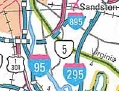
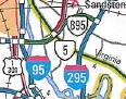
I-95 (exit 67), VA 150: 0 - 0 Henrico-Chesterfield Line: 0.64 - 0.64 VA 895 ALT: 2.22 - 2.86 I-295 (exit 25): 5.66 - 8.52
|
Creation: Opened as a new freeway in May 2002. This is the only VA 895.
|
Adjustments: None Improvements: 4-lanes at inception. Posted: Fully posted. Multiplexes: None Legislative names: Pocahontas Parkway (since 1/21/99) Other names: None Scenic Byway: No segments Comment: VA 895 is a toll road that was shown on Officials from 1996-2000 as I-895. See the I-895 entry for what happened here. The road opened as VA 895. Might as well have made it an extended VA 150 if they weren't going to make it an interstate. More detailed information on VA 895 can be found on Scott Kozel's website.
| ||||||||||||||||||||||||||||||||||||||||||||||||||||||||||||||||||||||||||||||||||||||||||||||||||||||||||||||||||||||||||||||||||