< VA 29 | Home | VA 31 >
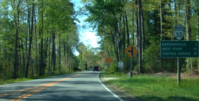
Photo: VA 30 leaving I-64 Exit 227 (photo by Mapmikey 4/23/09)
|
.
|
|
| ROUTE LOG |
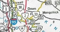
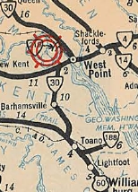
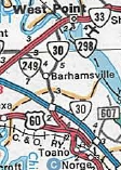
US 1: 0 - 0 I-95 (exit 98): 0.61 - 0.61 Caroline-Hanover Line: 1.59 - 2.20 US 301, VA 2: 3.47 - 5.67 King William-Caroline Line: 3.18 - 8.85 US 360: 12.12 - 20.97 VA 33 EB: 24.54 - 45.51 VA 296: 0.10 - 45.61 New Kent-King William Line: 0.15 - 45.76 VA 273: 0.75 - 46.51 VA 33 WB, VA 249: 3.90 - 50.41 VA 273: 3.43 - 53.84 James City-New Kent Line: 0.78 - 54.62 I-64 (exit 227): 2.13 - 56.75 US 60: 1.71 - 58.46 I-64 (exit 231): 3.41 - 61.87
|
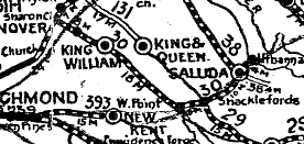
Creation: Appeared in 1923 as a renumbering of VA 9Z from VA 13 (now SR 662) Central Garage to just short of Urbanna via West Point. This is the only VA 30.
| In Aug 1928 (CTB), VA 30 was extended east 0.5 miles to Urbanna; also, VA 30 was extended east with VA 13 from Central Garage a short distance, then west 9.8 miles as new routing.
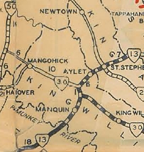
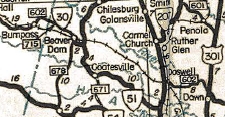
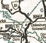
In Dec 1930 (CTB), VA 30 was extended west 3 more miles to Mangohick. In July 1932 (CTB), VA 30 was extended west to VA 50 (now SR 651) Dawn. About 1932, VA 30 was removed from SRs 636 at Port Richmond; 625/634Beatons Ln; 627 St Johns Church Rd; abandoned routing/Episcopal Ln in the SR 630 Churchville Rd area; 620 Black Gum Rd; SR 1301 King William CH; 617 Spring Forest Rd In July 1933, VA 30 from West Point to Stormont was renumbered as part of VA 4 and from there to Urbanna it became VA 227. Today this is VA 33; F1000; VA 33 to Glenns except: SR 678 at Shacklefords, SR 601, SR 679, SR 647; VA 33 to Saluda; SR 629/641 in Stormont; VA 227 except SR 1004 just across Urbanna Creek. Instead, VA 30 was extended west across the Pamunkey River with then-VA 4, then replaced VA 53 south to US 60 Anderson's Corner. Also in July 1933, VA 30 was assigned to a separate piece of road from VA 51 (now SR 738) west throguh Beaverdam to the Louisa County line, replacing VA 428. In Aug 1933 (CTB), the original piece of VA 30 was extended north along today's SR 651 in Dawn to meet the rerouted VA 2. This replaced what had been a piece of VA 2. In Feb 1937 (CTB), VA 30 was removed from SR 644 Olde Footpath Rd near Mangohick. In May 1937 (CTB), VA 30 was removed from SR 650 Winston Loop. The 1937 Official map seems to show VA 30 was removed from SR 651 plus some abandoned routing south of SR 694 in Dawn and put on a short new segment west to US 301/VA 2. In Jan 1941 (CTB), VA 30 was removed from SR 604 (now SR 671) at Mangohick. In May 1943 (CTB), the western piece of VA 30 was truncated to SR 678 Beaverdam. The route out to Louisa County became SR 715. In 1945 or 1946, the western piece of VA 30 was renumbered as VA 51Y (now SR 739).
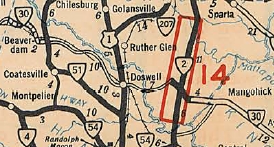
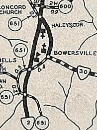
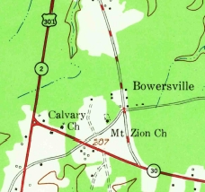
In Jan 1959, a request from Hanover/King William Board of Supervisors to extend VA 30 west to the Doswell Interchange of upcoming I-95 was voted down by the CTB. In 1960 or 1961, VA 30 was removed from its US 360 duplex (now partly SR 662) and also from SR 611 over to Turpin. In Apr 1967 (CTB), VA 30 was approved to be extended west from Dawn to I-95 as a mix of new construction and upgraded SR 652, then replaced VA 79 over to US 1 near Doswell. Official maps show this actually occurring around 1971.
About 1980, VA 30 was extended east from US 60 to its current endpoint at I-64/SR 607, replacing VA 168Y. About 1986, VA 30 was removed from VA 273 and instead followed VA 33 further west, then replaced part of VA 249 southeast back to Barhamsville.
Improvements: The first piece of VA 30 to be paved was from Glenns to Saluda in 1929. In 1932, VA 30 was paved from Central Garage to Urbanna. In 1933, VA 30 was paved on its reroute from West Point to US 60. In 1934, VA 30 was paved on its separate western piece. In 1936, VA 30 was paved from Dawn to Mangohick. In 1938, VA 30 was paved from Mangohick to Central Garage, making VA 30 fully paved. The first piece of VA 30 to be multilaned was in 1964 from today's northern end of VA 273 to the Pamunkey River.. In 1980, VA 30 was multilaned with its extension to I-64/SR 607. In 1986, VA 30 was multilaned when added to VA 33 between VA 249 and VA 273. In 2008, VA 30 was multilaned from I-95 to the Caroline line; across the Pamunkey River. Posted: Fully posted although its SR 607 duplex is posted from I-64 as TO VA 30; Last known cutout was on Main St in West Point, replaced in mid-2000s. Multiplexes: VA 33 (4.90 mi) Legislative names: Washington's Burgess Route, US 301 to US 60 except for VA 273 (since 3-5-40); Pamunkey-Mattaponi Trail, US 360 to West Point (since 1-17-57); Washington-Rochambeau Route, US 60 to VA 249 (since 2-20-75) Eltham Bridge over Pamunkey River, since 3-15-38. Other names: Kings Dominion Blvd (Hanover Co); Dawn Blvd (Caroline Co); King William Rd (King William Co); Main St/14th St (West Point); New Kent Hwy (New Kent Co s of VA 249); Old Stage Hwy (James City Co n of I-64); Barhamsville Rd (I-64 to US 60); Rochambeau Dr (US 60 to SR 607); Croaker Rd (SR 607 duplex) Scenic Byway: no segments Comment: VA 30 is a terrific alternative from the Fredericksburg region to the Williamsburg region. VA 30 serves Kings Dominion and the new State Fairgrounds nearby. | ||||||||||||||||

Previous: VA 29 |
Next: VA 31
Top | Virginia Hwy Index
Home
Page last modified 17 July 2013