|
From:    Gate City (Scott County) Gate City (Scott County)
To:
 Lebanon (Russell County) Lebanon (Russell County)
Total Length: 35.82 miles
|
|
|
|
|
ROUTE LOG
US 23 Bus, US 58 Bus, US 421 Bus: 0 - 0
VA 72: 1.40 - 1.40
Russell-Scott Line: 16.02 - 17.42
US 58 ALT WB: 8.19 - 25.61
US 58 ALT EB: 1.46 - 27.07
US 19 Bus: 8.75 - 35.82
|
|
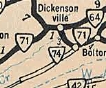
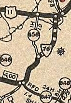
Creation: Appeared in July 1933 as a renumbering of VA 107 from Gate City to Dickensonville and VA 110 from Dickensonville to end at US 19 Hansonville. This is the only VA 71.
VA 71's initial routing from Gate City to Hansonville
1933 Official
Adjustments: In Oct 1940 (CTB), VA 71 was rerouted at Dickensonville to instead head east to US 19 Lebanon. This was a route swap with VA 64.
VA 71 rerouted to Lebanon
1941-42 Official
|
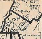
VA 71's ending in Lebanon (1940-60)
1951 Official
|
In Aug 1941 (CTB), VA 71 was rebuilt in the Nickelsville area, leaving behind SRs 633/680.
In 1951, VA 71 was rebuilt east of GAte City leaving behind several SR 79x loops.
In Aug 1960 (CTB), VA 71's eastern end was moved to its current endpoint, leaving behind a bit of VA 82 and Old Fincastle Rd.
Improvements: Paved upon inception except between Snowflake and Nickelsville which didn't get paved until 1948.
Multilaned on its US 58 ALT duplex in 1974
Posted: Fully posted;
Multiplexes: US 58 ALT (1.46 mi)
Legislative names: Trail of the Lonesome Pine, from Dickensonville to Lebanon (3-24-30 designation predates VA 71)
Other names: Jackson St (Gate City); Nickelsville Hwy (Russell Co) Fincastle Rd (Lebanon)
Scenic Byway: US 58 ALT to US 19 Business, since 3-8-93
Comment: VA 71 is a suitable alternative to reach I-81 in Tennessee via US 23 as opposed to US 19.
|
 |
From:  Gate City (Scott County) Gate City (Scott County)
To:
 Georges Fork (Dickenson County) Georges Fork (Dickenson County)
Total Length: 49.19 miles
|
|
|
|
|
ROUTE LOG
VA 71: 0 - 0
VA 65 WB: 10.78 - 10.78
VA 65 EB: 8.39 - 19.17
Wise-Scott Line: 5.77 - 24.94
US 58 ALT: 5.65 - 30.59
VA 158 EB: 0.19 - 30.78
VA 158 WB: 0.65 - 31.43
Dickenson-Wise Line: 10.08 - 41.51
VA 83: 7.68 - 49.19
|
|
Creation: Appeared in July 1933 as a renumbering of VA 122, running from VA 71 Nickelsville to VA 59 (now SR 766) Georges Fork. This is the only VA 72.
Adjustments: In April 1949 (CTB), VA 72 south was truncated to Dungannon (at the curve below SR 1007), leaving behind its VA 65 duplex and SR 774 to Nickelsville. Initially, VA 65-72 cut south at the curve south of SR 1007, then crossed the RR onto Emmet St which curls around to Washington St which used to cross the Clinch River, then VA 65-72 used SR 659 east to current VA 65.
In May 1956, the CTB turned down a request by the Scott County BOard of Supervisors to re-extend VA 72 to Nickelsville.
In June 1966 (CTB), THe McClure River Development Club requested to the CTB that VA 72 be extended north to the John Flanagan Dam. There are several ways this could've been done, but VA 63 ran within 2 miles of the dam as it was...
In Oct 1972, the CTB turned down a request from the Dickenson County Board of Supervisors to add SR 607/614 from Clintwood to VA 63 near Haysi to the primary system, which would almost certainly have been an extended VA 72.
In Nov 1973 (CTB), VA 72 was extended north as new construction to the relocated VA 83.
In March 1979 (CTB), VA 72 in Dungannon was truncated to the current VA 65 split over the Clinch River, replaced by a relocated VA 65.
In May 1986 (CTB), VA 72 was extended west along VA 65 to Fort Blackmore, then south to SR 627 over parts of SRs 619, 676, 661, 710 and 660. VA 72 was formally assigned to the gap to VA 71 then as well.
In Aug 1999 (CTB), VA 72 was removed from Quillen Ave in Coeburn to accomodate the US 58 ALT interchange.
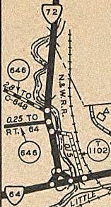
In Feb and June 2001 (CTB), VA 72 was totally rebuilt south of VA 65, plus completed to VA 71, leaving behind a bunch of abandoned alignments plus SR 967 and some of SR 659.
|
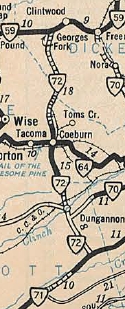
VA 72 initial routing
1933 Official
|
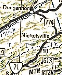
VA 72 truncated to Dungannon
1950 Official
|
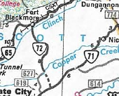
VA 72 re-extended south
1988 Official
|

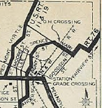
VA 72 connects to VA 71
2002-04 Official
|
Improvements: Paved upon inception only from Scott-Wise line to a couple miles north of Coeburn
By 1936, VA 72 was paved from Coeburn to Georges Fork
In 1948, VA 72 was paved from Dungannon to Nickelsville
VA 72 was finally paved from Dungannon to Wise County in 1953.
Posted: Fully Posted
Multiplexes: VA 65 (8.39 mi)
VA 158 (0.65 mi)
Legislative names: Veterans Memorial Highway, from VA 71 to VA 65 (since 6-17-99); Guy D. Culbertson Memorial Bridge over Copper Cr, Scott Co (since 11-19-92); Harold L Lingley Bridge over Little Toms Creek/CSX RR, Coeburn (since 4-8-98); Veterans Memorial Bridge over Clinch River (since 1-18-01)
Other names: Hanging Rock Pkwy (VA 65 to Wise); Dungannon Rd (US 58 ALT s to Scott); Front St/Laurel Ave (Coeburn); Cranes Nest Rd (Coeburn to Dickenson); Coeburn Rd (Dickenson Co)
Scenic Byway: VA 65 duplex since about 2007
Comment: VA 72 has many serious curvature issues in several places along its routing. Very slow as a through route.
The 1939 VDOT report on primary system development had recommended that VA 72 be decommissioned from Dungannon to Coeburn.
|
| Previous VA 72's:
|
|
VA 72-Y?: Appeared by 1936 but may have been a July 1933 renumbering of VA 122-Y on the western leg of a triangle formed by VA 72 and VA 64 (now VA 158) in Coeburn. VA 64 from the west was using SR 813.
This triangle is still present on the 1958 Wise County map, so my guess is that this went away when US 58 ALT was moved to the current VA 158 west of here in 1971.
|
VA 72Y?
1936 Wise County
|
|
 |
From:
 Henrico County Henrico County
To:
 EXIT 82 Henrico County EXIT 82 Henrico County
Total Length: 0.78 miles
|
|
|
|
|
ROUTE LOG
US 1: 0 - 0
I-95 (exit 82): 0.78 - 0.78
|
|
Creation: Created Aug 1958 (CTB) as an upgrade to Dover St in Henrico County between US 1 and the under-construction I-95. This is the 2nd VA 73.
Adjustments: None
Improvements: fully paved and likely multilaned by the time 95 was finished in the area
Posting: Fully posted; On 7/13/03 I spotted a white interstate 73 shield on temporary BGS on I-95 SB.
Multiplexes: None
Legislative names: None
Other names: Parham Rd
Scenic Byway: No segments
Comments: VA 73 does not appear explicitly on official maps until 1966.
Many commercial maps incorrectly show VA 73 all over Parham Rd
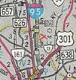
Current VA 73
1966 Official
|
VA 73 with a trumpet interchange at I-95
1975 Henrico County
|
|
| Previous VA 73's:
1947 ROUTE LOG
US 23, VA 64: 0 - 0
Scott-Wise Line: 5.30 - 5.30
|
|
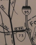
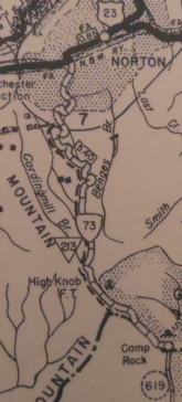
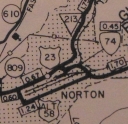
VA 73 #1: Appeared in July 1933 as a renumbering of VA 141, running from US 23/VA 64 (now just Main Ave SW) south on 12th out of NOrton and ending just short of the Scott County line at High Knob.
In Sept 1937 (CTB), VA 73 was extended south 0.38 miles to the county line.
In May 1948 (CTB), VA 73 was downgraded to SR 619.
I wonder if this had been anticipated to run south to Fort Blackmore or maybe even Gate City...
VA 73 #1
1936 Wise County
|
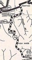
VA 73 extended to Scott County
1946 Wise County
|
|
 |
From:
City of Norton
To:  Ramsey (Wise County) Ramsey (Wise County)
Total Length: 2.42 miles
|
|
|
|
|
ROUTE LOG
US 23 Bus: 0 - 0
Wise-Norton Line: 2.16 - 2.16
US 58 ALT: 0.26 - 2.42
|
|
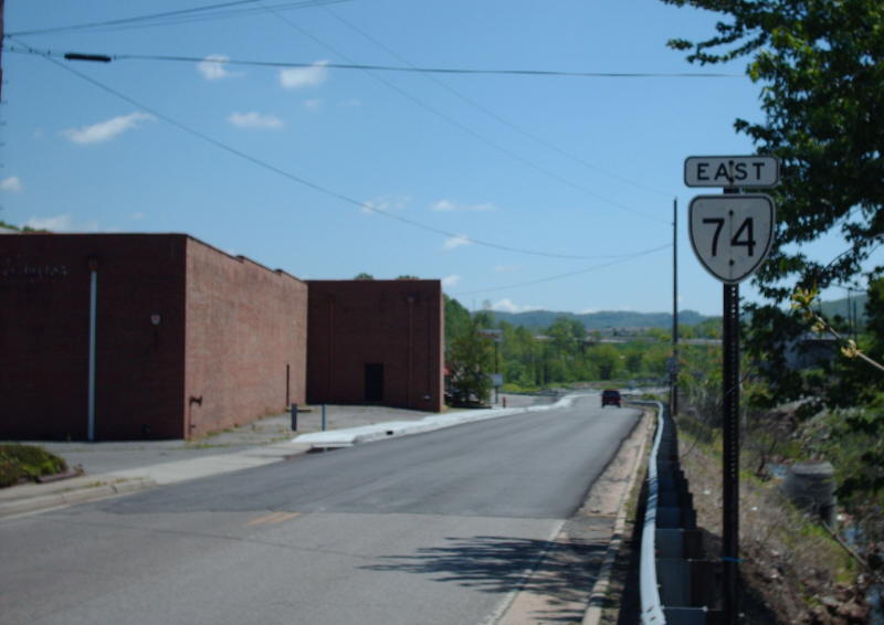
Creation: Appeared May 1958 (CTB) as a renumbering of US 58 ALT, running the 0.45 miles from US 23 Park Ave to US 58 ALT Kentucky Ave. This is the 2nd VA 74.
Adjustments: In June 1988 (CTB), VA 74 was extended east to its current endpoint, replacing more of US 58 ALT.
Improvements: Paved upon inception; no multilane segments.
Posting: Fully posted; cutouts remained as of 2009
Multiplexes: None
Legislative names: None
Other names: Coeburn Rd/Kentucky Ave
Scenic Byway: no segments
Comment: VA 74 is blown off by the US 23-58 ALT freeway.
The first official map to show VA 74 was the 1977 issue. Then VA 74 disappeared from maps 1986-89 before retuening for good in 1990.
| 
VA 74 initial routing
1975 Wise County
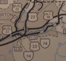
VA 74 extended east
1995 Wise County
|
| Previous VA 74's:
1947 ROUTE LOG
VA 71: 0 - 0
SR 613: 6.36 - 6.36
|
|
VA 74 #1: Appeared in July 1933 as a renumbering of VA 134, running from VA 71 (now US 58 ALT) Bolton southwest to just past SR 606 near Willow Spring.
In Sept 1942 (CTB), VA 74 was downgraded to SR 613.
| 
VA 74 #1
1933 Official
|
 |
From:
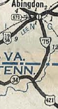
Valley Ave (2 blocks north of  Abingdon (Washington County) Abingdon (Washington County)
To: Tenneessee State Line near Painter Spring (Washington County)
The route continues as TN 44 to Bluff City, TN
Total Length: 10.61 miles
|
|
|
|
|
ROUTE LOG
Valley Ave: 0 - 0
US 11, US 58 ALT WB: 0.10 - 0.10
I-81 (exit 17), US 58, US 58 ALT End: 0.78 - 0.88
TN STATE LINE: 9.73 - 10.61
|
|
Creation: Appeared Oct 1940 (CTB) as a renumbering of VA 77, running from US 11 Abingdon south to Tennessee. This is the 2nd VA 75.
Adjustments: In April 1964 (CTB), VA 75 was removed from Pecan St/Green Spring Rd south of Main St and placed instead on Cumming St up to US 11 Main St.
In May 1965 (CTB), VA 75 was extended north from Main St to end at Valley Ave. The reason given was that it was anticipated that US 11-58 would be moved to VAlley Ave in the future. They're still waiting for that.
In March 1974 (CTB), VA 75 was removed from SR 903 and the SR 677/902 loop a little south of I-81.
In April 1987 (CTB), VA 75 was rebuilt through the Green Springs area on mostly new construction, leaving behind SR 911, a bit of SR 655, SR 670 Green Springs Church Rd and SR 658 Lombardy Ln.
Improvements: Paved upon inception; Multilane from I-81 to US 11 back to at least 1988.
Posting: Fully posted, even at Valley Ave at last field check; cutouts removed from Abingdon in early 2000s.
Multiplexes: US 58 ALT (0.78 mi)
Legislative names: None
Other names: Cumming St (Abingdon); Green Spring Rd (Washington Co)
Scenic Byway: no segments
Comment: The Oct 1940 CTB was expecting Tennessee to number their side as TN 75 but for some reason they did not. Of course this "problem" can be fixed - VA 44 is available for action!
The VDOT interactive map shows VA 75 ending at US 11. This may be a change but I have not seen any CTB documentation for it. Another field visit is in order.
VA 75 parallels the South Holston River Lake area and can also be used in conjunction with US 421 as a back way to get to southern Bristol destinations.
The 1939 VDOT report on primary system development had recommended that VA 75 (then VA 77) be decommissioned in its entirety.
| 
Current VA 75
1941-42 Official
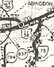
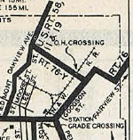
VA 75 ending further east on US 11-58
1958 Washington County
|
| Previous VA 75's:
1940 ROUTE LOG
US 58, US 421: 0 - 0
SR 700: 5.15 - 5.15
|
|
VA 75 #1: Appeared in July 1933 as a renumbering of VA 140, running from US 58 northeast to just past SR 640 near Benhams.
In Oct 1940 (CTB), VA 75 was renumbered as VA 77. Today it is part of SR 700.
| 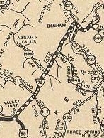
VA 75 #1
1936 Washington County
|
 |
From:  City of Richmond City of Richmond
To:
 Midlothian (Chesterfield County) Midlothian (Chesterfield County)
Total Length: 13.04 miles
|
|
|
|
|
ROUTE LOG
I-195: 0 - 0
VA 146: 0.94 - 0.94
VA 150: 2.50 - 3.44
Chesterfield-Richmond Line: 0 - 3.44
US 60: 3.24 - 6.68
VA 288: 5.07 - 11.75
SR 652: 1.29 - 13.04
|
|
Creation: First mentioned in the July 1972 CTB but officially placed in the primary system in April 1973 (CTB) as the designation for the Powhite Pkwy under construction from I-195 to VA 150, and also to the proposed extension 10 more miles out to Chesterfield County beyond VA 288. The 1973 Official shows the Powhite Pkwy as open from VA 150 to VA 147. This is the 2nd VA 76.
Adjustments: In 1989, VA 76 was opened from VA 150 out to its current end, which is a half mile or so west of the SR 754 stoplight after VA 288.
Improvements: Full freeway upon opening of segments.
Posting: Fully posted; The western endpoint which is not at any intersection is clearly marked.
Multiplexes: None
Legislative names: None
Other names: Powhite Pkwy, Old hundred Rd
Scenic Byway: No segments
Comment: VA 76 is a toll road from VA 288 to I-195.
There are ruminations regarding extending VA 76 out to US 360 in the Skinquarter area.
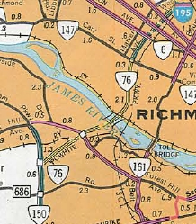
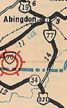
Current VA 76 appears
1974 Official
|
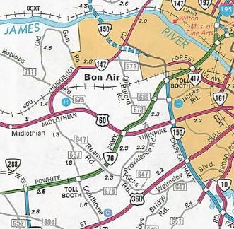
VA 76 extended to Old Hundred Rd
1989 Official
|
|
| Previous VA 76's:
1970 ROUTE LOG
US 11, US 19: 0 - 0
Bristol-Washington Line: 3 - 3
|
|
VA 76 #1: Appeared in July 1933 as a renumbering of VA 109 running from US 11-19-58 (now VA 113) Bristol east on Mary St, north on Goodson St, east on Danville Ave, north on Fairview St, east on Massachussetts Ave and then used King Mill Pike, then Old Airport Rd northeast to about the current jct with Bonham Rd.
In Sept 1934 (CTB), VA 76 was extended northeast on old Airport Rd back to US 11-19-58 just past I-81 exit 7.
In 1934, VA 76 was rerouted to leave Mary St at Spencer St, then south on Front St (essentially Martin Luther King Jr Blvd) to end at US 11E-19-321 State St. The rest of Mary St west to Piedmont was unnumbered though later became VA 76-Y.
CTB minutes lack info and maps are a little ambiguous but it appears in 1937 VA 76 was changed to follow Goodson St to State St. Maps from 1937-41 show all 3 VA 76 Bristol routings as primary, hence the confusion.
The 1934 rerouting may have placed VA 76 on State St west to US 19 Anderson St but it definitely was that way by 1946.
VA 76 using Mary St
1933 Official
|
VA 76 using Spencer/Front Sts
1934 Official
|
VA 76 using Goodson
1941-42 Official
|
VA 76 along State St
1946 Washington County
|
In June 1947 (CTB), VA 76's northern end was moved to instead replace SR 658 Bonham Rd up to US 11-19-58. Old Airport Rd northeast to US 11-19-58 became SR 658 instead.
VA 76 ends near SR 659
1936 Washington County
|
VA 76 swaps with SR 658
1958 Washington County
|
In May 1952 (CTB), VA 76 was changed in Bristol: SB was extended west along State St to end at 4th St (essentially MLK Jr Blvd); NB was changed to start at Lee and Cumberland, running east along Cumberland to Front (MLK Jr Blvd), then south to State then east to Goodson and then north on Goodson. Thus, technically, some of VA 76 NB ran in Tennessee...
In Dec 1966 (CTB), VA 76 was decommissioned within the city limits of Bristol which then was along Kings Mill Road, 0.38 miles east of Hillside Ave.
In April 1970 (CTB), the Washington County portion of VA 76 was downgraded to SR 895 (now all unnumbered as Bristol has annexed this area).
VA 76 was blown off by I-81.
VA 76 along State St
1961 Washington County
|
VA 76 south truncated to Bristol CL
1969 Washington County
|
VA 76-Y: Looks to have been born in July 1933 as a renumbering of VA 109Y although it was shown unlabeled starting on the 1937 official and explicitly shown on maps starting in 1941. Ran from VA 76 State St north on Front St then est on Mary St to end at VA 76 Goodson St.
It appears that in 1934, VA 76Y was changed to run from US 11-19-58 (now VA 113) east along Mary St to VA 76 Goodson St. Maps of Bristol in the early days did not seem to show primary routings specifically defined in the CTB Minutes.
In Dec 1966 (CTB), VA 76-Y was renumbered as part of US 421. Today Mary St. is unnumbered.
|
|
VA
77 not currently assigned |
|
|
|
|
Previous VA 77's:
1940 ROUTE LOG
US 11, US 58: 0 - 0
TN STATE LINE: 14 - 14
1940 ROUTE LOG
US 58, US 421: 0 - 0
SR 700: 5.15 - 5.15
|
|
VA 77 #1: Appeared July 1933 as a renumbering of VA 110 from US 11-58 Abingdon south to just short of the Tennessee Line.
In Aug 1933 (CTB), VA 77 was extended south 0.14 miles to Tennessee.
In Oct 1940 (CTB), VA 77 was renumbered as VA 75. Today it is Pecan St/Green Springs Rd south of US 11, then VA 75 to Tennessee except: SR 903 and the SR 677/902 loop a little south of I-81; In the Green Springs area - SR 911, a bit of SR 655, SR 670 Green Springs Church Rd and SR 658 Lombardy Ln.
VA 77 #2: Appeared Oct 1940 (CTB) as a renumbering of VA 75. Ran from US 58-421 northeast to just past SR 640 near Benhams.
In Sept 1942 (CTB), VA 77 was downgraded to SR 700.
VA 77 #1
1933 Official
|
VA 77 #2
1941-42 Official
|
|
 |
From: Appalachia (Wise County)
To:
 Stonega (Wise County) Stonega (Wise County)
Total Length: 3.85 miles
|
|
|
|
|
ROUTE LOG
US 23 Bus: 0 - 0
SR 600: 3.85 - 3.85
|
|
Creation: Appeared in May 1946 (CTB) as a renumbering of VA 62 running the way it does now except its south end was on Main St underneath the current US 23 Bus viaduct in Appalachia. This is the 3rd VA 78.
Adjustments: In March 1989 (CTB), VA 78 was extended south around to US 23 Business as it does now, replacing what had been US 23.
Improvements: paved upon inception; no multilane segments.
Posting: Fully posted;
Multiplexes: None
Legislative names: None
Other names: Stonega Rd
Scenic Byway: No segments
Comment: Because VA 78 curls underneath US 23 Business, it looks like its directional postings are wrong at US 23 Business.
|
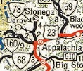
Current VA 78
1947 Official
|
|
| Previous VA 78's:
1940 ROUTE LOG
US 58: 0 - 0
TN STATE LINE: 2.25 - 2.25
1943 ROUTE LOG
VA 61: 0 - 0
SR 623: 8.00 - 8.00
|
|
VA 78 #1: Appeared in July 1933 as a renumbering of VA 130 running from US 58 (now US 58/VA 91 split in central Damascus) south along today's US 58/VA 91, then SR 1212 Orchard Park Rd, then VA 91 south to Tennessee.
In Oct 1940 (CTB), VA 78 was renumbered as part of VA 91.
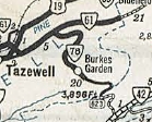
VA 78 #2: Appeared in Oct 1940 (CTB) as a renumbering of VA 87 running from VA 61 to SR 623 Burkes Garden.
In April 1944 (CTB), VA 78 was downgraded to SR 623.
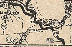
VA 78 #1
1936 Washington County
|
VA 78 #2
1941-42 Official
|
|
 |
From:  Linden (Warren County) Linden (Warren County)
To:
 Linden (Warren County) Linden (Warren County)
Total Length: 0.23 miles
|
|
|
|
|
ROUTE LOG
VA 55: 0 - 0
I-66 (exit 13): 0.23 - 0.23
|
|
Creation: Appeared about 1980 running the way it does now. This is the 3rd VA 79.
Adjustments: None
Improvements: Paved upon inception; no multilane segments
Posting: fully posted;
Multiplexes: None
Legislative names: None
Other names: Apple Mountain Rd
Scenic Byway: no segments
Comment: VA 79 is one of the shortest state routes in Virginia...should probably have been numbered VA 55Y.
| 
Current VA 79
1982-83 Official
|
| Previous VA 79's:
1952 ROUTE LOG
VA 79: 0 - 0
US 11: 6 - 6
1970 ROUTE LOG
US 1: 0 - 0
I-95: 1 - 1
|
|
VA 79 #1: Appeared in July 1933 as a renumbering of VA 135 running from US 58 (now SR 660) St Clair Bottom northwest to US 11 (now T-1004 Main St) Chilhowie.
In May 1945 (CTB), VA 79 was extended southwest to VA 91 Lodi, replacing part of VA 81.
In March 1946 (CTB), VA 79 was extended northwest from Main St to the rerouted (current) US 11.
In May 1953 (CTB), VA 79 was downgraded to SR 762.
Today it is the last bit of VA 107, SR 1034, SR 762, and SR 600.
VA 79 #2: Appeared in April 1960 (CTB) as a connector between US 1 and I-95 at Doswell, which didn't open until around 1965.
Around 1971, VA 79 was renumbered as part of VA 30.
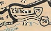
VA 79 #1
1933 Official
|
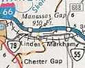
VA 79 extended to Lodi
1946 Official
|
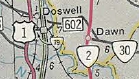
VA 79 #2
1966 Official
|
|
  |
From: Meadowview (Washington County)
To:
Kentucky State Line at Breaks Interstate Park (Dickenson County)
Total Length: 67.35 miles
The route conitnues as KY 80 all the way to essentially the Mississippi River.
|
|
|
|
|
ROUTE LOG
US 11: 0 - 0
I-81 (exit 24): 0.75 - 0.75
Russell-Washington Line: 14.21 - 14.96
US 19 SB: 6.23 - 21.19
US 19 NB: 2.57 - 23.76
VA 67: 4.50 - 28.26
Buchanan-Russell Line: 6.84 - 35.10
Dickenson-Buchanan Line: 9.92 - 45.02
VA 83 WB: 10.81 - 55.83
VA 63: 0.34 - 56.17
VA 83 EB: 1.09 - 57.26
Buchanan-Dickenson Line: 8.49 - 65.75
KY STATE LINE: 1.60 - 67.35
|
|
|
Creation: Appeared July 1933 as a renumbering of VA 111 as the only VA 80. It initally was not a complete route but instead ran:
1. US 58 (now SR 924) Lodi northwest to 5 miles north of US 11 near Meadowview
2. roughly Washington SR 611 EB north through Rosedale and Honaker to a little past Council
3. Buchanan-Dickenson line north through Haysi to 8 miles north of VA 83 EB
Adjustments: In Aug 1933 (CTB), VA 80 was extended 0.80 miles from SR 611 EB south to SR 611 WB
In Sept 1934 (CTB), VA 80 piece 1 was extended north to meet piece 2.
In May 1938 (CTB), VA 80 piece 3 was extended north to the Buchanan County line near Breaks Interstate Park.
In April 1944 (CTB), piece 2 was connected to piece 3 northwest of Council, replacing SR 602.
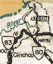
In May 1945 (CTB), VA 80 north was truncated to VA 83 (current VA 63) Haysi, leaving behind its VA 83 duplex and SR 610.
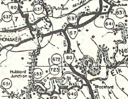
In 1947 (CTB), VA 80 was rebuilt between US 19 and Honaker on mostly new location but also replaced a bit of VA 67. Today the old routing is SR 672 and Clover Rd but is mostly not a road today.
|
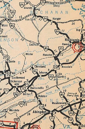
VA 80 in 3 pieces
1933 Official
|

VA 80 north to Honaker
1935 Russell County
|
VA 80 shifted east
1958 Russell County
|
In May 1948 (CTB), VA 80 south was truncated to US 11, leaving behind SR 803.
In May 1950 (CTB), VA 80 was re-extended north from Haysi over SRs 610 and 612 to the Kentucky State Line, because Kentucky was building KY 80 and asked Virginia to meet them with a primary route.
VA 80 truncated to Haysi
1946 Official
|
VA 80 recalled to Kentucky
1951 Official
|
In July 1969 (CTB), VA 80 was removed from SR 772 at the N. Holston River.
In June 1974 (CTB), VA 80 was removed from the SR 768 loop through Breaks.
Sometime after 1958 VA 80 was removed from SR 1030 in Council.
In July 1969 (CTB), VA 80 was removed from SR 772 at the N. Holston River.
In June 1974 (CTB), VA 80 was removed from the SR 768 loop through Breaks.
Sometime after 1958 VA 80 was removed from SR 1030 in Council.
Improvements: Upon designation, section 1 was all-paved; section 2 was paved from Elk Garden to Council; section 3 was only paved on the VA 59 (now 83) duplex.
The 1934 extension north of piece 1 was paved.
In 1940, VA 80 was paved from Davenport west to Dickenson line
in 1941, VA 80 was paved from Council to Davenport and also from Haysi south to SR 602.
In 1948, VA 80 was paved from Elk Garden south to the 1934 extension point.
In 1950, VA 80 was paved from SR 602 to Buchanan line, completing the paving of VA 80.
VA 80 is multilnae only on its US 19 duplex which happened in 1978.
Posting: fully posted;
Multiplexes: US 19 (2.57 mi)
VA 83 (1.43 mi)
Legislative names: Cumberland Scenic Trail, Haysi to the Kentucky Line (since 3-31-64); Helen Henderson Highway, Rosedale to the Kentucky Line (since 3-23-50)
Other names: Glennbrook Ave (Meadowview); Lindell Rd (I-81 to SR 740); Hayters Gap Rd (SR 740 to US 19); Honaker Rd (US 19 to Honaker); Red Bud Hwy (Honaker to Dickenson line); Dickenson Hwy (Haysi); Breaks Park Rd (VA 83 to KY)
Scenic Byway: none
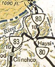
Comment: VA 80 serves Breaks Interstate Park which has some impressive canyons formed by the Big Sandy River.
VA 80 between I-81 and US 19 is one of the least improved highways in the state. Many sharp bends and blind curves, though not quite as bad (but narrower) as VA 16. The pavement narrows around Hayters Gap to where it is not striped. This is not a suitable route for trucks who must use US 19 out of Abingdon or I-77 and US 19 from Bluefield to get to Honaker from the I-81 corridor.
VA 80 is signed E-W although it is much more of a N-S route.
The 1939 VDOT report on primary system development had recommended that VA 80 be decommissioned from Honaker to Haysi and also from US 19 south to SR 689 (potentially a piece of VA 42).
|
|
Previous: VA 61 - 70 |
Next: VA 81 - 100
Top | Virginia Hwy Index
Home
Page last modified
7 July 2017
|