VA 313
< VA 312 | Home | VA 314 >
VA 313
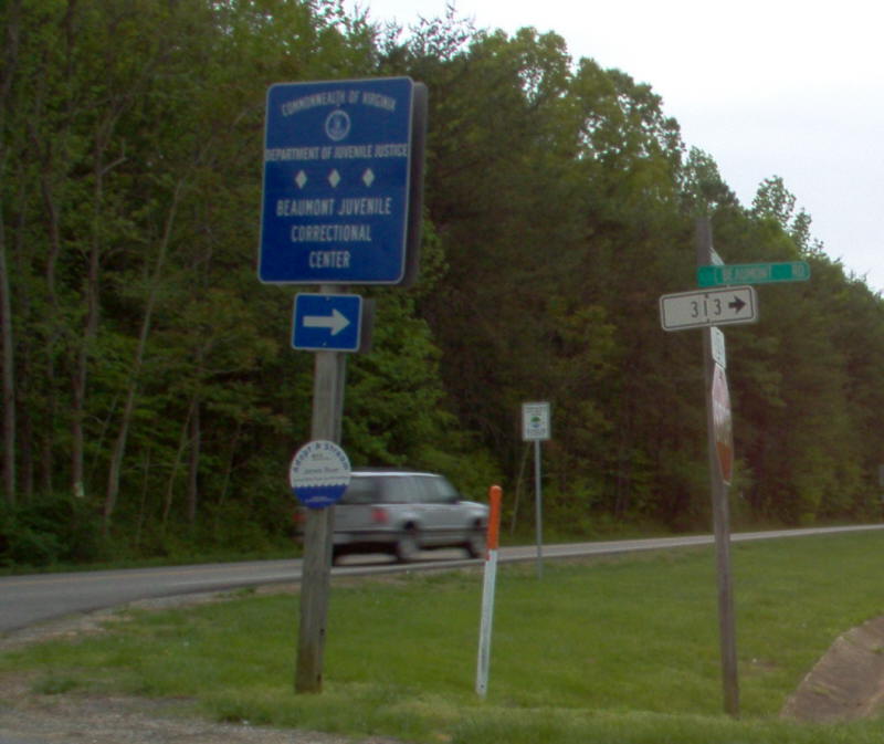
Photo: VA 313 from US 522 southbound (photo by Mapmikey, April 2006)
From:  Maidens (Powhatan County)
To:  Beaumont Learning Facility (Powhatan County)
Total Length:  2.08 miles  


Creation:  Unknown - although there has been room on many official maps to show this, it never has. The July 1932 CTB Minutes assign 1.96 miles to the Industrial School for Boys in Maidens, VA. Some of the buildings at the facility look pretty old. Based on the number I presume this was designated in the 1938 timeframe, This is the 3rd VA 313.
Adjustments:  In March 1973 (CTB), VA 313 was extended east from original US 522 (SR 669) to the new US 522
Posting:  White rectangles at US 522 and SR 669.
Other Names: Beaumont Rd
Comment:  Newer roads at the facility have "end state maintenance" signs at them, so VA 313 is some of the interior roads but not all of them. The access road itself is narrow and substandard, although in 2006 it was resurfaced and perhaps widened a little.
Beaumont officially closed in June 2017. There remains a small detention center run by a different state entity. However, much of the Beaumont property is being studied for future use, including the potential to become the main entrance to the fairly new Powhatan State Park which is adjacent to the property and whose entrance off SR 617 is not ideal.

Current VA 313
1946 Powhatan County
Previous VA 313's:

1928 ROUTE LOG
BEGIN VA 313: 0 - 0
US 1, VA 31: 5.5 - 5.5


1932 ROUTE LOG
US 60, VA 13: 0 - 0
Amherst-Nelson Line: 7.4 - 7.4
VA 18: 4.1 - 11.5
VA 18: 20 - 31.5

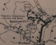
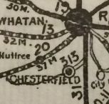
VA 313 #1:  Appeared March 1924 (CTB Minutes) as a new routing. Ran from VA 31 (curr SR 1625) near Centralia to Chesterfield.
VA 313 was renumbered as VA 410 in August 1928. Today it is VA 145.


VA 313 over to Chesterfield
1924 Official
VA 410 (1932 Official)
VA 410 replaces VA 313
1932 Official

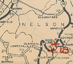
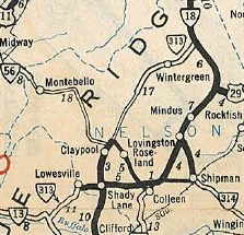
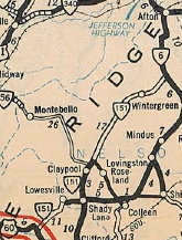
VA 313 #2:  Appeared in August 1928 as a renumbering and expansion of original VA 182. Ran from VA 18 (current VA 151) Shady Lane towards Lowesville, then to VA 13 (curr SR 610-617 jct) east of Sandidges.
In Dec 1930 (CTB), VA 313's south end was rerouted to meet the new VA 13 (curr US 60) south of Henley's Store, leaving behind CR 118 (now SR 610).
In 1932, VA 313 was extended over what had been part of VA 18 to Claypool. VA 313 was also assigned to what had been VA 315 which ran from VA 18 Greenfield (curr VA 6) southwest to Brent Gap.
In July 1932 (CTB Minutes), the new piece of VA 313 was extended 7.68 more miles south, to where VA 313 from the south at Claypool was waiting.
VA 313 was renumbered as part of VA 151 in July 1933. Today it is SR 778 (except VA 313 used SR 665 and SR 694) and VA 151 (except VA 313 used parts of SRs 612, 613, and 627 in the Wintergreen-Nellysford areas).


VA 313 in the Lowesville area
1929 Official

VA 313 extended north over VA 315
Also note it now meets VA 13 east of the sharp turn in VA 13
1932 Official
VA 151 (1933 Official)
VA 151 replaces VA 313
1933 Official


Previous: VA 312  |  Next: VA 314
Top  |  Virginia Hwy Index Home

Page last modified 4 April 2020