|
From:
 South Norfolk (City of Norfolk) South Norfolk (City of Norfolk)
To:
Virginia Beach-Chesapeake Line
Total Length: 2.32 miles
|
|
|
|
|
|
ROUTE LOG
VA 168: 0 - 0
Chesapeake-Norfolk Line: 0.71 - 0.71
Virginia Beach-Chesapeake Line: 1.61 - 2.32
|
|
Creation: VA 407 was created in Dec 1980 (CTB) as new
primary routing, running from VA 168 Campostella Rd east to the
Chesapeake Line. This is the 3rd VA 407.
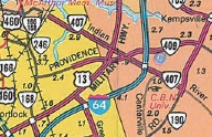
Adjustments: In March 1981, a disconnected piece of VA 407 was put on Indian River Rd from US 13 east to VA 190 Kempsville.
In April 1981 (CTB), the original piece of VA 407 was extended east through Chesapeake to the Virginia Beach Line.
In July 1981 (CTB), VA 407 was put on Indian River Rd from US 13 west to the Chesapeake Line, connecting the two pieces.
In January 2001 (CTB), VA 407 was decommissioned in Virginia Beach,
truncating the eastern end to the Chesapeake-Virginia Beach Line.
Improvements: paved upon inception.
The Chesapeake and Virginia Beach segments were 4-laned upon inception.
The Norfolk part of VA 407 was 4-laned in 1999 or 2000.
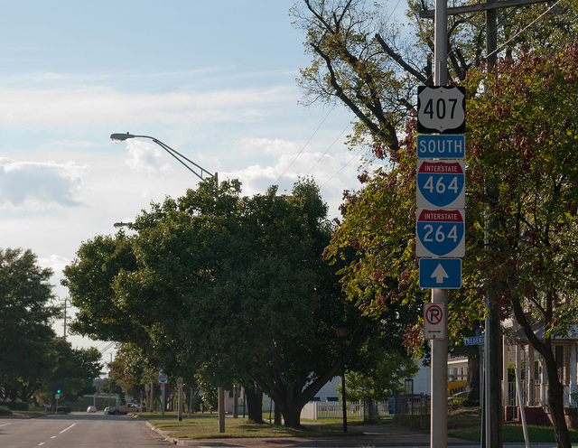
Posted: VA 407 is still fairly well posted in Norfolk
and Chesapeake (verified 2023), and was even signed west of VA
168, suggesting that it might have gone as far as VA 337. There is even
an error US 407 shield westbound on the Berkley Ave Extension that has been there at least 15 years (near I-464). Another error US 407 shield near Marsh St was
removed by 2013.
Multiplexes: None
Legislative names: None
Other names: Indian River Rd
Scenic Byway: No segments
Comment: VA 407 is shown as fully decommissioned in
the 2003 Route log and was removed from state officials, but it is shown as an active primary route on the
2008 Traffic Logs and also on the VDOT on-line interactive map.
|
1986 Official |
|
Previous VA 407's:
1932 ROUTE LOG
US 60, VA 20: 0 - 0
VA 410: 11.15 - 11.15
VA 425: 5.35 - 15.50
US 1, VA 31: 1.70 - 17.20
VA 408: 8.24 - 25.44
VA 435: 4.30 - 29.74
VA 10: 6.00 - 35.74
|
|
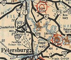
VA 407 #1: Appeared in August 1928 as a replacement for the westernmost half mile of VA 313 at Chesterfield CH, then new primary routing from today's VA 145 east through Chester to US 1/VA 31 Dutch Gap, then replaced VA 316 east to Hopewell, then as more new primary routing southeast to end at VA 10 (now SR 609) Garysburg.
VA 313 Chesterfield to Centralia
1924 Official |
VA 407 extended to Richmond
1932 Official |
In Dec 1930 (CTB), a second VA 407 piece was created running from US 60/VA 20 (now US 360) Richmond south 6.5 miles.
In July 1932 (CTB), the two pieces were connected as an upgrade to CR 14A.
In July 1933, VA 407 was renumbered as VA 37.
Today it is VA 10 except at Chesterfield VA 407 used SR 655 to cut the
corner and in Chester it used SR 681 approaching Chester. In Hopewell,
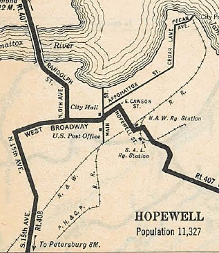
VA 407 used today's VA 10 to VA 36 south, then east on Broadway/E
Cawson St, then southeast on Hopwell St to Terminal St southeast back
to current VA 10.
VA 407 extended to Richmond
1932 Official |
VA 407 Hopewell Routing
1932 Official |
VA 37 Chesterfield to Garysville
1933 Official |
|
VA 407 #2: Appears in CTB Minutes March 1957 and May 1958
referring to a road project from NCL of Bristol to State St. in
Bristol. This became I-381 and VA 381.
|