< SC 29 | Home | SC 30 ALT | SC 31 >
|
|
|
| ROUTE LOG |
SC 171: 0 - 0 SC 61: 2.2 - 2.2 US 17: 0.8 - 3.0
|
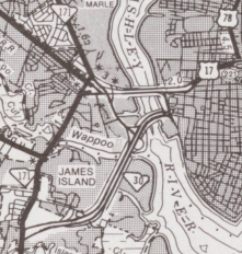
Creation: Appeared as new freeway construction about 1995. Initially ran only from SC 171 to Calhoun St/Lockwood Drive in Charleston. This is the 3rd SC 30.
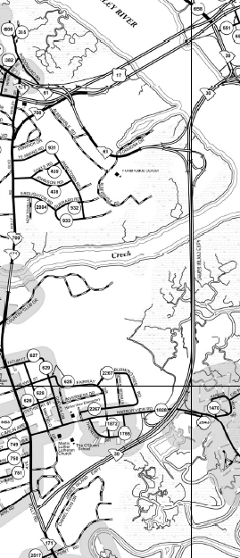
| Adjustments: In 1997, SC 30 was extended north to US 17.
Improvements: SC 30 was paved upon designation. SC 30 was multilaned in all segments upon designation; SC 30 is a full freeway except for Calhoun St to US 17. Comment: SC 30 provides an alternative routing to get from SC 171 and James Island to Downtown Charleston, utilizing a new Ashley River crossing that mars that side of the peninsula's view. The freeway between Harbor View Drive and Calhoun St was opened as unnumbered freeway for a time prior to receiving the SC 30 designation. SC 30 is actually the original planned end of I-526, if the 2 Stono River Bridges ever get built. As of this writing the plan had been scaled down to a non-interstate connection although the project was rejected in 2015 government action. | Previous SC 30's:
1932 ROUTE LOG US 17: 0 - 0 SC 64 EB: 0.5 - 0.5 SC 64 WB: 0.5 - 1 SC 65: 11 - 12 US 78: 10 - 22 SC 2, SC 24: 6 - 28 SC 31: 10 - 38 SC 4 WB: 7 - 45 SC 45: 1 - 46 SC 4 EB: 11 - 57 SC 26 SB: 21 - 78 US 76, SC 26 NB: 2 - 80 SC 302: 11 - 91 SC 44: 5 - 96 SC 34 WB: 6 - 102 SC 341 SB: 1 - 103 SC 341 NB: 1 - 104 SC 34 EB, SC 301: 6 - 110 SC 35: 6 - 116 US 601 SB: 15 - 131 US 601 NB: 2 - 133 SC 381: 8 - 141 SC 9 WB, SC 38 SB: 5 - 146 SC 9 EB, SC 38 SB: 1 - 147 SC 381: 10 - 157 NC STATE LINE: 1 - 158 1955 ROUTE LOG US 221: 0 - 0 SC 308: 4.9 - 4.9 Spartanburg-Laurens Line: 3.5 - 8.4 SC 92: 1.9 - 10.3 |
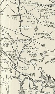
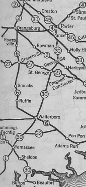
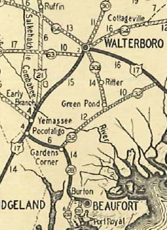
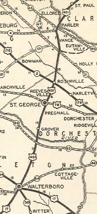
SC 30 #1: An original state route. Ran from SC 27 (current US 78) St George south through Walterboro and Yemasee before heading southeast to end in Beaufort.
In 1923, SC 30 was extended north as new primary routing to SC 2 (now US 178) Rosinville. In 1924, SC 30 was projected as a new route to extend north to SC 4 (now US 301) Santee.
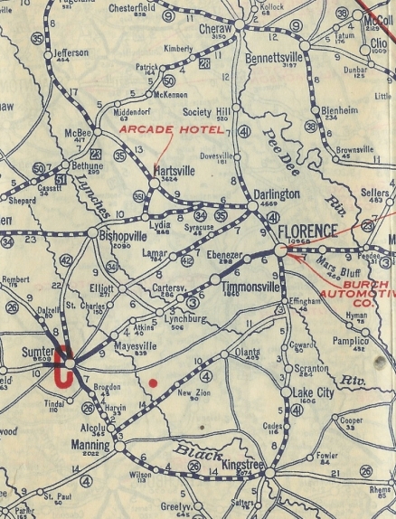
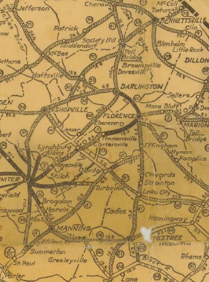
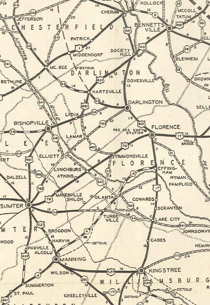
In 1925 or 1926, SC 30 was extended north with SC 4 from Santee to Summerton, north as new primary routing to Sumter, replaced SC 42 north to Bishopville, east with SC 34 Lydia, then replaced SC 351 north to Hartsville (SC 30 may have briefly used today's S-16-52 and S-16-65), then northeast as new primary routing through Society Hill to Bennettsville, then replaced SC 38 northeast to North Carolina at McColl.
In 1927, SC 30 south was truncated to Walterboro. Walterboro to Pocotaligo became part of US 17 (now US 17 ALT and S-7-3) while the rest to Beaufort became part of SC 28 (now US 21). In 1932, SC 30 was removed from today's S-16-366 and S-16-23 between Hartsville and Society Hill. In 1933, SC 30 was renumbered as US 401. Today this is US 15 except it crossed what is now Lake Marion 2 bridges to the west of I-95 (has the billboards on them); S-42-5 in Sumter; S-43-46 and S-43-325 over Whites Mill Pond; US 15 Business through Hartsville; S-35-167 and abandoned causeway at the Pee Dee River; SC 385, SC 385 CONN through Bennettsville.
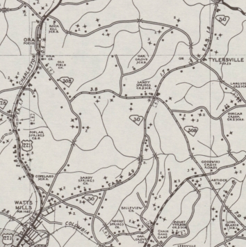
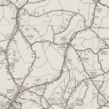
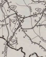
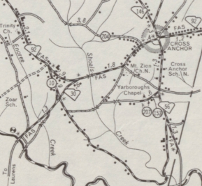
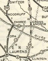
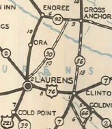
SC 30 #2: Appeared in 1935 as a renumbering of SC 15 from US 221 Watts Mill to SC 92 near Cross Anchor.
In 1947, SC 30 was rerouted on its north end to head east towards Cross Anchor, replacing SC 30 ALT. The old routing north to SC 92 became S-42-10. In 1950, SC 30 was given a new crossing of the Enoree River west of the original, leaving behind Deerwood Dr and Big Loop Rd.
In 1956, SC 30 was renumbered as SC 49.
|
||||||||||||||||||||||

Previous: SC 29 |
Next: SC 30 ALT | SC 31
Top | South Carolina Hwy Index
Home
Page last modified 19 March 2016