< TN 40 | Home | TN 42 >
|
|
|
| ROUTE LOG |
US 31W SB, US 41, TN 11: 0 - 0 I-65 (exit 98): 0.3 - 0.3 TN 257: 4.8 - 5.1 TN 258: 4.5 - 9.6 TN 76 WB: 0.7 - 10.3 TN 76 EB: 0.2 - 10.5 TN 25: 4.0 - 14.5 TN 52: 5.0 - 19.5 TN 109: 2.9 - 22.4 TN 259: 0.5 - 22.9 KY STATE LINE: 0 - 22.9
|
Creation: Appeared in 1927 or 1928 running generally as it does now. This was a renumbering of TN 79. This is the 2nd TN 41.
|
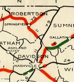
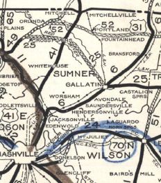
Adjustments: In 1932, TN 41 was removed from Old Louisville Hwy at its south end and rerouted to its current endpoint. In 1939, TN 41 was removed from C Smith Rd in Millersville; New Radar Rd (no longer connects to)/Woody Ln Jarrett Rd, Denson Ln and Florence Ln into White Hill In 1941, TN 41 was removed from "Old Hwy 31" and Meadowlark Rd near Rolling Acres In 1947, TN 41 was removed from "Old Hwy 31W" (no longer connects to) and South Rd in the TN 25 area; "Old Hwy 31W" at the Red River area; lengthy visible abandoned segment to the west from Old TN 52 EB to north of Byrum Chapel Rd; Old Hwy 31W in the Summers Branch area Posting: Completely unposted; only the segment between US 41 and I-65 is considered primary routing. Secret US Route Overlay: US 31W (entire route) Comment: With I-65 so close by, TN 41 is strictly local traffic these days. | Previous TN 41's:
|
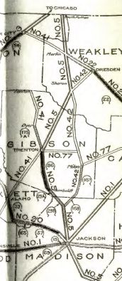
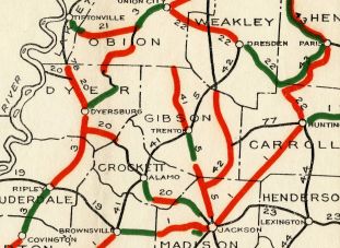
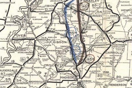
TN 41 #1: An original state highway described in the route log thusly: from Brownsville via Alamo, Trenton and Union City to a point near Martin. This is an odd description but in fact the 1924 map shows the route ending at Kenton, with no route at all continuing to Union City, but does show TN 41 running from Union City southeast to Martin.
In 1925 or 1926, TN 41 from Union City to Martin became part of TN 22 (now TN 431). In 1927 or 1928, TN 41 was renumbered as part of TN 54 from Brownsville to Trenton and TN 5 north of there. Today this is TN 54 to Trenton except: north of Alamo - Cherry St/Emerson Rd until it bends east; abandoned roadway northward; Malone Rd/Raleich Bird Rd; abandoned routing across the Middle Fork Deer River; Trenton Rd/Barber Rd/Old Alamo Rd, Layman Rd, a bit of Bill Edwards Rd; abandoned routing to TN 54 in the Frog Jump area; it appears the old route also used Lowery Ln Rd/TN 457/Poplar Corner Rd approaching Trenton; High St/Eaton St into downtown Trenton. This is TN 5 from Trenton to Kenton except: College St out of Trenton; Dyer Hwy and Main St through Dyer; Trenton St through Rutherford
| |||||||||||
Previous: TN 40 |
Next: TN 42
Top | Tennessee Hwy Index
Home
Page last modified 19 January 2021