< US 37 | Home | US 41 | US 41A Byp | US 41E >
| ||||||||||
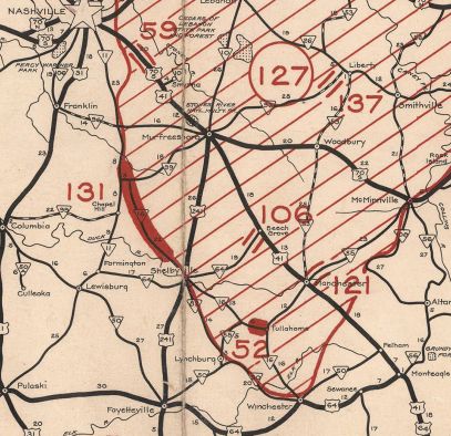
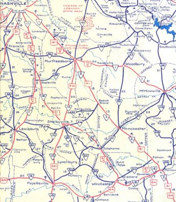
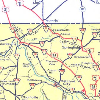
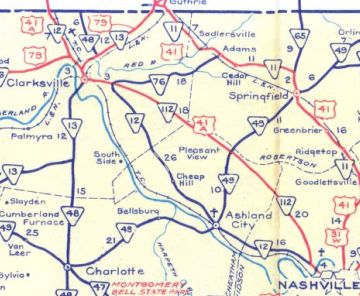
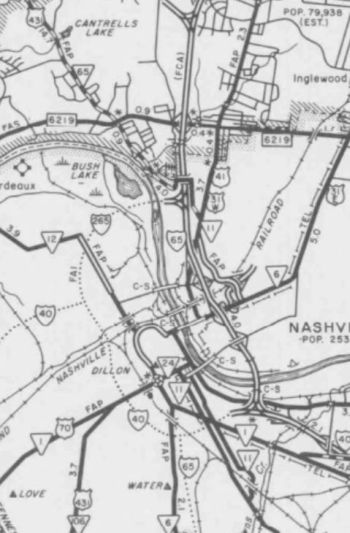
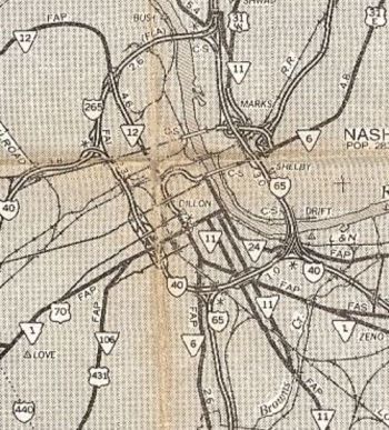
| ROUTE LOG US 41, TN 2, TN 15 Begin, TN 56 NB: 0 - 0 I-24 (exit 134), US 64, US 64 Bus Begin: 0.4 - 0.4 Franklin-Marion Line: 1.8 - 2.2 TN 156: 1.3 - 3.1 TN 56 SB: 2.5 - 5.6 US 64, TN 433: 9.4 - 15.0 US 64 Bus WB, TN 15 WB, TN 16 SB, TN 50 WB: 2.6 - 17.6 TN 50 EB: 1.7 - 19.3 TN 127: 0.9 - 20.2 TN 279: 4.2 - 24.4 Coffee-Franklin Line: 6.1 - 30.5 TN 55 NB, TN 130 SB: 1.1 - 31.6 TN 55 SB, TN 130 NB: 1.0 - 32.6 TN 269: 1.4 - 34.0 Moore-Coffee Line: 2.1 - 36.1 Bedford-Moore Line: 0.9 - 37.0 TN 276: 4.1 - 41.1 TN 437: 4.4 - 45.5 TN 64: 0.6 - 46.1 US 231 Bus, TN 10, TN 82: 3.4 - 49.5 US 231, TN 387: 0.6 - 50.1 TN 270: 7.2 - 57.3 Rutherford-Bedford Line: 10.4 - 67.7 TN 99 WB: 1.6 - 69.3 TN 99 EB, TN 269 EB: 1.0 - 70.3 TN 269 WB: 0.4 - 70.7 Williamson-Rutherford Line: 3.5 - 74.2 US 31 ALT SB, TN 11 SB, TN 16 END: 1.3 - 75.5 I-840 (exit 42): 2.7 - 78.2 TN 96: 0.6 - 78.8 Davidson-Williamson Line: 10.3 - 89.1 TN 253: 0.7 - 89.8 TN 254: 3.8 - 93.6 TN 255: 2.4 - 96.0 TN 155: 2.4 - 98.4 I-440 (exit 6): 0.9 - 99.3 I-40 (exit 210C), US 41 SB, US 70S EB, TN 1 EB: 2.2 - 101.5 US 31 SB, US 31 ALT END, TN 6 SB: 0.6 - 102.1 US 70, US 70S WB, US 431 SB, TN 1 WB, TN 24: 0.3 - 102.4 US 31 NB, US 41 NB, US 431 NB, TN 6 NB, TN 11 NB, TN 12 Begin: 0.7 - 103.1 I-65 (exit 85): 1.3 - 104.4 TN 12 NB, TN 112 Begin: 3.0 - 107.4 TN 155: 2.3 - 109.7 Cheatham-Davidson Line: 9.7 - 119.4 TN 249: 1.3 - 120.7 Robertson-Cheatham Line: 3.5 - 124.2 Cheatham-Robertson Line: 0.1 - 124.3 TN 49: 3.0 - 127.3 Robertson-Cheatham Line: 3.0 - 130.3 Cheatham-Robertson Line: 1.5 - 131.8 TN 256: 0.6 - 132.4 Montgomery-Cheatham Line: 1.5 - 133.9 US 41 ALT Byp, TN 76: 9.2 - 143.1 TN 374: 0.4 - 143.5 TN 48 NB: 4.6 - 148.1 TN 48 SB: 0.3 - 148.4 US 41 ALT Byp, US 79 NB, TN 12 SB, TN 13, TN 76 NB, TN 112 END: 0.8 - 149.2 US 79 SB, TN 76 SB: 1.5 - 150.7 TN 374: 2.7 - 153.4 TN 236: 3.4 - 156.8 KY STATE LINE: 0.8 - 157.6 |
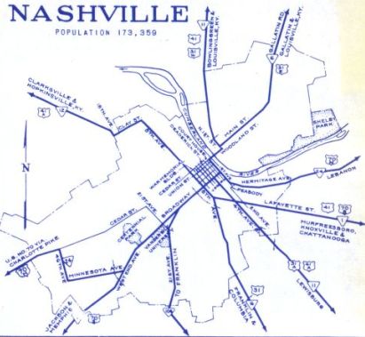
Creation: US 41A was approved as a US route in June 1944 (AASHO), though deferred from implementation until 1947 due to controversy surrounding the former US 41E and 41W designations (including the never-posted US 43 and a later desire to have the route via Clarksville be mainline US 41), running generally as it does now, following US 64 from Monteagle to Winchester; TN 16 from Winchester to Kirkland; TN 11 from Kirkland to Nashville
Adjustments: By 1954, US 41A was placed on one-way splits in central Clarksville - SB used the original route of 2nd St while NB used 3rd St/College In 1958, US 41A was placed on Robertson Pkwy in downtown Nashville, removing it from 8th Ave between Church St and where it leaves Robertson Pkwy. Between 1958-60, US 41A was rerouted in Nashville to use Lafayette to 8th.
By 1966, US 41A was placed on one-way splits in southern Nashville, with NB using Ensley Blvd/2nd Ave/Hart/3rd and SB using the original routing on 4th Ave. By 1975, US 41A NB in southern Nashville was rerouted to just Ensley/2nd. Between 1973-75, US 41A was removed from Clay St/Clarksville Pike in favor of Rosa Parks Blvd in northwestern Nashville
In the mid-1970s, US 41A was removed from the looping University Ave in Sewanee Posting: Fully posted, though poorly in Nashville, especially on its concurrency with US 41 Secret TN Route Overlay: TN 15 (17.6 mi) TN 16 (57.9 mi) TN 11 (27.6 mi) TN 12 I (4.3 mi) TN 112 (41.8 mi) TN 12 II (8.4 mi) Comment: US 41A provides a backdoor way from Monteagle to Nashville. When US 41 was moved onto the TN 150 alignment to provide an alternative to I-24 when it was having problems on the mountain, AASHO suggested Tennessee renumber US 41A as mainline US 41, which Tennessee declined to do. | |||||||||