< US 37 | Home | US 41 Bus | US 41A | US 41A Byp | US 41E >
|
|
|
|
| ROUTE LOG |
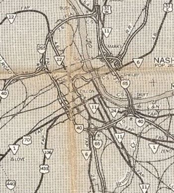
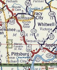
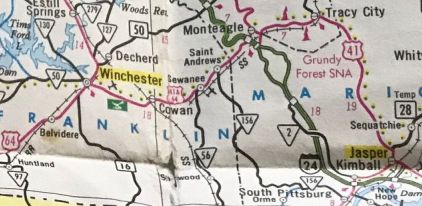
GA STATE LINE: 0 - 0 I-75 (exit 1): 1.0 - 1.0 I-24 (exit 181): 4.7 - 5.7 US 11 SB, US 64 WB, TN 2 SB: 0.1 - 5.8 US 11 NB, US 64 EB, TN 2 NB: 0.5 - 6.3 TN 17 NB: 0.5 - 6.8 US 76 WB, TN 27: 1.9 - 8.7 US 72 EB, TN 8 NB: 0.3 - 9.0 US 11 NB, US 64 EB, TN 2 NB: 0.1 - 9.1 I-24 (exit 178), US 27: 0.1 - 9.2 TN 17 SB: 1.3 - 10.5 TN 148: 1.0 - 11.5 TN 318: 1.1 - 12.6 US 11 SB, TN 38: 1.6 - 14.2 I-24 (exit 174): 0.2 - 14.4 Marion-Hamilton Line: 2.1 - 16.5 TN 134: 12.2 - 28.7 TN 27: 2.7 - 31.4 US 64 WB, US 72 WB, TN 2 WB, TN 28 SB, TN 150 SB: 3.1 - 34.5 TN 28 NB: 0.8 - 35.3 Grundy-Marion Line: 13.4 - 48.7 TN 56 NB, TN 150 END: 3.1 - 51.8 Marion-Grundy Line: 5.4 - 57.2 TN 2 SB: 0.1 - 57.3 US 41 ALT, TN 15, TN 56 SB: 0.8 - 58.1 Grundy-Marion Line: 0.1 - 58.2 TN 50: 6.7 - 64.9 Coffee-Grundy Line: 1.4 - 66.3 Grundy-Coffee Line: 0.1 - 66.4 Coffee-Grundy Line: 0.1 - 66.5 TN 127: 7.4 - 73.9 I-24 (exit 114): 5.6 - 79.5 TN 55: 2.1 - 81.6 TN 53: 1.1 - 82.7 I-24 (exit 105): 5.4 - 88.1 TN 280: 6.3 - 94.4 TN 64: 1.5 - 98.9 Rutherford-Coffee Line: 0.5 - 99.4 TN 99 EB: 16.2 - 115.6 US 70S EB, TN 1 EB, TN 2 END: 0.1 - 115.7 US 231 SB, TN 10 SB: 0.5 - 116.2 US 231 NB, TN 10 NB, TN 96, TN 99 WB: 0.7 - 116.9 TN 268: 2.4 - 119.3 I-840 (exit 55): 2.3 - 121.4 TN 102: 4.6 - 126.0 TN 266: 3.3 - 129.3 Davidson-Rutherford Line: 3.7 - 133.0 TN 171: 1.8 - 134.8 TN 254: 2.6 - 137.4 TN 255: 3.2 - 140.6 TN 155: 1.7 - 142.3 I-24 (exit 52): 2.0 - 144.3 US 31 ALT SB, US 41 ALT SB, TN 11 SB: 2.6 - 146.9 US 31 SB, US 31 ALT END, TN 6 SB: 0.6 - 147.5 US 70 WB, US 70S WB, US 431 SB, TN 1 WB, TN 24: 0.3 - 147.8 US 41 ALT NB, TN 12: 0.7 - 148.5 I-24 (exit 48): 1.2 - 149.7 US 31 END, US 31E, US 31W Begin, TN 6 NB: 0.1 - 149.8 US 31E, TN 6: 0.3 - 150.1 I-24 (exit 47): 0.2 - 150.3 US 431 NB, TN 65: 2.1 - 152.4 I-65 (exit 90): 2.3 - 154.7 TN 155: 0.2 - 154.9 TN 45: 2.2 - 157.1 TN 174: 4.6 - 161.7 Sumner-Davidson Line: 1.2 - 162.9 US 31W NB, TN 41: 0.3 - 163.2 Davidson-Sumner Line: 1.0 - 164.2 Robertson-Davidson Line: 3.5 - 167.7 TN 257: 0.5 - 168.2 US 431 SB, TN 65 SB: 8.8 - 177.0 TN 49, TN 76 EB: 1.3 - 178.3 US 431 NB, TN 65 NB: 1.5 - 179.8 TN 76 WB: 11.0 - 190.8 Montgomery-Robertson Line: 3.8 - 194.6 KY STATE LINE: 3.0 - 197.6
|
Creation: An original US route which was added to TN 8 from Georgia to Chattanooga; TN 27 from Chattanooga via Whitwell and Sequatchie to Jasper; TN 2 from Jasper through Manchester to Murfreesboro; TN 1 from Murfreesboro to Nashville; TN 12 from Nashville through Ashland City and Clarksville and on into Kentucky heading for Hopkinsville.
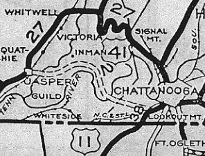
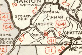
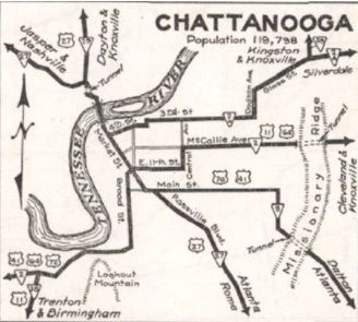
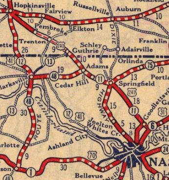
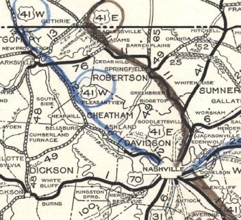
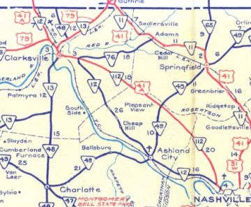
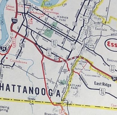
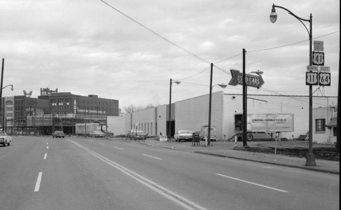
| Adjustments: By November 1927, Tennessee was calling the Nashville-Ashland City-Clarksville-Kentucky routing US 41W. AASHO eventually noticed US 41W on Tennessee maps and accepted their belated request to make this change in mid-1929. This truncated US 41 in Tennessee to 5th and Deaderick in Nashville. Today the route is still TN 12, except: in Nashville - 5th/Monroe St/9th north (through Kroger parkng lot now and also does not cross I-65)/Buchanan/18th (now Dr. Todd Blvd) to Clarksville Pile; John Mallette Dr in Bordeaux; abandoned routing west of TN 155 and Old Hydes Ferry Pike in Scottsboro; Old Ashland City Hwy west of Scottsboro; Old Hydes Ferry Pike and Caldwell Rd east of Ashland City; Chapmansboro Rd west of Ashland City; W Chetham School Rd near Cheap Hill; Bethel Rd/Mosley Ferry Rd/Old Hwy 12 in the Bethel area; Edwards Rd; Old Ashland City Hwy through Fredonia; E. Leonard Rd; Earl Rd; E Old Ashland City Rd and Old Ashland City Rd into Clarksville; Golf Club Ln/Madison St/2nd St through Clarksville; Duncan St/Walker St; Sinclair Rd; Old Hopkinsville Hwy (cutoff by TN 374) In 1928, US 41 was removed from Martin Gains Rd in Smithtown; Goff Payne Rd, abandoned routing, Cliff Payne Rd and also from abandoned routing on the east side at Fiery Gizzard Rd near Smithtown. In 1929, US 41 was removed from Old Ringgold Rd in Chattanooga and instead used the new Bachman Tunnel to Dodds Ave to Main St to Central Ave By 1930, US 41 was removed from Old Dixie Hwy and Nelson Rd in Kimball. In 1931 or 1932, US 41 was removed from TN 27 and instead routed along TN 2 from Chattanooga to Jasper. The old route remains TN 27 to Powells Crossroads except W Bell Ave in N. Chattanooga; today's TN 283 except a bit of Magnolia St and abandoned routing at the Sequatchie river west of Powells Crossroads; Valley View Hwy from Whitwell to Jasper except Shady Grove Rd in Sequatchie.
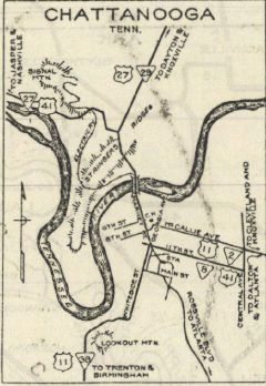
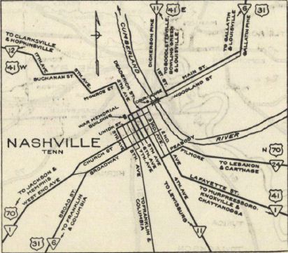
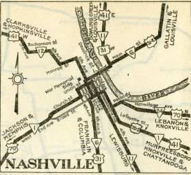
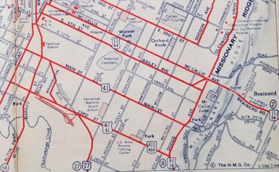
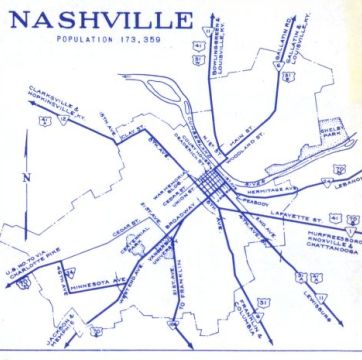
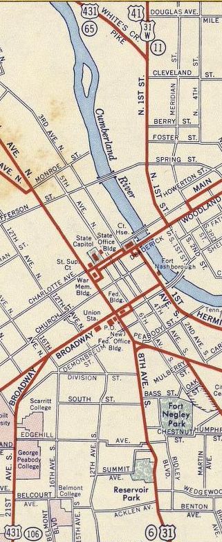
Also in 1931 or 1932, US 41 was rerouted in Chattanooga to use Main/Central/11th/Broad southward instead of Main/Central/11th/Market northward. Also in 1931 or 1932, US 41 was rerouted in Nashville. It originally ran Lafayette/2nd/Peabody/4th/Union/5th. Now it ran Lafayette/2nd/Broadway/4th/Union/6th/Deadrick. In 1935, AASHO officially changed US 41W to be part of US 41. Tennessee declined to sign the route this way (despite changing their route logs) and US 41E remained on the route. Also in 1935, US 41 was removed from Oscar Cromwell Rd in Beechgrove; Old Beechgrove Rd and Ferrell's Cemetery Rd Also about 1935, US 41 was removed from the two Kellys Ferry segments west out of Lookout Valley; also removed from today's TN 318 and Old Wauhatchie Pike (no longer continuous) In 1935 or 1936, US 41 was removed from Central Ave and instead used Main/Market/Broad in Chattanooga.
Also in 1935 or 1936, US 41 was rerouted in Nashville to use Lafayette/2nd/Peabody/1st to the new US 41E-41W split at 1st and Deadrick.
In 1940, US 41 was removed from French Brantley Rd southeast of Beechgrove and I believe also Old Murfreesboro Rd/Walter Barnes Ln (cutoff by I-24 from)/Busy Corner Ln In the early 1940s, the posted US 41 was truncated south to the new US 41E-41W split in Nashville at Broadway and 8th. In 1944, US 41 was actually posted to replace US 41E.
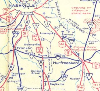
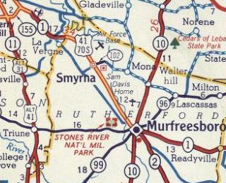
Between 1944-46, US 41 was removed from the lengthy Old Greenbrier Pike between TN 257 and Springfield. Between 1944-48, US 41 was rerouted in Nashville to use Lafayette/4th/1st/Woodland. By the 1950s, US 41 was apparently posted via 8th/Deadrick as well as Broadway/1st. About 1953, US 41 was removed from W. College St out of Murfreesboro and the lengthy Old Nashville Hwy to La Vergne. US 41 used part of today's Goodman Cir.
My guess is that US 41 was removed from Glover Hill Rd in Jasper in 1954. In the mid 1950s, US 41 was rerouted in Murfreesboro. Originally it ended at Main St at Maney Ave. Now, US 41 was removed from Maney and extended northwest on newly constructed Broad St to end at US 70S/TN 1 College St.
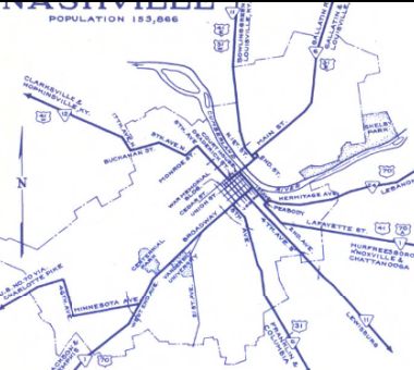
It is unclear when US 41 was removed from Mabee Ave in Monteagle but my guess is the 1950s. About 1956, US 41 was placed on Memorial Blvd through Springfield. The old route used routing abandoned to the east adjacent to the quarry and N Main St About 1958, US 41 was given its current route through Manchester. Originally it used Irwin/High/Spring/Fort/Woodland Sts. Although open about 1959, US 41 wasn't moved moved onto Robertson Pkwy in Nashville until later in the 1960s, per photos showing only US 31W-431. Between 1957-60, US 41 was changed to follow Main St directly to Broad St in Chattanooga. US 41 may have been given a bypass of Chattanooga in this action. Topo maps show a US 11-41-64 Byp that would've used US 27 south of Main then 23rd over to Dodd. Commercial maps showed this as US 11A-41A-64A. I have yet to find a Tennessee DOT map that shows this at all. However, there is a photo of a US 41 BUSINESS shield on Broad St NB north of Main St. If this really happened, it likely reverted back to using Broad to Main to Dodds when I-24 was completed by 1968.
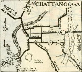
Between 1960-64, US 41 was removed from US 431/TN 161/Old 41N/S Garrett Rd/N Garrett Rd north of Springfield; also Dunn Rd at Cedar Hill. Also between 1960-64, US 41 was removed from Old Murfreesboro Rd in Una. Around 1964, US 41 was removed from Dixie Lee Ave and a piece of Bluebird Ln south of Monteagle and placed onto I-24 EB lanes. I-24 EB was built more or less on top of US 41 with just a few abandoned segments to smooth out some curves. At the bottom of the mountain, US 41 was removed from Martin Springs Rd on the east side of I-24 to just south of the current TN 2 exit. Not long after, US 41 was removed from TN 2 and placed on I-24 down to US 72 Kimball. In 1965, US 41 was removed from Deaderick St and N. 1st St and placed on the current viaduct over Cumberland River to nearly I-24, then placed on 5th St/Spring St/Dickerson Pike.
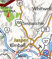
In 1976, US 41 was removed from the discontinuous Old State Hwy 11 and Old Hwy 41 loops northwest of Adams. In Oct 1979 (AASHTO), US 41 was rerouted at Jasper to follow TN 27 a short distance, then follow TN 150 to Tracy City, then TN 56 to Monteagle. The old route remained US 64-72 to Kimball and TN 2 to Monteagle. Around this time, AASHTO suggested that Tennessee reroute US 41 to replace all of US 41A south of Nashville. About 2018, US 41 was rerouted to leave US 64-72 at TN 28 then west over the new Jasper bypass. The old route remains US 64-72 in Jasper and Betsy Pack Dr.
Posting: Fully Posted Secret TN Route Overlay: TN 8 (9.0 mi) TN 17 (1.5 mi) TN 2 I (25.2 mi) TN 150 (17.3 mi) TN 56 (5.5 mi) TN 2 II (68.4 mi) TN 1 (31.2 mi) TN 11 (50.5 mi) Comment: Essentially usurped by I-65. | |||||||||||||||||||||||||||
Previous: US 27 |
Next: US 41 Bus | US 41A | US 41A Byp | US 41E
Top | Tennessee Hwy Index
Home
Page last modified 4 November 2023