< US 63 | Home | US 64 Bus | US 64 Byp | US 70 >
| ROUTE LOG AR STATE LINE: 0 - 0 I-55 SB (exit 12), TN 1 Begin: 0.5 - 0.5 US 61 SB, TN 14: 0.7 - 1.2 US 78 EB, TN 4: 0.4 - 1.6 TN 278: 0.9 - 2.5 US 51 NB, TN 1 NB, TN 3 NB: 0.3 - 2.8 I-240 (exit 30): 1.3 - 4.1 US 51 SB, US 72 Begin, TN 3 SB, TN 23 Begin: 0.2 - 4.3 US 72 EB, TN 23 EB, 277 SB: 2.1 - 6.4 TN 57 EB, TN 277 END: 0.5 - 6.9 TN 1 WB, TN 57 WB: 0.7 - 7.6 I-40 (exit 10): 5.4 - 13.0 US 70 EB, US 79 EB, TN 1 EB, TN 15 WB: 4.7 - 17.7 TN 177: 2.4 - 20.1 I-40 (exit 18): 1.1 - 21.2 I-269 (exit 15): 6.7 - 27.9 Fayette-Shelby Line: 1.0 - 28.9 TN 196: 3.1 - 32.0 TN 194: 4.1 - 36.1 TN 460: 7.1 - 43.2 TN 76: 2.4 - 45.6 Hardeman-Fayette Line: 10.7 - 56.3 US 64 Bus, TN 15 EB, TN 100 Begin: 1.5 - 57.8 TN 179: 0.5 - 58.3 US 64 Bus, TN 15 WB: 1.0 - 59.3 TN 100 EB: 0.2 - 59.5 TN 18 SB: 9.6 - 69.1 TN 18 NB, TN 125: 0.7 - 69.8 McNairy-Hardeman Line: 12.0 - 81.8 TN 225: 2.0 - 83.8 US 45 NB, US 64 Bus, TN 5 NB, TN 15 EB: 7.9 - 91.7 US 45 SB, US 64 Bus, TN 5 SB, TN 15 WB: 3.8 - 95.5 TN 224: 9.2 - 104.7 TN 22 NB, TN 117: 1.9 - 106.6 Hardin-McNairy Line: 1.2 - 107.8 TN 69 NB: 2.7 - 110.5 TN 22 SB: 0.2 - 110.7 TN 69 SB, TN 128 SB: 4.5 - 115.2 TN 226: 2.6 - 117.8 TN 128 NB: 2.6 - 120.4 Wayne-Hardin Line: 10.9 - 131.3 US 641, TN 114: 2.4 - 133.7 TN 13: 11.9 - 145.6 TN 99: 1.3 - 146.9 Natchez Trace Pkwy: 10.2 - 157.1 Lawrence-Wayne Line: 0.2 - 157.3 TN 240: 4.0 - 161.3 TN 241: 6.0 - 167.3 TN 242: 4.0 - 171.3 US 43, TN 6: 3.8 - 175.1 Giles-Lawrence Line: 7.7 - 182.8 TN 166 NB: 8.1 - 190.9 TN 11, TN 166 SB: 3.6 - 194.5 TN 166: 0.2 - 194.7 US 31, TN 7: 2.1 - 196.8 I-65 (exit 14): 8.6 - 205.4 Lincoln-Giles Line: 2.4 - 207.8 TN 244: 6.6 - 214.4 TN 273 WB: 6.9 - 221.3 US 64 Bus, TN 273 EB: 1.6 - 222.9 US 231 SB, US 431, TN 10 SB, TN 273: 2.2 - 225.4 US 64 Bus, US 231 NB, TN 10 NB, TN 50 WB: 1.6 - 227.0 TN 50 EB: 1.5 - 228.5 TN 275: 8.6 - 237.1 TN 121 SB: 2.9 - 240.0 TN 121 NB: 0.3 - 240.3 Franklin-Giles Line: 3.3 - 243.6 TN 122: 2.8 - 246.4 US 64 Bus, TN 15 EB, TN 433 Begin: 10.4 - 256.8 TN 16: 0.3 - 257.1 US 41 ALT, US 64 Bus, TN 15: 3.4 - 260.5 TN 50 WB, TN 433 END: 4.4 - 264.9 Grundy-Franklin Line: 9.4 - 274.3 Coffee-Grundy Line: 0.1 - 274.4 Grundy-Coffee Line: 0.6 - 275.0 I-24 WB (exit 127), TN 50 EB: 0.3 - 275.3 Marion-Grundy Line: 6.7 - 282.0 US 41 ALT, US 64 Bus, TN 16: 0 - 282.0 TN 2 NB: 1.3 - 283.3 TN 2 SB: 7.0 - 290.3 I-24 EB (exit 152), US 72 WB, TN 27, TN 150 Begin: 9.1 - 299.4 TN 2 NB: 0.2 - 299.6 US 41 NB, TN 28, TN 150 NB: 4.9 - 304.5 TN 27: 3.1 - 307.6 TN 134: 2.7 - 310.3 Hamilton-Marion Line: 12.2 - 322.5 I-24 (exit 174): 2.1 - 324.6 US 11 SB, TN 38: 0.2 - 324.8 TN 318: 1.6 - 326.4 TN 148: 1.1 - 327.5 TN 17 SB: 1.0 - 328.5 I-24 (exit 178), US 27: 1.3 - 329.8 US 41 SB, US 72 EB, TN 17 NB: 0.2 - 330.0 TN 27 NB, TN 58: 0.3 - 330.3 TN 27 SB: 0.9 - 331.2 US 41 SB, US 76 EB, TN 8 SB: 1.5 - 332.7 US 41 NB, US 76 WB, TN 8 NB: 0.5 - 333.2 TN 320: 4.7 - 337.9 TN 153: 1.7 - 339.6 TN 317 WB: 3.4 - 343.0 I-75 SB (exit 7), US 74 WB: 0.2 - 343.2 TN 317 EB: 1.5 - 344.7 I-75 NB (exit 11), US 74 EB: 2.6 - 347.3 TN 321: 0.6 - 347.9 Bradley-Hamilton Line: 3.3 - 351.2 US 64 Byp, US 74, TN 311: 6.4 - 357.6 US 11 NB, US 11 Bus Begin, TN 2 NB, TN 40 Begin: 2.4 - 360.0 US 11 Bus NB, TN 74 NB: 0.7 - 360.7 TN 74 SB: 0.4 - 361.1 US 64 Byp, US 74 WB, TN 60: 1.4 - 362.5 Polk-Bradley Line: 7.3 - 369.8 US 411, TN 33: 0.4 - 370.2 TN 314: 4.4 - 374.6 TN 30: 5.1 - 379.7 TN 68: 16.4 - 396.1 NC STATE LINE: 3.8 - 399.9 |
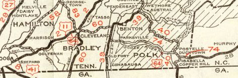
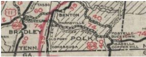
Creation: US 64 was an original US route but did not reach Tennessee. In 1932, US 64 was extended east with US 70 into Memphis from Arkansas, then to Bartlett; east with TN 15 through Selmer (US 70 to US 45 was a renumbering of US 72), Savannah, Waynesboro, Lawrenceburg, Pulaski to Fayetteville; replaced 16 through Winchester to Monteagle; then followed US 41 through Jasper to Chattanooga; then followed US 11 to Cleveland; east with TN 60 toward Benton; south with TN 39 briefly; then east with TN 74 through Ducktown to North Carolina.
 US 72 original western segment 1930 Official
 US 72 truncated to Selmer, replaced by US 64 1932 Official Adjustments: In 1934, US 64 was removed from TN 60 and TN 39 and instead placed on newly constructed TN 74 east out of Cleveland. Today the old routing is Central Ave/Shepherd St/6th St in Cleveland and Benton Pike east to Mull Rd south; US 411; Longley Rd.
About 1935, US 64 was removed from the two Kellys Ferry segments west out of Lookout Valley; also removed from today's TN 318 and Old Wauhatchie Pike (no longer continuous) By 1936, US 64 was removed from Old Stage Rd west of Crump. About 1937, US 64 was removed from Old Mill Rd and Williams Cove Rd/Money Ln east of Winchester. By 1938, US 64 was removed from Isabella Ave in Isabella which used to connect to TN 68/Five Point Dr intersection. Between 1939-47, US 64 was removed from Maple St in Sewanee In 1941, all of TN 74 from Cleveland to NC was renumbered as TN 40. Between 1941-47, US 64 was removed from Missouri Ave/Airport Rd/TN 156/Midway Rd east out of Sewanee. Northeast of Otter Falls Rd is abandoned. Between 1943-47, US 64 moved from 2nd St to 3rd St in Downtown Memphis.
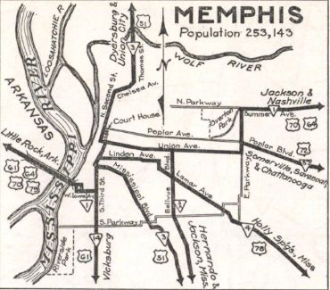
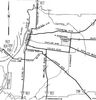
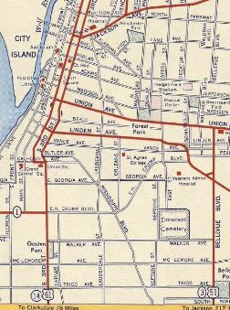
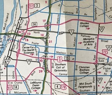
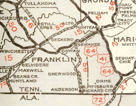
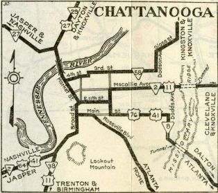
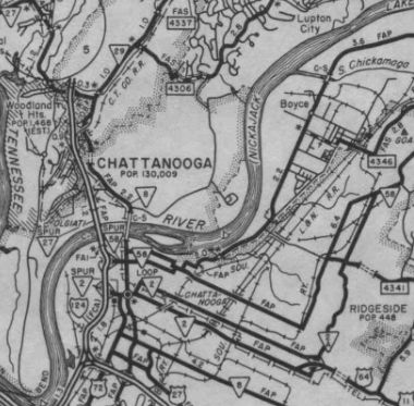
In 1949, US 64 was placed on the new Memphis-Arkansas bridge, leaving behind the Hanaran Bridge which is still open to foot/bicycle traffic. It is unclear when US 64 was removed from Mabee Ave in Monteagle but my guess is the 1950s My guess is that US 64 was removed from Glover Hill Rd in Jasper in 1954. In 1955, US 64 was removed from Old Waynesboro Hwy just west of Lawrenceburg Between 1952-56, US 64 was put on one-way routing through downtown Memphis, with EB using 3rd and WB using 2nd/Calhoun. In 1956 (bridge date), US 64 was given one-way splits in Chattanooga. EB used 11th/Central/Bailey/Doods (replacing TN 2A #2) while WB used the original alignment of McCallie/Central/9th/Georgia (this became TN 2 Loop on the TN route log) By 1961, the Chattanooga Splits were just Bailey EB and McCallie WB between Georgia and Dodds About 1962, US 64 was placed on I-75 between exits 7 and 11 northeast of Chattanooga. This created a split routing with NB using Bonnie Oaks Dr to access I-75 NB, while SB still used Lee Hwy on the west side of I-75 which had a ramp from I-75 SB about 3/4 of a mile north of Exit 7. This left behind Old Lee Hwy on the east side of the interstate. About 1962, US 64 was removed from a bit of Beckham Hollow Rd, then abandoned, twisting routing north of current US 64 to just short of Hardin Cr near Clifton Junction. About 1963, US 64 was removed from Moose Lodge Loop east of Savannah; Old Hwy 64 east of TN 128; Shady Grove Loop; Baptist loop in Olive Hill Around 1964, US 64 was removed from Dixie Lee Ave and a piece of Bluebird Ln south of Monteagle and placed onto I-24 EB lanes. I-24 EB was built more or less on top of US 64 with just a few abandoned segments to smooth out some curves. At the bottom of the mountain, US 64 was removed from Martin Springs Rd on the east side of I-24 to just south of the current TN 2 exit. Also about 1964, US 64 was placed on its Whiteville Bypass, leaving behind TN 15 (now also US 64 Business). About 1968, US 64 was removed from Cherokee Trail and Five Point Dr into Ducktown; Old US 64 at the NC Line; plus several abandoned alignments in the Ocoee lake area as US 64 was straightened out. Also around 1968, US 64 was rerouted just west of the Tennessee River bridge Haletown to accommodate Nickajack Lake. Only a small bit of the original route within Marion County Park is not underwater. In response to the 1968 Federal Highway Act, Tennessee requested an interstate corridor along US 64 from I-75 to North Carolina. This was not approved. In 1969, US 64 was removed from abandoned route/Fortyeight Creek Rd/abandoned route well east of Waynesboro About 1972, US 64 was placed onto I-24 around Monteagle. This left behind US 41 ALT/TN 2 into Monteagle and US 41/TN 2 out of Monteagle. In the mid-1970s, US 64 was removed from the looping University Ave in Sewanee In the late 1970s, US 64 was removed from TN 99/Old US Hwy 64 east of Waynesboro; South Curve Rd; Old State Hwy 15; Mrs Gower Rd west of Ovilla. About 1983, US 64 was routed around Downtown Memphis using Danny Thomas from Union to Crump. The old routing on Union remained TN 3 and 2nd/3rd remained TN 14.
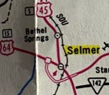
About 1987, US 64 was placed on its Selmer Bypass, leaving behind US 64 Business.
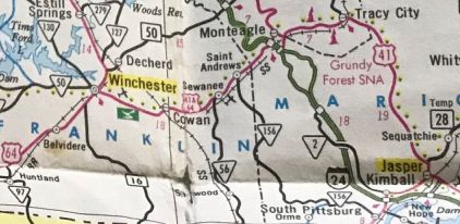
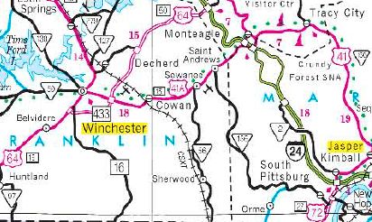
In 1993, US 64 was removed from Old Hwy 64 through Frankewing and McBurg In May 1995 (AASHTO), US 64 was given its Winchester bypass, plus rerouted over TN 50 to I-24 near Pelham, following I-24 back to Monteagle. The old route through Winchester became US 64 Business and from the bypass east through Sewanee to Monteagle remained US 41 ALT/TN 15.
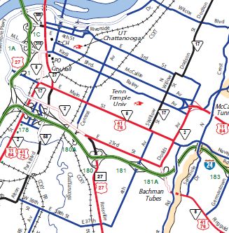
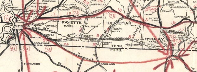
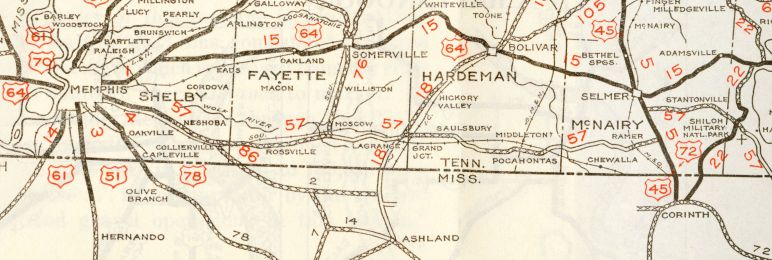
In 1995, US 64 was given its bypass around the south of Pulaski, leaving behind College St (a little of this remained part of TN 11). About 1998, US 64 was removed from Horseshoe Rd in Taylortown; Turner Rd near Egam; Wilson Rd at TN 273 junction area About 1999, US 64 was removed from the lengthy Old Hwy 64 between TN 100 and Bolivar. Also about 1999, US 64 was removed from Savannah Hwy/High St/Hill St/Woods Blvd through Waynesboro. 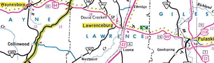 US 64 bypassing Waynesboro and Pulaski 2001 Official About 2000, US 64 was removed from Aymett Town Rd and Five Points Rd; McAfee Rd and an unnamed loop just west of I-65. In 2001, US 64 was removed from Poplar Ave near the US 45-64 split south of Selmer. About 2004, US 64 was removed from central Chattanooga entirely by using 20th/23rd/Dodds. The old routing into downtown remains part of US 72 and TN 8. Leaving downtown on its former one-way pairs is no longer in the state highway system.
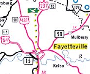
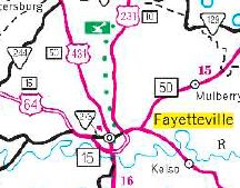
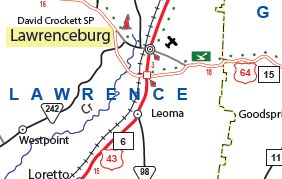
Also about 2004, US 64 was removed from Lee Hwy north of Exit 7 on I-75 as the far flung ramp was removed and new ramps were installed right at Exit 7. In 2004 or 2005, US 64 was placed on the long-existing loop around the south of Fayetteville, leaving behind TN 273 and TN 50 (now US 64 Business).
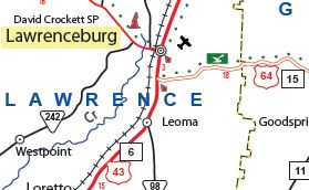
In 2006, US 64 was removed from Arch Loop east of Olive Hill Also about 2006, US 64 was removed from Scenic Rd west of TN 240; Waynesboro Hwy east of TN 241. Also about 2006, US 64 was removed from Belvidere Rd in Belvider and Old Crockett Hwy approaching Winchester. About 2009, US 64 was removed from Lawrenceville Hwy at the Giles/Wayne line area Also about 2009, US 64 was removed from Gum Springs Church Rd and Old Winchester Hwy in the TN 121 vicinity. About 2010, US 64 was given the eastern half of its bypass around the south of Lawrenceburg, leaving behind Pulaski Hwy. US 64 used US 43 to get back to the original US 64 routing. About 2010, US 64 was removed from Main St through Hornsby About 2012, US 64 was removed from Waynesboro Hwy between TN 240 and TN 241 About 2014, US 64 was placed on the western half of the Lawrenceburg Bypass, leaving behind US 45 and Gaines St (some of which is TN 242).
Posting: Fully posted but poorly posted in Downtown Memphis. The turns involving Danny Thomas are unmarked in all directions. Secret TN Route Overlay: TN 1 I (2.3 mi) TN 3 (1.5 mi) TN 23 (2.1 mi) TN 277 (0.5 mi) TN 57 (0.7 mi) TN 1 II (10.1 mi) TN 15 I (40.1 mi) TN 100 (1.5 mi) TN 15 II (32.4 mi) TN 5 (3.8 mi) TN 15 III (171.3 mi) TN 433 (8.1 mi) TN 50 (10.4 mi) TN 150 (0.2 mi) TN 2 (60.4 mi) TN 40 (39.9 mi) Comment: US 64 has been upgraded to multilane highway from Bartlett all the way across the state to I-24. East of Cleveland, US 64 is part of Appalachian Corridor K and is 4-lane improved from Cleveland to Ocoee and Ducktown to NC. The 25 miles in between follows the narrow path of the Ocoee River and upgrading this segment to modern 4-lane standards will be a tall and expensive task. Both the 2013 and 2019 versions of ADHS Corridor update documents say that the Ocoee River section is under location/environmental study. | ||||||||||||||||||