| I-85 233 miles |
|
|
|
|
| The Road: |
|
Begins at the South Carolina State line at Grover (Cleveland County) and ends at the Virginia State Line near Norlina (Warren County).
Nationally I-85 runs from I-65 Montgomery AL to I-95 Petersburg VA
|
Towns and Attractions: |
|
Cleveland Co.: Kings Mountain
Gaston Co.: Gastonia, McAdenville, Belmont
Mecklenburg Co.: Charlotte
Cabarrus Co.: Concord, Kannapolis
Rowan Co.: China Grove, Salisbury
Davidson Co.: Lexington, Thomasville
Randolph Co.: Archdale
Guilford Co.: High Point, Greensboro
Alamance Co.: Burlington, Graham
Orange Co.: Hillsborough
Durham Co.: Durham
Granville Co.: Butner, Oxford
Vance Co.: Henderson
Warren Co.: None
|
History: |
|
Many of the following timelines are from North Carolina's I-85 entry on their 50th anniversary of interstates website.
I-85 was an original 1957 interstate.
The first segment to open was in Sept 1958 from Little Rock Rd to the US 29 Connector (Bypass of Charlotte)
In 1959, I-85 was open from China Grove to NC 150 north of the Yadkin River
In 1960 the following segments were open:
1. US 29 to US 74 (Kings Mtn bypass)
2. NC 273 to Little Rock Rd
3. Yadkin River to Greensboro (this was the 4-laned US 29-70 from the early 1950s that now had enough grade separations to be called I-85)
4. Greensboro to Efland (this was a Super-2 alignment of US 70 from about 1957)
5. Henderson to US 1 at the Virginia Line (may have been NC 293 briefly).
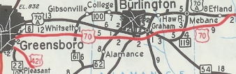 US 70 Greensboro to Efland
1958 Official
|
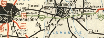 I-85 Greensboro to Efland
1960 Official
|
The 1961 Official shows I-85 open from the South Carolina line to US 29 (exit 4); also from Efland to the east end of the Durham Bypass. Note that the segment from the Yadkin River to Greensboro was shown as I-85 TEMP on the 1961 official map.
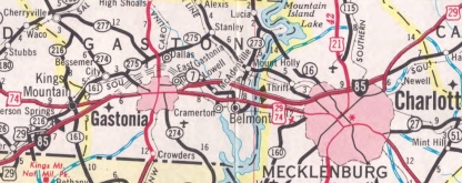
The 1963 Official shows I-85 open from US 29-74 Connector east of Gastonia to NC 273
The 1964 Official shows I-85 open from US 29-74 Kings Mtn to the US 29-74 Connector (Gastonia Bypass).
 I-85 open around Charlotte
1959 Official
|
 I-85 open at Kings Mtn
1960 Official
|
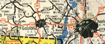
 I-85 open around Grover
1961 Official
|
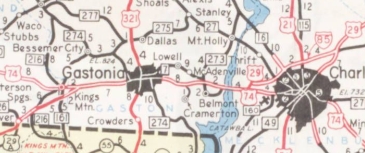
 I-85 open east of Gastonia
1963 Official
|
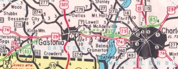
 I-85 open around Gastonia
1964 Official
|
The 1966 Official shows I-85 open from US 1 across the Virginia line and also US 70 east of Durham north to the US 15 North split.
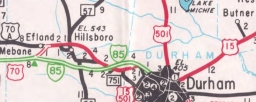 I-85 open Efland to Durham
1961 Official
|
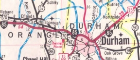 I-85 open Durham to Granville Co
1966 Official
|
The 1970 Official shows I-85 open from US 29-601 Concord to China Grove.
The 1971 Official shows I-85 open from the US 29 Connector that is now part of I-485 to US 29-601 Concord; also from US 15 Oxford to Henderson (from US 15 to US 158 Oxford had been built as a bypass of Oxford designated US 158-A in the late 1950s).
The 1972 Official shows I-85 open between the two US 29 Connectors northeast of Charlotte.
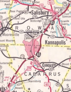
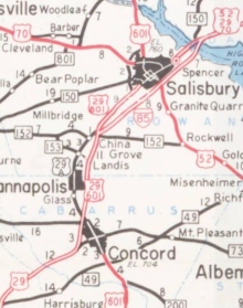 I-85 open around Salisbury
1959 Official
|
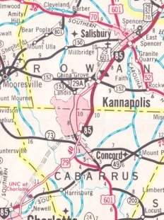 I-85 open around Kannapolis
1970 Official
|
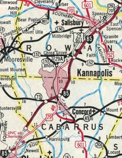 I-85 open around Concord
1971 Official
|
 I-85 open around UNC-Charlotte
1972 Official
|
Also in 1972, I-85 was shown open between US 15 north of Durham and US 15 Oxford. This completed I-85 in North Carolina except for the portion designated as I-85 Temp through Thomasville, Lexington, and High Point. Notably, from 1972 onward, I-85 Temp was no longer shown as an interstate on officials...just a 4-lane road. From 1961-71 this was shown as an interstate.
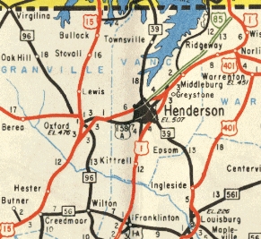 I-85 open north of Henderson
1960 Official
|
 I-85 open from Oxford to Henderson
1971 Official
|
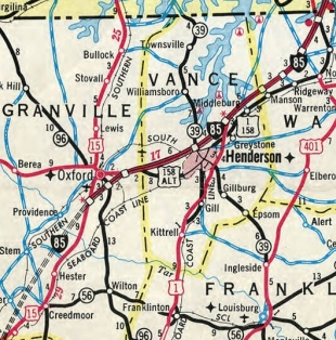
 I-85 open from Durham Co to Oxford
1972 Official
|
In 1984, I-85 was built between the Yadkin River area and north of High Point, alleviating the need of an I-85 Temp designation.
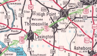 I-85 TEMP appears from Yadkin River to Greensboro
1961 Official
|
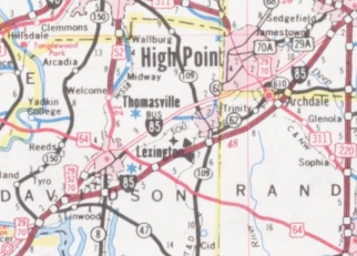 I-85 open from Yadkin River to Greensboro
1985 Official
|
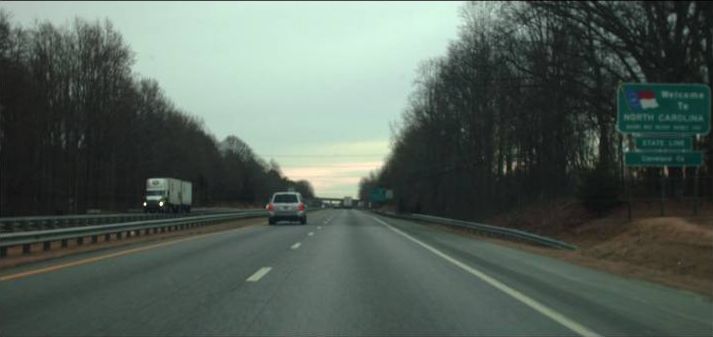
In 2005, I-85 was placed on the new southern beltway of Greensboro, leaving behind I-85 Business.
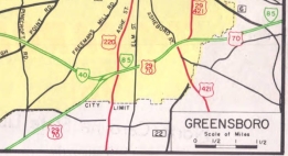 I-85 through central Greensboro
1961 Official
|
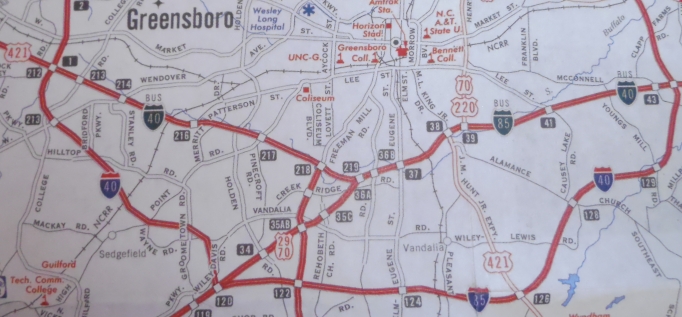 I-85 bypasses central Greensboro
2008 Official
|
|
Comments: |
|
The NCDOT 50th anniversary page notes that in 1963, NCDOT requested three interstate corridors described as spurs of I-85: what is now NC 147, the east end connector and US 70 back to I-85; I-40 from NC 147 and over Wade Ave to the Raleigh Beltline; US 220 between I-85 Bus and I-40 plus still unbuilt roadway north to Lee Ave.
I-85 crosses over itself for around 3 miles between US 64 and NC 109 in Davidson County. Presumably this was because Hamby Creek was in the way. There is a left exit rest area in both directions along this segment, but because of the creek, they are two totally separate rest areas, unlike most left exit rest areas that build a slightly larger rest area to accomodate both sides.
I-85 is easily North Carolina's most important highway as it connects several large NC economic centers and cities. It won't be much longer before it will be at least 6 lanes nearly continuously from Gastonia to Durham. It is 8 lanes from east of Greensboro to Hillsborough.
|
Exit List: |
|
EXIT 2: NC 216
EXIT 4 (SB only): US 29 SOUTH
EXIT 5: SR 2283 Dixon School Rd
EXIT 8: NC 161
EXIT 10: US 29 NORTH, US 74
EXIT 13: SR 1307 Edgewood Rd
EXIT 14: NC 274
EXIT 17: US 321
EXIT 19: NC 7
EXIT 20: NC 279
NO EXIT #?: US 29-74 Connector (exit removed)
EXIT 21: SR 2200 Cox Rd
EXIT 22: SR 2000 Main St
EXIT 23: NC 7
EXIT 26: NC 7
EXIT 27: NC 273
EXIT 29: SR 1625 Sam Wilson Rd
EXIT 30: I-485
EXIT 32: SR 1641 Little Rock Rd
EXIT 33: Billy Graham Pkwy
EXIT 34: NC 27
EXIT 35: Glenwood Rd
EXIT 36: NC 16
EXIT 37: SR 2074 Beatties Ford Rd
EXIT 38: I-77, US 21
EXIT 39: Statesville Ave
EXIT 40: SR 2540 Graham Rd
EXIT 41: SR 2480 Sugar Creek Rd
EXIT 42: US 29/NC 49 Connector
EXIT 43: University City Blvd
EXIT 45: NC 24
EXIT 46: SR 2472 Mallard Creek Rd
EXIT 48: I-485
EXIT 49: Bruton Smith Blvd
EXIT 52: SR 1394 Poplar Tent Rd
EXIT 54: SR 1430 Kannapolis Pkwy
EXIT 55: NC 73
EXIT 58: US 29, US 601 SOUTH
EXIT 60: SR 2126 Dale Earnhardt Blvd
EXIT 63: SR 2180 Lane St
EXIT 68 (NB only): NC 152
EXIT 68 (SB only): SR 2664 US 29 Connector
EXIT 70: SR 1500 Webb Rd
EXIT 71: SR 2538 Peeler Rd
EXIT 72: SR 2539 Peach Orchard Rd
EXIT 74: SR 2528 Julian Rd
EXIT 75: US 601 NORTH
EXIT 76: US 52 SOUTH
EXIT 79: SR 1915 Andrews St
EXIT 81: SR 2120 Long Ferry Rd
EXIT 82 (SB only): US 29 SOUTH, US 70 WEST, NC 150 WEST
EXIT 84: NC 150 EAST
EXIT 85: SR 1295 Clark Rd
EXIT 86: SR 1183 Belmont Rd
EXIT 87: I-85 Bus, I-285, US 29 NORTH, US 52 NORTH, US 70 EAST
EXIT 88: NC 47
EXIT 91: NC 8
EXIT 94: SR 2205 Old Raleigh Rd
EXIT 96: US 64
EXIT 102: SR 2085 Lake Rd
EXIT 103: NC 109
EXIT 106: SR 1547 Finch Farm Rd
EXIT 108: SR 1558 Hopewell Church Rd
EXIT 111: SR 1993 S. Main St
EXIT 113: NC 62
EXIT 113B-C: I-74, US 311
|
EXIT 118 : I-85 Bus, US 29 SOUTH
EXIT 119 (NB only): SR 1129 Groometown Rd
EXIT 120 (NB only): I-73 NORTH, I-85 Bus, US 29 NORTH, US 421 NORTH
EXIT 121 (SB only): I-73 NORTH, US 421 NORTH
EXIT 122A (SB only): SR 1129 Groometown Rd
EXIT 122B-C (SB only): I-73 SOUTH, US 220
EXIT 124: SR 3300 Elm-Eugene St
EXIT 126: US 421 SOUTH
EXIT 128: SR 1005 Alamance Church Rd
EXIT 129: SR 3029 Youngs Mill Rd
EXIT 131 (NB only): I-785, I-840
EXIT 131 (SB only): I-40 WEST, I-85 Bus
EXIT 132: SR 3045 Mt. Hope Church Rd
EXIT 135: SR 3056 Rock Creek Dairy Rd
EXIT 138: NC 61
EXIT 140: University Dr
EXIT 141: SR 1149 Huffman Mill Rd
EXIT 143: NC 62
EXIT 145: NC 49
EXIT 147: NC 87
EXIT 148: NC 54
EXIT 150: SR 1928 Jimmie Kerr Rd
EXIT 152: SR 1981 Trollingwood Hawfields Rd
EXIT 153: NC 119
EXIT 154: SR 1007 Mebane Oaks Rd
EXIT 157: SR 1114 Buckhorn Rd
EXIT 160: SR 1120 Mt. Willing Rd
EXIT 161: SR 1279 Interstate 85 Connector
EXIT 163: I-40 EAST
EXIT 164: SR 1009 Old NC 86
EXIT 165: NC 86
EXIT 170: US 70 WEST, US 70 Bus
EXIT 172 (NB only): NC 147
EXIT 173: SR 1401 Cole Mill Rd
EXIT 174A (SB only): US 15 SOUTH, US 501 SOUTH
EXIT 174: SR 1321 Hillendale Rd
EXIT 175: NC 157
EXIT 176: US 501 NORTH
EXIT 177: US 15 Bus, US 501 Bus, NC 55
EXIT 178: US 70 EAST
EXIT 179: SR 1671 Club Rd
EXIT 180: SR 1675 Glenn School Rd
EXIT 182: SR 1632 Red Mill Rd
EXIT 183: SR 1637 Redwood Rd
EXIT 186: US 15 NORTH
EXIT 189: SR 1103 Gate 2 Rd
EXIT 191: NC 56
EXIT 202: US 15
EXIT 204: NC 96
EXIT 206: US 158
EXIT 209: SR 1126 Poplar Creek Rd
EXIT 212: SR 1128 Ruin Creek Rd
EXIT 213 (NB only): SR 1162 Dabney Rd
EXIT 213 (SB only): US 158 WEST
EXIT 214: NC 39
EXIT 215 (NB only): US 158 EAST
EXIT 215 (SB only): SR 1312 Parham Rd
EXIT 217: SR 1319 Satterwhite Point Rd
EXIT 218 (SB only): US 1 Connector
EXIT 220: US 1, US 158
EXIT 223: SR 1237 Manson-Drewry Rd
EXIT 226: SR 1224 Ridgeway-Drewry Rd
EXIT 229: SR 1210 Oine Rd
EXIT 233: US 1, US 401
|
| |
|