< US 58 | Home | US 60E >
US 60 | US 60 ALT | US 60 Bus | US 60 Spur | US 60-Y
| US 60-Z not currently assigned | ||||||
| Previous US 60-Z's: 1973 ROUTE LOG US 60: 0 - 0 VA 5 WB, VA 31 SB, VA 132: 1.35 - 1.35 US 60, VA 5 EB, VA 31 NB: 1.15 - 2.50 |
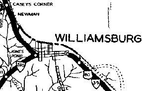
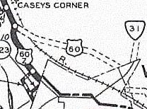
US 60-Z: Appeared in December 1934 as a renumbering of US 60
through Williamsburg. initially it ran along Richmond Rd (old VA 162
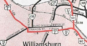
endpoint) straight to central Williamsburg, then Duke of Gloucester St
east then south around the Old Capitol using Blair, Francis and Waller
Sts to York St east out of town
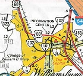
It appears that in July 1940 (CTB) US 60-Z was rerouted off Duke of Gloucester St to instead use France St and Francis St. In 1974, US 60-Z became VA 132 west of central Williamsburg (then later VA 162 but now unnumbered) and the multiplexed routes of VA 5 and VA 31 (now just VA 5).
US 60-Z didn't appear on Officials until 1958 but did appear on the 1936 James City County Map. I have yet to see a photo showing how US 60-Z was actually posted (if it even was). |
|||||
Previous: US 58 |
Next: US 60E
Top | Virginia Hwy Index
Home
Page last modified 11 February 2022