< TN 1 | Home | TN 2A | TN 2 Bus | TN 2 Byp | TN 2 Loop | TN 2 Spur | TN 3 >
|
|
|
| ROUTE LOG |
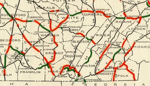
US 41 NB, US 70S, TN 1, TN 99 WB: 0 - 0 TN 99 EB: 0.1 - 0.1 Coffee-Rutherford Line: 16.2 - 16.3 TN 64: 0.5 - 16.8 TN 280: 1.5 - 18.3 I-24 (exit 105): 6.3 - 24.6 TN 53: 5.4 - 30.0 TN 55: 1.1 - 31.1 I-24 (exit 114): 2.1 - 33.2 TN 127: 5.6 - 38.8 Grundy-Coffee Line: 7.4 - 46.2 Coffee-Grundy Line: 0.1 - 46.3 Grundy-Coffee Line: 0.1 - 46.4 TN 50: 1.4 - 47.8 Marion-Grundy Line: 6.7 - 54.5 US 41 ALT, TN 15, TN 56 SB: 0.1 - 54.6 US 41 SB, TN 56 NB: 0.8 - 55.4 I-24 WB (exit 135), US 64 WB: 0.6 - 56.0 I-24 EB (exit 143), US 64 EB: 7.0 - 63.0 US 64 WB, US 72 WB, TN 150 SB: 12.6 - 75.6 US 41 NB, TN 28, TN 150 NB: 4.9 - 80.5 TN 27: 3.1 - 83.6 TN 134: 2.7 - 86.3 Hamilton-Marion Line: 12.2 - 98.5 I-24 (exit 174): 2.1 - 100.6 US 11 SB, TN 38: 0.2 - 100.8 TN 318: 1.6 - 102.4 TN 148: 1.1 - 103.5 TN 17 SB: 1.0 - 104.5 I-24 (exit 178), US 27: 1.3 - 105.8 US 41 SB, US 72 EB, TN 17 NB: 0.2 - 106.0 TN 27 NB, TN 58: 0.3 - 106.3 TN 27 SB: 0.9 - 107.2 US 41 SB, US 76 EB, TN 8 SB: 1.5 - 108.7 US 41 NB, US 76 WB, TN 8 NB: 0.5 - 109.2 TN 320: 4.7 - 113.9 TN 153: 1.7 - 115.6 TN 317 WB: 3.4 - 119.0 I-75 SB (exit 7), US 74 WB: 0.2 - 119.2 TN 317 EB: 1.5 - 120.7 I-75 NB (exit 11), US 74 EB: 2.6 - 123.3 TN 321: 0.6 - 123.9 Bradley-Hamilton Line: 3.3 - 127.2 US 64 Byp, US 74, TN 311: 6.4 - 133.6 US 11 Bus, US 64 EB, TN 40: 2.4 - 136.0 TN 312: 0.4 - 136.4 TN 60: 1.5 - 137.9 US 11 Bus, TN 74: 1.9 - 139.8 TN 308: 6.9 - 146.7 McMinn-Bradley Line: 1.5 - 148.2 TN 163 EB: 0.5 - 148.7 TN 163 WB: 0.6 - 149.3 US 11 Bus, TN 39 EB: 6.4 - 155.7 TN 39 WB: 0.2 - 155.9 TN 30: 5.9 - 161.8 US 11 Bus, TN 305: 2.7 - 164.5 TN 309: 3.9 - 168.4 Monroe-McMinn Line: 4.4 - 172.8 TN 68: 2.0 - 174.8 TN 322: 1.7 - 176.5 Loudon-Monroe Line: 5.0 - 181.5 TN 323: 1.3 - 182.8 TN 72: 3.4 - 186.2 TN 324: 4.9 - 191.1 US 321, TN 95: 3.7 - 194.8 US 11 NB, US 70, TN 1: 5.1 - 199.9
|
Creation: Appeared in 1923 as an original state highway, running generally the way it does now.
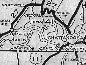
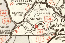
|  TN 2 is a giant V 1926 Official Adjustments: By 1925 (bridge date), TN 2 was removed from Sam Goodwin Dr/Old Chattanooga Dr (no lomger a through road) in the McDonald area and Old Chattanooga Pike/(no lomger connects to) Kile Ln/S Ocoee St into Cleveland. Also in 1925, TN 2 was removed from Farrell St through Niota and beyond; also Greenhouse Rd and abandoned routing; also Browder Church Rd at the McMinn/Monroe line In late 1926, US 41 was added to TN 2 from Murfreesboro to Jasper and US 11 was added from the Lookout Mtn area to Dixie Lee Junction. In 1927 (Nat'l Archive), TN 2 was removed from Walker Valley Rd and Worth Ln between Cleveland and Charleston. In 1928, TN 2 was removed from Martin Gains Rd in Smithtown; Goff Payne Rd, abandoned routing, Cliff Payne Rd and also from abandoned routing on the east side at Fiery Gizzard Rd near Smithtown. About 1929, TN 2 was rerouted between Jasper and the Lookout Mountain area. Originally, TN 2 followed the unnamed alignment just west of modern TN 28 and just east of it; E. Valley Rd through Ebenezer; today's TN 27 to Mineral Springs; abandoned routing; Bennetts Lake Rd; Mullins Cove Rd for about 10 miles to the former Kelly's Ferry across the Tennessee River; abandoned routing parallel to current TN 2 to just east of the Kelly's Ferry Church. Now TN 2 followed its current routing, generally speaking.
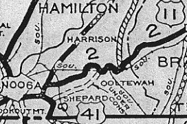
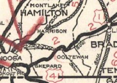
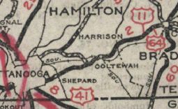
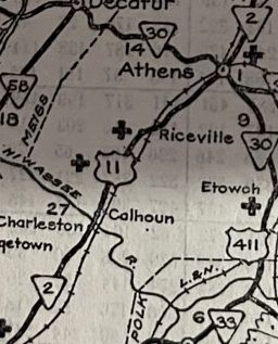
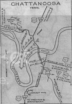
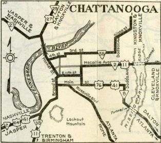
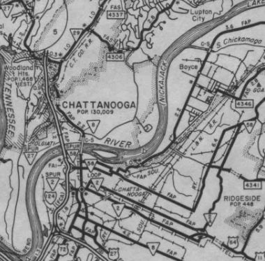
Also about 1929, TN 2 was placed on today's Lee Hwy between Chattanooga and Summit. The old route eventually became the TN 2A corridor which was realigned in the 1930s. Today it is TN 17; Campbell St, Lightfoot Mill Rd; TN 317 (except TN 2 used abandoned routing between Noah Reid Rd and Bonnyvale Ln); Old Cleveland Pike (now ends at RR track); abandoned routing along north side of the RR; Old Cleveland Pike (just south of Volkswagon Dr interchange with I-75) By 1930, TN 2 was removed from Old Dixie Hwy and Nelson Rd in Kimball. In 1929 or 1930, TN 2 was rerouted in Chattanooga from Whiteside (this is Broad today)/Main/Cowart/Market/8th/Georgia/McCallie to Whiteside/11th/Central/McCallie. In 1930 (bridge date), TN 2 was removed from Old Niota Rd out of Athens, plus a routing that is now essentially covered by TN 305 and US 11 (plus Club House Dr). Also about 1930, TN 2 was removed from Browder School Rd/Huntsville Hollow Rd, plus Old Loudon Pike into Lenoir City In 1931, TN 2 was put on new alignment between Bashaw Creek Rd across the Duck River to about Hendrixson Dr, leaving behind abandoned routing to the south. Also in 1931 (bridge date), TN 2 was removed from Old Athens Pike/High St/Mayes Ave (no longer continous)/Old US 11 through Sweetwater; also Ol Lee Hwy/Elm St through Philadelphia In 1931 or 1932, TN 2 was extended over TN 1 from Old Stage Rd to the new Lee Hwy routing at Dixie Lee Jct. In 1931 or 1932, TN 2 was placed on current Old Lee Hwy and US 11-64 from Summit through the Ooltewah area. The old route is more Old Cleveland Pike (cut off by TN 317); Ooltewah Cemetary Rd/Jack Cate Rd/Lodge Ln/Railroad Ave/TN 321.
In 1935, TN 2 was removed from Oscar Cromwell Rd in Beechgrove; Old Beechgrove Rd and Ferrell's Cemetery Rd Also about 1935, TN 2 was removed from the two Kellys Ferry segments west out of Lookout Valley; also removed from today's TN 318 and Old Wauhatchie Pike (no longer continuous) In 1940, TN 2 was removed from French Brantley Rd southeast of Beechgrove and I believe also Old Murfreesboro Rd/Walter Barnes Ln (cutoff by I-24 from)/Busy Corner Ln Also in 1940, TN 2 received its current routing through Charleston/Calhoun. The old route used Market St/Water St/remove bridge/Church St/Main St/TN 163/Old US 11 In the mid 1950s, TN 2 was rerouted in Murfreesboro. Originally it ended at Main St at Maney Ave. Now, TN 2 was removed from Maney and extended northwest on newly constructed Broad St to end at US 70S/TN 1 College St.
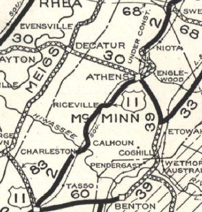
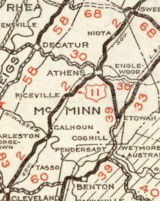
It is unclear when TN 2 was removed from Mabee Ave in Monteagle but my guess is the 1950s. About 1953, TN 2 was given its bypass of Athens. The old route through town became secondary for a number of years before becoming TN 2 Bus. Today it is TN 39, TN 305, and CR 379.
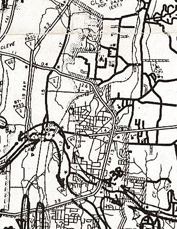
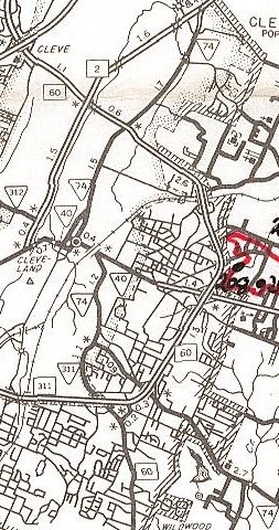
My guess is that TN 2 was removed from Glover Hill Rd in Jasper in 1954. In 1956 (bridge date), TN 2 was given one-way splits in Chattanooga. EB used 11th/Central/Bailey/Doods (replacing TN 2A #2) while WB used the original alignment of McCallie/Central/9th/Georgia (this became TN 2 Loop on the TN route log) About 1958, TN 2 was given its current route through Manchester. Originally it used Irwin/High/Spring/Fort/Woodland Sts. By 1961, the Chattanooga Splits were just Bailey EB and McCallie WB between Georgia and Dodds About 1962, TN 2 was placed on I-75 between exits 7 and 11 northeast of Chattanooga. This created a split routing with NB using Bonnie Oaks Dr to access I-75 NB, while SB still used Lee Hwy on the west side of I-75 which had a ramp from I-75 SB about 3/4 of a mile north of Exit 7. This left behind Old Lee Hwy on the east side of the interstate. Around 1964, TN 2 was removed from Dixie Lee Ave and a piece of Bluebird Ln south of Monteagle and placed onto I-24 EB lanes. I-24 EB was built more or less on top of TN 2 with just a few abandoned segments to smooth out some curves. At the bottom of the mountain, TN 2 was removed from Martin Springs Rd on the east side of I-24 to just south of the current TN 2 exit. In the 1960s, TN 2 was truncated to the current routing of US 70S/TN 1 south of downtown Murfreesboro. Around 1968, TN 2 was rerouted just west of the Tennessee River bridge Haletown to accommodate Nickajack Lake. Only a small bit of the original route within Marion County Park is not underwater. In 1983, TN 2 was rerouted around Cleveland, replacing TN 2 Byp. The old route through town became TN 40 south of downtown and TN 74 north of it.
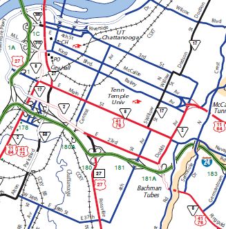
About 2004, TN 2 was removed from central Chattanooga entirely by using 20th/23rd/Dodds. The old routing into downtown remains part of US 72 and TN 8. Leaving downtown on its former one-way pairs is no longer in the state highway system.
Also about 2004, TN 2 was removed from Lee Hwy north of Exit 7 on I-75 as the far flung ramp was removed and new ramps were installed right at Exit 7. Posting: TN 2 is completely unposted, except for its solo section off I-24 near Kimball. The other solo segment between I-24 exit 135 and Monteagle is unposted. TN 2 is primary between I-75 Ooltewah and US 321 Lenoir City and secondary everywhere else. Secret US Route Overlay: US 41 (55.4 mi) US 64 (60.4 mi) US 11 (63.9 mi) Comment: TN 2 forms a V-shape with Chattanooga at the bottom point. It appears that TN 2 had a railroad underpass of under 8 feet in Ooltewah until it was relocated to I-75. | ||||||||||||||||||||||
Previous: TN 1 |
Next: TN 2A | TN 2 Bus | TN 2 Byp | TN 2 Loop | TN 2 Spur | TN 3
Top | Tennessee Hwy Index
Home
Page last modified 9 July 2023