< TN 1 | Home | TN 1A | TN 1 Byp | TN 1 Spur | TN 2 >
|
|
|
| ROUTE LOG |
I-55 SB (exit 12), US 61 NB, US 64 WB, US 70 WB, US 78 WB, US 79 WB: 0 - 0 US 61 SB, TN 14: 0.7 - 0.7 US 78 EB, TN 4 EB: 0.4 - 1.1 TN 278: 0.9 - 2.0 US 51 SB, US 64 EB, US 70 EB, US 79 EB, TN 3: 0.3 - 2.8 I-40 (exit 1): 0.8 - 3.6 US 51 NB, TN 4 WB: 0.3 - 3.9 US 64 WB, US 70 WB, US 79 WB, TN 57: 3.2 - 7.1 I-40 (exit 10): 5.4 - 12.5 US 64 EB, TN 15: 4.7 - 17.2 TN 177: 3.3 - 20.5 TN 385: 7.2 - 27.7 Fayette-Shelby Line: 3.6 - 31.3 TN 196: 1.7 - 33.0 TN 59 EB: 4.1 - 37.1 Tipton-Fayette Line: 2.1 - 39.2 TN 59 WB: 0.9 - 40.1 Haywood-Tipton Line: 3.9 - 44.0 TN 222: 4.2 - 48.2 TN 179: 0.1 - 48.3 TN 19 WB: 10.7 - 59.0 TN 76 SB: 2.2 - 61.2 TN 19 EB: 0.8 - 62.0 US 70 ALT, US 79 EB, TN 76 NB: 0.5 - 62.5 I-40 (exit 66): 8.2 - 70.7 Madison-Haywood Line: 1.2 - 71.9 TN 138: 1.1 - 73.0 TN 223: 8.2 - 81.2 US 45 Byp NB, TN 186 NB: 4.7 - 85.9 US 45, US 45 Byp END, TN 5, TN 186 END: 1.5 - 87.4 TN 198: 0.9 - 88.3 US 412 Bus WB, TN 20 WB: 2.8 - 91.1 US 412 EB, US 412 Bus END, TN 20 EB: 2.8 - 93.9 I-40 (exit 87), US 412 WB: 0.4 - 94.3 TN 152: 7.0 - 101.3 Carroll-Madison Line: 2.6 - 103.9 TN 104 SB: 3.5 - 107.4 TN 220: 0.4 - 107.8 TN 104 NB: 2.7 - 110.5 TN 424: 0.7 - 111.2 US 70 EB, US 70 Bus Begin, TN 22: 11.6 - 122.8 TN 22 Bus: 0.7 - 123.5 US 70 WB, US 70 ALT, US 70 Bus END, TN 364: 2.0 - 125.5 TN 219: 2.7 - 128.2 TN 114 SB: 4.4 - 132.6 TN 114 NB: 0.1 - 132.7 Benton-Carroll Line: 3.5 - 136.2 US 70 Bus, TN 391: 4.2 - 140.6 US 641, TN 69: 1.6 - 142.2 TN 191: 1.8 - 144.0 US 70 Bus, TN 391: 0.9 - 144.9 Humphries-Benton Line: 4.3 - 149.2 TN 13 Spur: 13.2 - 162.4 TN 231: 9.2 - 171.6 Dickson-Humphries Line: 5.1 - 176.7 TN 46 NB, TN 235 NB: 8.1 - 184.8 US 70 Bus, TN 235 SB: 0.1 - 184.9 TN 48: 1.1 - 186.0 TN 46 SB: 0.5 - 186.5 US 70 Bus, TN 235: 0.4 - 186.9 TN 96: 1.6 - 188.5 TN 47 SB: 6.3 - 194.8 TN 47 NB: 0.6 - 195.4 Davidson-Dickson Line: 3.2 - 198.6 TN 249 SB: 7.2 - 205.8 TN 249 NB: 0.2 - 206.0 US 70 EB, US 70S Begin, TN 24: 5.5 - 211.5 I-40 (exit 196): 1.8 - 213.3 TN 251: 2.1 - 215.4 TN 100: 3.3 - 218.7 TN 155: 2.2 - 220.9 I-440 (exit 1): 1.7 - 222.6 US 431 SB, TN 106: 2.0 - 224.6 I-40 (exit 209), I-65, US 70 WB, TN 24 WB: 0.2 - 224.8 US 31 NB, US 41 NB, US 41 ALT NB, US 70 EB, US 431 NB, TN 6 NB, TN 11 NB, TN 24 EB: 0.5 - 225.3 US 31 SB, US 31 ALT Begin, TN 6 SB: 0.3 - 225.6 US 31 ALT SB, US 41 ALT SB, TN 11 SB: 0.6 - 226.2 I-24 (exit 52): 2.6 - 228.8 TN 155: 2.0 - 230.8 TN 255: 1.7 - 232.5 TN 254: 3.2 - 235.7 TN 171: 2.6 - 238.3 Rutherford-Davidson Line: 1.8 - 240.1 TN 266: 3.7 - 243.8 TN 102: 3.3 - 277.1 I-840 (exit 55): 4.6 - 281.7 TN 268: 2.3 - 284.0 US 231 NB, TN 10 NB, TN 96, TN 99 WB: 2.4 - 286.4 US 231 SB, TN 10 SB: 0.7 - 287.1 US 41 SB, TN 2, TN 99 EB: 0.5 - 287.6 Cannon-Rutherford Line: 12.0 - 299.6 TN 64: 1.6 - 301.2 TN 145: 4.3 - 305.5 TN 53 SB: 0.7 - 306.2 TN 53 NB: 0.7 - 306.9 TN 281: 5.1 - 312.0 TN 146: 1.6 - 313.6 Warren-Cannon Line: 0.8 - 314.4 TN 287 SB: 3.4 - 317.8 TN 287 NB: 0.1 - 317.9 TN 55, TN 380: 7.1 - 325.0 TN 56: 1.3 - 326.3 TN 380: 2.1 - 328.4 TN 30: 2.9 - 331.3 TN 288: 0.8 - 332.1 Van Buren-Warren Line: 6.6 - 338.7 White-Van Buren Line: 2.9 - 341.6 TN 285: 4.8 - 346.4 TN 111 SB: 2.8 - 349.2 US 70S EB, TN 111 NB: 3.1 - 352.3 US 70 WB, TN 26: 1.0 - 353.3 TN 289: 0.1 - 353.4 TN 84: 0.7 - 354.1 Cumberland-White Line: 12.6 - 366.7 TN 462: 11.3 - 378.0 US 70N, TN 24: 2.0 - 380.0 TN 392: 0.4 - 380.4 TN 101 SB: 1.0 - 381.4 US 127, TN 28: 0.1 - 381.5 TN 101 NB: 2.4 - 383.9 TN 299: 16.5 - 400.4 Roane-Cumberland Line: 0.5 - 400.9 US 27 SB, TN 29 SB: 2.8 - 403.7 US 27 NB, TN 61: 2.8 - 406.5 TN 382: 3.2 - 409.7 TN 29 NB: 4.9 - 414.6 TN 58: 2.8 - 417.4 TN 326: 3.8 - 421.2 US 321, TN 95: 10.7 - 431.9 US 11 SB, TN 2: 4.4 - 436.3 Knox-Roane Line: 0.2 - 436.5 TN 332: 4.0 - 440.5 TN 131: 1.6 - 442.1 I-140 (exit 1), TN 162: 1.2 - 443.3 TN 332: 7.0 - 450.3 US 129, TN 115: 3.7 - 454.0 TN 450: 0.2 - 454.2 TN 158: 2.5 - 456.7 US 11 END, US 11E, US 11W Begin, US 70 EB, TN 168: 3.7 - 460.4 I-40 (exit 392): 0.4 - 460.8 Grainger-Knox Line: 12.6 - 473.4 TN 61: 1.8 - 475.2 TN 92: 14.0 - 489.2 US 25E NB, TN 32 NB: 11.4 - 500.6 US 25E SB, TN 32 SB: 2.7 - 503.3 Hawkins-Grainger Line: 1.4 - 504.7 TN 31: 2.0 - 506.7 TN 344: 10.2 - 516.9 TN 66, TN 70 SB: 3.1 - 520.0 TN 70 NB, TN 347: 2.7 - 522.7 TN 346: 5.4 - 528.1 TN 346 SB: 6.6 - 534.7 TN 346 NB: 4.6 - 539.3 Sullivan-Hawkins Line: 6.5 - 545.8 I-26 (exit 1), US 23: 1.9 - 547.7 TN 36: 0.8 - 548.5 TN 93: 3.5 - 552.0 TN 394: 9.3 - 561.3 I-81 (exit 74): 5.7 - 567.0 TN 126: 2.2 - 569.2 US 11W NB, US 421: 0.6 - 569.8 US 11E NB, US 19 NB, US 421 NB, VA 381: 1.2 - 571.0 US 11E SB, US 19 SB, US 421 SB, TN 34: 0.2 - 571.2
|
Creation: Appeared in 1923 as an original state highway, running generally the way it does now. TN 1 was assigned to the Memphis-Bristol Hwy, the first state maintained highway in Tennessee (since 1911).
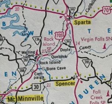
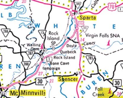
| 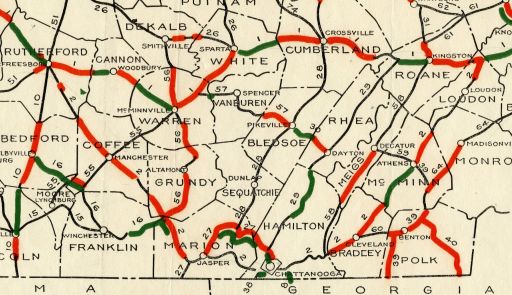 TN 2 is a giant V 1926 Official Adjustments: About 1924 (bridge dates), TN 1 was removed from abandoned routing near the Madison-Carroll Line; Daniel Rd; abandoned routing; Boyd Ln/Wood Hill Rd/Aldridge Ln; abandoned routing; Wood Creamery Ln. It is possible TN 1 was also removed from more abandoned routing across Middle Fork Deer River; Providence Cemetery Rd/Terry Rd to Terry, then Old Stage Rd. Bridges closer to Huntingdon were not built until 1928, so TN 1 may have moved to to the modern routing and temporarily put on Ledsinger Rd to Old Stage Rd above Terry. About 1925, TN 1 was placed on Main St east out Waverly. The old route was TN 13 Church St, N Church St, what is now US 70, S. Railroad St, abandoned routing across US 70 and the RR, E. Railroad St all the way back to US 70. By 1926, TN 1 was removed from Old Stage Rd east of TN 2 Dixie Lee Jct. TN 1 used today's US 11 between old and new alignments. About 1926, TN 1 was placed on its current alignment from Galloway to Brownsville. The old route used Old Brownsville Rd/TN 196 through Galloway; Burrowtown Rd/Witherington Rd/Beaver Creek Rd to Braden; current TN 1; Front St to Mason, which used to connect to Washington Ave; Old L and N Rd/Keeling Rd east; TN 222 north to Stanton; 2nd/Main St through Stanton; TN 179 to near Asbury; Stanton-Koko Rd to Willis; TN 76 to Brownsville (except TN 1 used the segment of Hatchie St between TN 76 and US 70-79 plus all the way to the town square). Also about 1926, TN 1 was straightened out in western Madison County, leaving behind abandoned alignments clearly visible on 1947 aerials. Also about 1926, TN 1 was straightened out in the Spring Creek area removing it from western abandoned routing from south of Waynick Rd, across Ashport Rd, using some of Key Senter Rd, across Grimes Creek and Mt Carmel Church Rd, crossing US 70 to use Doak Mason Rd In Dec 1926, US 70 was added to TN 1 from Arkansas to Nashville; US 270 from Nashville to Sparta; US 70 from Sparta to Knoxville; US 11 from Knoxville to Virginia. By 1927, TN 1 was removed from Lawndale Rd east of Kingston to Lawndale; Kidwell Ln (no longer connects to)/S Cripple Creek Rd/Ladd Ridge Rd About 1928 (bridge dates), TN 1 was straightehed out northeast out Jackson, leaving behind to the east from about Lawrence Switch Rd to Watson Rd; a bit of Watson Rd; abandoned routing halfway to US 412 Bus; abandoned routing to the west from New Deal Rd to a little south of Spain Rd About 1928, TN 1 was removed from Ledsinger Rd and Old Stage Rd from above Terry to nearly Huntingdon. This may have been when TN 1 was removed from the old routing south of Terry described earlier that could have been bypassed in 1924. If TN 1 ever used Kingston Springs Rd/today's TN 249 through Kingston Springs, it stopped doing so by 1929. By 1929, TN 1 was rerouted in the Rock Island area: removed from abandoned routing starting a bit north of the US 70S-TN 136 jct; part of Miller Ln which no longer connects to Bess Ln; Old Kentucky Ln which no longer connects to Old Ferry Rd to Rock Island; today's TN 287; Great Falls Dam; Great Falls Rd/River Rd/Power House Rd; Holder Station Rd out of Quebeck (no longer connects to)/Armstrong Rd (no longer connects to) Papermill Rd/Garrett Rd; Old Stage Coach Rd; Hodges Bridge Rd; unclear routing; Jolley Rd; County House Rd By 1929, TN 1 was given its current route from Crossville to Crab Orchard. The old route used 1st St/Chestnut Hill Rd (except Blevin Rd in Dorton), Gate Rd, Eroh Rd until it reaches I-40; abandoned routing that is largely occupied by I-40 that crossed Daddy Creek at the WB rest area; the part of Main St south of I-40 that is not parallel to it; Pea Ridge Rd/Main St into Crab Orchard About 1929, TN 1 was placed on its current alignment out of Memphis to Galloway. The old route used today's 2nd St north to Willis Ave east which used to transition to Jackson Ave (configuration at US 51 is different now); TN 14 to TN 15, except TN 1 used Old Austin Peay Hwy; TN 15 to Bartlett; Sycamore View Rd north to Memphis-Arlington Rd east; at about Kirby-Whitten Pkwy, the road used to head due east to connect to a cutoff segment of Memphis-Arlington Rd; Oak St north to Memphis-Arlington Rd east to Arlington (including TN 177 dogleg); Douglass St, Polk St, Walker St, Chester St through Arlington; TN 205 north then Galloway Levee Rd to current TN 1 Galloway.
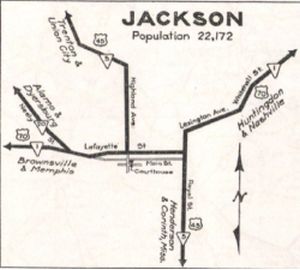
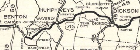
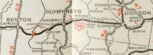
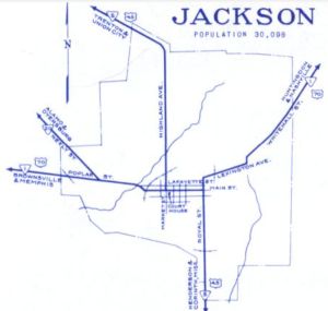
Between 1925-30, TN 1 was removed from Old Blacktop Rd and Long St into McEwen. TN 1's original route leaving Jackson appears to have been Main/Hays/Preston/Springcreek (now Whitehall). By 1930, it changed to Main/Royal/Lexington/Elizabeth/Whitehall By 1930, TN 1 was removed from Old Bon Air Rd near Bon Air (no longer connects to)/Lake Rd (no longer connects to)/lovejoy Rd (no longer connects to)/Broom Rd/Eastland Rd to De Rossett; W and E Ravenscroft Rd through Ravenscroft Also by 1930, TN 1 was removed from Bluff Rd and Old Rockwood Hwy between the Midtown area and the original Clinch River bridge to Kingston; also Lawndale Rd to Lawndale; Kidwell Ln (no longer connects to)/S Cripple Creek Rd/Ladd Ridge Rd Also about 1930, TN 1 was removed from Old Rutledge Pike in Knox County southwest of Blaine In 1930 or 1931, TN 1 was given a direct route between McEwen and Dickson. The original route was Long St/Railroad St N/Melrose St in McEwen; Old Nashville Hwy/Old Number 1; today's TN 46 to Dickson Also about 1931, TN 1 was removed from Manor Lodge Rd/Trotters Landing/Crockett Landing Rd; ferry across the Tennessee River; Old State Road 1 through Hustburg and Plant; Bakerville Rd to Waverly Also about 1931, TN 1 was given its current routing between Ozone and US 27 south of Rockwood. The old route used Ozone Rd through Daysville; Pig Path Rd (no longer connects to)/Mt. Vernal Rd to Mt. Vernon; Westal Rd until it parallels I-40; abandoned routing south of I-40; Westal Rd where it leaves I-40 to cross TN 299; Airport Rd/Furnace Ave/Rockwood St to Rockwood In 1931 or 1932, TN 1 was rerouted in Nashville. It originally ran Lafayette/2nd/Peabody/4th/Broadway/8th/Church/West End. Now it ran Lafayette/2nd/Broadway/6th/Union/8th/Church/West End. In 1931 or 1932, TN 1 was removed from Smith Valley Rd (no longer connects to)/Old Stage Rd west of US 11. By 1932, TN 1 was removed from Old Harding Pike near Belle Meade In 1935, TN 1 was rerouted in Nashville to use Lafayette/2nd/Peabody/1st/Broadway/West End. If TN 1 ever used Carters Chapel Rd between the Roane/Loudon line and Eaton Crossroads it stopped doimg so by 1935. By 1935, TN 1 was removed from Hornberg Dr (no longer connects to)/Old Kingston Pike in Knoxville. Between 1931-36, TN 1 was removed from Ferguson Dr/underwater routing/original Clinch River bridge/Mill St/Spring St in Kingston; Old Race St By 1936, TN 1 was removed from Missioary Grove Church/Coleman Rd in Morris Chapel. Also by 1936, TN 1 was removed from Loves Creek Rd/Parker Dr just east of I-640. In 1936 (bridge date), TN 1 was removed from Old Rutledge Pike/Indian Ridge Rd/Maple Dr through Blaine; Geer Ln near Lea Springs In 1936 or 1937, TN 1's routing in Jackson changed from Lexington/Elizabeth/Whitehall to Lexington/Whitehall
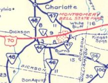
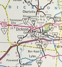
By 1938, TN 1 was removed from Oak Grove Rd/Old Denmark Rd at Westover west of Jackson In 1938, TN 1 was removed from Northwood Dr between Huntingdon and Rosser; Kee St in Hollow Rock By 1939, TN 1 was removed from Old McMinnville Rd/abandoned routing east of Woodbury; also Bridge Builders Rd near McMinnville Also by 1939, TN 1 was removed from Brookmont Terrace in Belle Meade Also by 1939, TN 1 was removed from Old Hwy Rd in De Rossett Also by 1939, TN 1 was removed from Arthur Seagraves Rd/Glade Creek Rd at Smith Chapel About 1940, TN 1 was removed from Blaines Chapel Rd at Joppa; Bryan Rd outside Rutledge; Clifford Price Loop well east of Mooresburg About 1941, TN 1 was given a direct route from Dickson through White Bluff. The old route became TN 46 from Dickson to Burns (now US 70 Bus/TN 46/TN 47); TN 47 from Burns to White Bluff; Church St through White Bluff.
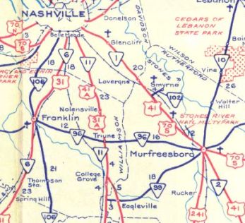
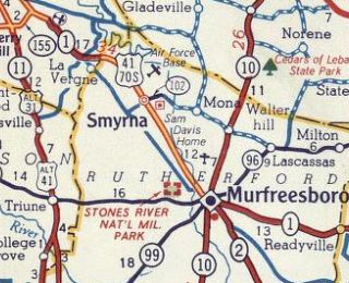
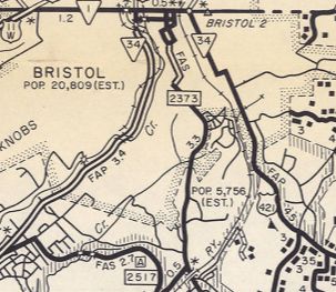
Also about 1941, TN 1 was removed from the 4 Old US 70 loops east of White Bluff In the 1940s, TN 1 was removed from Post Rd/Old Post Rd/Commodore Dr and South Cir west out of McMinnville. Also in the 1940s, TN 1 was removed from Old Lee Hwy in the post lake location of Bean Station Around 1942 or so, TN 1 was rerouted around the north of Cherokee Lake. This reoved the route from Grace Church Rd; 6+ miles of underwater routing; abandoned routing west of US 11W-25E jct with Main St. Also around 1942, TN 1 was rerouted to avoid the expanded Holston River east of Mooresburg. This reoved the route from Substation Rd/almost 2 miles of underwater routing/part of Lakemont Rd/3/4 mile underwater routing. Between 1939-46, TN 1 was removed from Bristol Hwy (now Center St) in Kingsport and placed on todays Fort Henry Dr/Memorial Ct/Memorial Blvd Between 1943-47, TN 1 moved from 2nd St to 3rd St in Downtown Memphis. In 1947, TN 1 was removed from Old US 70 just southeast of Camden; Old Route One southeast of Morris Chapel. Between 1944-48, TN 1 was rerouted in Nashville to use Lafayette/8th/Broadway/West End. In 1949, TN 1 was placed on the new Memphis-Arkansas bridge, leaving behind the Hanaran Bridge which is still open to foot/bicycle traffic. About 1950, TN 1 was removed from Grooms Rd east of Rosser; Park Ln in Hollow Rock; Old Bruceton Rd and Selber Ln east of Bruceton Between 1941-51, TN 1 was moved from Lafayette to Main through central Jackson. In May 1952 (CTB), TN 1 was rerouted in Bristol to be on one-way splits. westbound along State St was not changed. Eastbound used State St east to 9th St (now Volunteer Pkwy), then south to Shelby St east to 7th St where TN 1 ended at TN 34. In 1953, TN 1 was removed from Kingston Ave/Molyneux St/Kingston Ave through Rockwood; Old kingston Hwy and Old Hwy 70/Post Oak Valley Rd esat of Rockwood; Headwaters Dr/Poland Hollow Rd at the Caney Creek Marina area; Old Hwy 70/Old Midtown Hwy/Keylon Dr/Old Rockwood Hwy west of the Clinch River Kingston; Cumberland St and Kentucky St within Kingston About 1953, TN 1 was removed from W. College St out of Murfreesboro and the lengthy Old Nashville Hwy to La Vergne. TN 1 used part of today's Goodman Cir.
Also about 1953 (bridge dates), TN 1 was removed from Cherry St/Old US 11W out of Rutledge; Old US 11W at Bowen Between 1948-56, TN 1 was removed from J Bond Ln east of TN 138; also removed from the westernmost 0.2 miles of Wellwood Rd alongside I-40 west of Huntersville Between 1952-55, TN 1 was removed from Main St through Pleasant Hill Between 1952-55, TN 1 was removed from Lockett Rd/Deane Hill Dr in Knoxville; also Newton Ave/Forest Park Blvd/Old Kingston Pike in Knoxville Between 1952-56, TN 1 was put on one-way routing through downtown Memphis, with EB using 3rd and WB using 2nd/Calhoun. Also between 1952-56, TN 1 was removed from Frye Access Rd near Cedar Grove; Sanders Loop and Tate Loop near Tate; In the mid 1950s, TN 1 was rerouted in Murfreesboro. Originally it used College/Spring/Main. Now, TN 1 used Broad/Dr King/Lasseter/Main
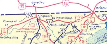
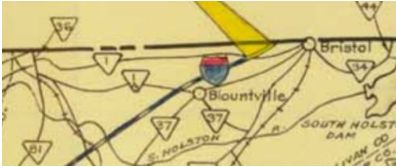
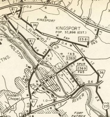
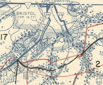
About 1956, TN 1 was removed from Holston Dr and ML King Ave (no longer connects to)/McCallie Ave in eastern Knoxville Between 1956-58, TN 1 was removed from an abandoned loop in far eastern White County; Old State Hwy 1 in western Cumberland County; Old State Rd in Smiths Chapel About 1958 (bridge date), TN 1 was removed from Old Highway 70 frok Claysville through Pomona to nearly Crossville. About 1959 (bridge date), TN 1 was removed from Sparta Dr in Crossville Also about 1959, TN 1 was given its current routing between Kingsport and Bristol. TN 1 was placed on TN 81A (Sullivan St) and US 23(Lynn Garden Dr) temporarily connecting TN 1 from Netherland Inn Dr and the new four lane TN 1. The old route may have briefly been renumbered as TN 1A but today is TN 355 Center St; TN 36 Center St; TN 126 from Kingsport to Bristol except: Memorial Ct in Kingston, TN 126 Bus in Blountville, and a bit of Stafford St at Bristol.
Between 1957-60, TN 1 was removed from more Wellwood Rd to accomodate I-40; also removed from Technology Center Dr/ (no longer connects to) Westover Rd west of Jackson In 1962, TN 1 was removed from Netherland Inn Rd and the temporary connection to the Kingston Bypass via then-TN 81A and US 23.
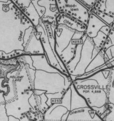
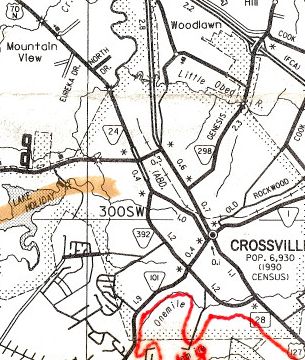
Between 1960-64, TN 1 was removed from Old Murfreesboro Rd in Una. Between 1959-67, TN 1 was removed from Gaines St/Country Club Rd east out of Sparta, plus the Old US 70 loop at the east end of that By 1967, TN 1 was given one-way splis in McMinnville. EB used the original routing of Main/Sparta, while WB used Morford. About 1967, TN 1 was removed from Main St through Rogersville. About 1968, TN 1 west was truncated to the I-55/Crump Blvd interchange, leaving behind I-55 and US 61-63-64-70-79. Between 1965-69, TN 34 was moved to Volunteer Pkwy and TN 1 east was truncated from 4th/5th to there. In 1969, TN 1 was removed from Hollister Mills Rd; Main Blvd through Church Hill; Main St through Mount Carmel Between 1968-74, TN 1 was rerouted in Crossville from West/5th/Main/Lantana to just West/Lantana. Main St remains part of US 127.
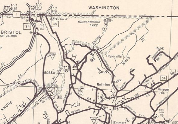
By the early 1970s, TN 34 was removed from State St between Volunteer Pkwy and MLK Jr Blvd. Instead it left Volunteer Pkwy at Anderson to reach MLK Jr Blvd north back to State St. TN 1 was extended south on Volunteer Pkwy to TN 34 on Anderson.
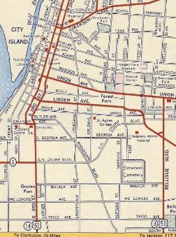
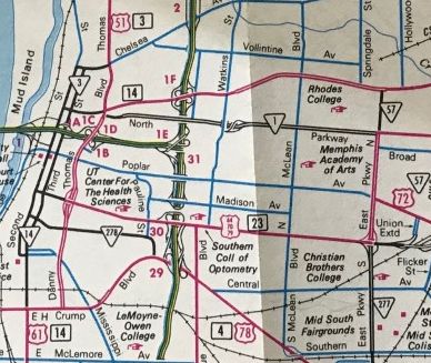
Around the mid-1970s, TN 1 was straightened out in eastern Cannon County leaving behind several abandoned alignments, plus Elkins Cir and Lincoln Ln In 1976 (bridge dates), TN 1 was removed from Old Rutledge Pike through John Sevier; Old Rutledge Pike near Three Points About 1977, TN 1 was removed from Main St/Windy Hill east of TN 347; Old Hwy Rd; Sizemore Ln/Carter Valley Loop/Clyde Rd; Bloomer Ln/today's TN 346 through Surgoinsville; Burlington Rd east of Surgoinsville About 1983, TN 1 was rerouted in Memphis using North Parkway west to Danny Thomas then south to Crump. The old routing on East Pkwy remained US 64-70-79; Union west of Danny Thomas became TN 3; 2nd/3rd remained TN 14.
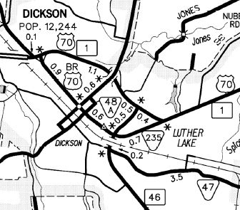
Also about 1983, TN 1 replaced TN 1 Byp around Dickson, leaving behind TN 235
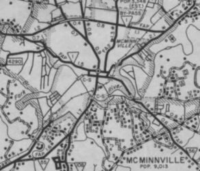
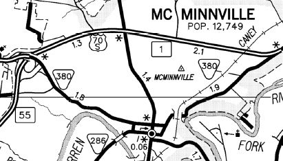
Also about 1983, TN 1 replaced TN 1 Byp around McMinnville, leaving behind TN 380
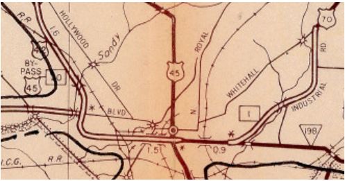
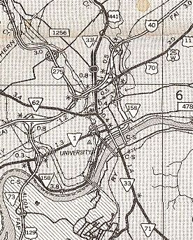
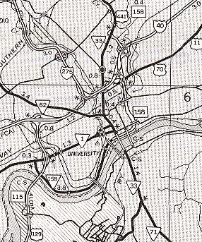
About 1984, TN 1 was reoved from Un Access Rd (no longer connects to)/Loretta Ln near Mooresburg; Old Hwy 11W/Martin Ln through Mooresburg; Gills Chapel Church Rd/Old US 11W/Marble Hall Rd and Carpenter Cir west of Rogersville Between 1981-85, TN 1 was placed on one-way splis in central Knoxville - EB used the original Main St routing and WB used Cumberland. Between 1982-85, TN 1 was given its current routing through Jackson via Chester St. Airways/Main/Royal/Lexington/Elizabeth/Whitehall was removed from the state highway system.
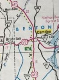
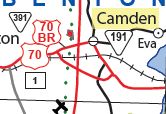
About 1986, TN 1 was placed on the new southern bypass of Camden, leaving behind TN 391.
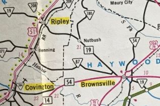
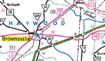
About 1989, TN 1 was removed from Main St through Waverly. A bit of this became TN 13 Spur. Also about 1989, TN 1 was removed from Old Rock Island Rd between McMinnville and Campaign. The southern bit of this became part of TN 288. Between 1990-92, TN 1 was removed from Old Woodbury Pike through Readyville and Murfressboro Rd through Woodbury. In 1993, TN 1 was removed from Ruritan Rd/Calvary Church Rd near Mooresburg In 1995, TN 1 was placed on its bypass around the south and east of Brownsville, leaving behind Grand Ave; TN 54 on Main St west of the square; Main St east of the square
Also about 1995, TN 1 was removed from Lasseter/Main from Murfreesboro through Kittrel. Also about 1995, TN 1 was removed from C O Hines Rd near Campaign; Rock Island Rd through Rock Island (became TN 136; McMinnville Hwy through Welling and Doyle. TN 1 used TN 111 to get back to Maybury St in Sparta.
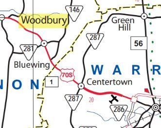
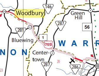
About 1998, TN 1 was removed from Main St through the post lake location of Bean Station In 2007, TN 1 was changed to leave Broadway at 5th instead of Magnolia in Knoxville. About 2013, TN 1 was removed from Old Nashville Hwy/(no longer connects to) Airport Rd east of Centertown to nearly McMinnville. TN 1 temporarily used TN 287 to get between old and new alignments. In 2014, TN 1 was rerouted over TN 158 on Neyland Dr, then used Hall of Fame Dr to get back to Magnolia in Knoxville.
About 2015, TN 1 was reoved from McMinnville Hwy and Old Nashville Hwy west of Centertown.
Posting: TN 1 is completely unposted, except for its solo sections in Memphis and Sparta. The solo Bristol segment is unposted. TN 1 is primary everywhere except it is secondary on its Memphis solo segment; Brownsville to Jackson; US 70/TN 24 to TN 100; Crossville to Knoxville. Secret US Route Overlay: US 70 I (2.8 mi) US 51 (1.1 mi) US 70 II (119.0 mi) US 70 Bus (2.7 mi) US 70 III (86.0 mi) US 70S (140.8 mi) US 70 IV (107.1 mi) US 11W (109.4 mi) US 11E (0.2 mi) Comment: TN 1 is by far the longest highway in Tennessee. I always wondered why TN 1 didn't extend to North Carolina via Mountain City... | |||||||||||||||||||||||||||||||||||||||||||||||||

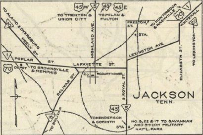
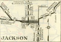
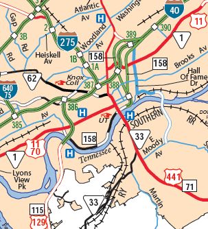
 TN 1 using Main to Magnolia
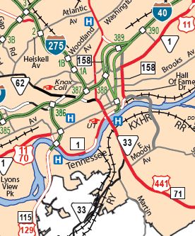
 TN 1 on Main/Cumberland splits
Previous: TN 840 |
Next: TN 1A | TN 1 Byp | TN 1 Spur | TN 2
Top | Tennessee Hwy Index
Home
Page last modified 9 July 2023