< US 321 | Home | US 412 >
|
|
|
| ROUTE LOG |
GA STATE LINE: 0 - 0 TN 313: 3.1 - 3.1 US 64, US 74, TN 40: 6.7 - 9.8 TN 314: 5.8 - 15.6 TN 30 EB: 6.0 - 21.6 TN 163: 1.9 - 23.5 McMinn-Polk Line: 0.7 - 24.2 TN 310: 4.6 - 28.8 TN 30 WB: 0.8 - 29.6 TN 39 WB: 6.3 - 35.9 TN 39 EB: 0.2 - 36.1 Monroe-McMinn Line: 3.0 - 39.1 TN 68: 5.5 - 44.6 TN 72 WB: 7.4 - 52.0 TN 360: 2.4 - 54.4 TN 72 EB: 2.7 - 57.1 Loudon-Monroe Line: 0.1 - 57.2 TN 95: 3.2 - 60.4 Blount-Loudon Line: 0.8 - 61.2 TN 336: 1.7 - 62.9 US 129 SB, TN 115 SB: 4.4 - 67.3 TN 335: 1.8 - 69.1 US 129 NB, TN 115 NB: 2.5 - 71.6 US 321, TN 73: 1.1 - 72.7 TN 33 NB, TN 35 WB: 0.8 - 73.5 TN 447: 0.2 - 73.7 Sevier-Blount Line: 13.1 - 86.8 US 441 NB, TN 71 NB, TN 338: 1.7 - 88.5 US 441 SB, TN 71 SB, TN 66: 12.5 - 101.0 TN 448: 0.3 - 101.3 TN 449: 1.1 - 102.4 TN 416: 2.0 - 104.4 TN 339: 0.9 - 105.3 Jefferson-Sevier Line: 9.3 - 114.6 TN 92: 1.1 - 115.7 Cocke-Jefferson Line: 4.0 - 119.7 US 25W NB, US 70 WB, TN 35 END, TN 9 NB: 1.0 - 120.7
|
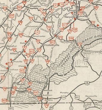
Creation: Approved by AASHO in late 1934 to run from Conasauga to Bristol, US 411 first appeared on Tennessee official maps in 1940 as the 3rd US 411 nationally (and second iteration to make it to Tennessee), running from the Georgia line at Conasauga to Maryville. This was an addition to TN 33. Note that at least one prominent commercial mapmaker showed this, which was part of AASHO's effort to get rid of US 11E.
| 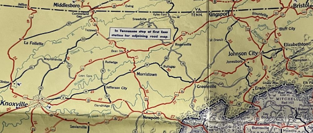 AASHO's dream come true - no US 11E 1935 Gen Draft Adjustments: Between 1940-43, US 411 was removed from Old Englewood-Etowah Rd Between 1944-46, US 411 was shown on Tennessee Officials to have been extended north with TN 35 to US 11E (now US 11E Bus) Greeneville.
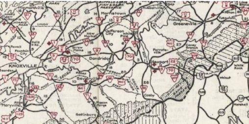
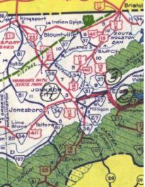
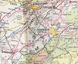
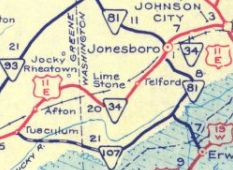
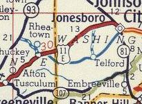
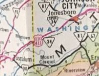
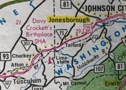
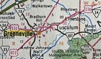
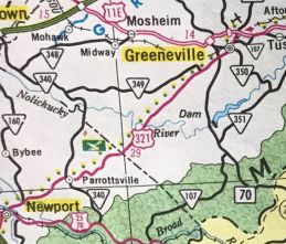
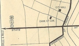
In 1946, US 411 was removed from Mull Rd and Barton Station Rd west of Benton In 1952, noting that signage was already on the ground, US 411 was extended officially north to Bristol. In 1952, US 411 was removed from the lengthy Heritage Rd/Old SR 34/present TN 353 through Limestone and Telford to Jonesborough. US 411 entered Jonesborough via Persimmon Ridge Rd. Also in 1952, US 411 was put on one-way splits in Bristol using 4th St NB (now Dr. Martin Luther King Jr Dr) and 5th St SB. In 1959, US 411 was put on the Jonesborough bypass, leaving behind TN 34 Spur, a little TN 81 and Boone St In 1963, US 411 was placed on its current route through Sevierville and east to nearly Birds Crossroad. The old routing used Parkway, Park Rd, Eastgate Rd (no longer connects to)/Old Newport Hwy (no longer connects to)/TN 416, another long Old Newport Hwy (partly uses today's TN 339) About 1965, US 411 was extended through Greeneville replacing TN 93 out to the new US 11E bypass. In 1967, US 411 was removed from Old Newport Hwy through Caney Branch and (no longer connects to) Fallen Bridge Rd at the Nolichucky River crossing. In 1967, US 411 north was truncated to the US 19E-19W split (now TN 44 at Elizabethton Hwy) in Hillcrest. The route to Bristol remains US 11E-19. It is unclear if US 411 underwent this change in Bristol prior to truncation: moved to the Bristol Bypass and a one-way pair using State St WB and Shelby St/4th St EB, replacing TN 34 Byp. The old route used Bluff City Hwy, Edgemont Ave, Dr. Martin Luther King Jr Dr, Alabama Ave (no longer connects to), one way pair of 4th (now part of MLK Jr Dr)/5th Ave In 1975, US 411 was placed on the new Madisonville bypass. The old route used Englewood Rd/College St/Warren Rd Also in 1975, US 411 was removed from a bit of Rock Hill Rd, removed bridge over French Broad River and Old Greeneville Hwy. In 1976, US 411 north was truncated to Greeneville, leaving behind US 11E. It is still US 11E except: old TN 44 and TN 44 to Hillcrest and Bluff City; TN 390 and abandoned routing around the TN 394 interchange north of Bluff City; TN 91 into central Johnson City and Roan St north out of downtown.
In 1980, US 411 was removed from Chuckey Hwy in far eastern Greene County.
In 1984, US 411 north was truncated to Newport, leaving behind US 321 which had been recently added to the route to Greeneville. It remains US 321 except: Old Parrottsville Hwy west through Parrottsville, Sable Rd (no longer connects to)/Carter Valley Rd;
About 2012, US 411 was removed from Old Hwy 411 south of Benton. In 2015 or 2016, US 411 was removed from a lengthy Old Hwy 411 from US 25W-70 westward. This shifted the north end of US 411 slightly westward on US 25W-70. Posting: Fully posted Secret TN Route Overlay: TN 33 (73.5 mi) TN 35 (47.2 mi) Comment: US 411 is the easternmost N-S corridor in southeastern Tennessee US 411 has had a really confusing history. | Previous US 411's:
|
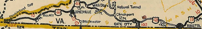
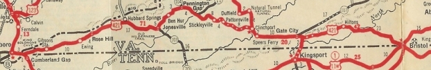
US 411 #1: An original US highway that ran from US 25E Cumberland Gap to Bristol, all within Virginia, except it is shown to have been posted into central Bristol and therefore ran on State St. This means that EB US 411 was in Tennessee.
In 1932, US 411 was renumbered as part of US 421.
| ||||||||||||||||||
Previous: US 321 |
Next: US 412
Top | Tennessee Hwy Index
Home
Page last modified 13 Febuary 2021