ROUTE LOG
DC LINE: 0 - 0
EXIT 177 (old 1) - US 1: 1.07 - 1.07
Fairfax-Alexandria Line: 0.25 - 1.32
EXIT 176 (old 2) - VA 241: 1.26 - 2.58
EXIT 174 (old 3A) - Eisenhower Ave. Connector: 1.55 - 4.13
EXIT 172 (old 3) - SR 613: 1.54 - 5.67
EXIT 57/170 (old 4) - I-95 SB, I-395: 1.94 - 7.63
EXIT 54 (old 5) - SR 620: 3.34 - 10.97
EXIT 52 (old 6) - VA 236: 1.83 - 12.80
EXIT 51 (old 7) - SR 650: 1.35 - 14.15
EXIT 50 (old 8) - US 50: 1.34 - 15.49
EXIT 49 (old 9) - I-66 (exit 64): 0.76 - 16.25
EXIT 47 (old 10) - VA 7: 2.33 - 18.58
EXIT 46 (old 11) - VA 123: 0.42 - 19.00
EXIT 45 (old 12) - VA 267: 0.92 - 19.92
EXIT 44 (old 13) - VA 193: 1.60 - 21.52
EXIT 43 (old 14) - George Washington Pkwy: 0.98 - 22.50
MD STATE LINE: 0.49 - 22.99
|
|
Creation: The current Washington Beltway shows up on planning documents as early as 1951. The I-495 designation was definitely in place by 1960 and may have been in place as early as late 1958. In April 1958 this had been proposed by Virginia to be I-68. The beltway was also referred to in numerous CTB references and is on at least 1 Fairfax County planning map as VA 413. Note that the 1957 Route Log assigns VA 88 to the Washington Circumferential Highway.
The first official to show it is the 1961 official. Per Scott Kozel's website, the first segment to open was from VA 350 (now I-95/395) west to US 50, in Dec 1961.
Adjustments: In late Dec 1961 (Kozel), I-495 opened from US 1 across the original Woodrow Wilson Bridge.
In Dec 1962 (Kozel), I-495 opened from the American Legion Bridge south to VA 7.
In Oct 1963 (Kozel), I-495 opened from VA 7 to US 50.
In April 1964 (Kozel), I-495 opened from VA 350 east to US 1, completing I-495 in Virginia.
In Oct 1975 (CTB), I-495 from Springfield to the Woodrow Wilson Bridge was renumbered as part of I-95.
In Aug 1991 (CTB), I-495 was re-extended as a concurrence with I-95 back over to the Wilson Bridge.
Improvements: upon designation I-495 was 4-lanes from I-95 west and north to the American Legion Bridge and 6-lanes from I-95 east to the Wilson Bridge.
In 1977 (Kozel), I-495 was widened to 8-lanes from VA 193 south and east to US 1 Alexandria.
In 1992 (Kozel), I-495 was widened to 8-lanes from VA 193 northward to Maryland.
In 1998, the only new interchange on the Virginia side of the Beltway was opened - the Eisenhower Ave Connector in Alexandria.
In July 2007, the Springfield Interchange with I-95/395 was completely redone after an 8-year project. This is the 3rd different configuration of this interchange, often incorrectly referred to as the "Mixing Bowl"
|
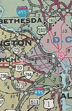
I-495 surrounds Washington DC
1965 Official
|
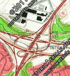
Original Springfield Interchange layout
1966 Topo
|
Second Springfield Interchange layout
1994 Topo
|
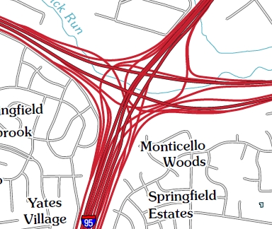
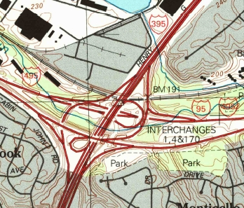
Current Springfield Interchange layout
2010 Topo
|
In Dec 2008, I-95/495 was widened to 10 lanes from west of VA 241 to across the Potomac River, by introducing a separated 2-lane roadway in each direction that serves as "Thru" lanes, while 3 "Local" lanes to the outside also exist. All lanes are able to be used for through traffic - the EB Thru lanes have no exits in Virginia but can be accessed from US 1 and from Eisenhower Ave (via Mill Rd) and the WB Thru lanes have an exit for Eisenhower Ave via Mill Rd and can be accessed from US 1. Froggie has some photos of this area at this link.
In late 2012, I-495 was given 2 HOoT lanes in each direction from south of SR 620 Braddock Rd to just north of VA 267 Dulles Toll Road. This was mostly done by widening each direction by two lanes rightward and converting the two inner lanes to the Express Lanes.
In November 2025, the Express lanes were extended north to the George Washington Parkway.
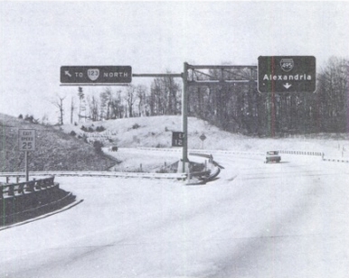
Here is a breakdown of how the exits of the Beltway were initially configured/posted. These come from "Highway Safety, Design, and Operations - Freeway Signing and Geometrics" which is a transcript of Hearings before the Special Subcommittee on the Federal Aid Highway Program in the House of Representatives, conducted in May and July 1969.
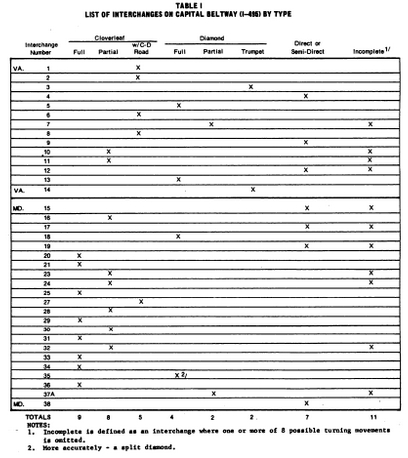
pg. 412 of the transcript
|
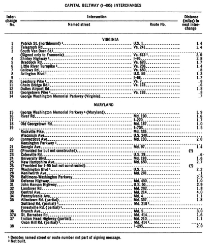
pg. 413 of the transcript
|
Posted: Fully posted; One state-named shield existed on the beltway itself - NB between the George Washington Pkwy and the Potomac River that lasted until late 2025. A bunch were replaced during the original Express Lanes project.
Multiplexes: I-95 (7.63 mi)
Legislative names: Capitol Beltway (since 4-21-60)
Other names: Inner (WB and NB) and Outer (EB and SB) Loops.
Scenic Byway: No segments
HOoT Exits:
Northbound (Inner Loop):
Entrance from I-495 south of SR 620 Braddock Rd
Entrance from SR 620 Braddock Rd
Entrance from SR 650 Gallows Rd
Exit to US 29/VA 237
Entrance and Exit from I-66
Exit to VA 7
Entrance and Exit from Westpark Dr
Entrance and Exit from Scotts Crossing Rd
Exit to VA 267 WB
Entrance from VA 267
Exit to GW Pkwy
Exit to I-495 north of GW Pkwy
|
Southbound (Outer Loop):
Entrance from I-495 north of GW Pkwy
Entrance from GW Pkwy
Entrance from EB and Exit to WB VA 267
Entrance and Exit from Scotts Crossing Rd
Entrance and Exit from Westpark Dr
Entrance from VA 7
Entrance from EB/WB and Exit to I-66 WB only
Entrance from US 29/VA 237
Exit to SR 650 Gallows Rd
Exit to SR 620 Braddock Rd
Exit to I-495 south of Braddock Rd (lanes transition shortly to Exits for I-95/395 Express Lanes)
|
Comments: I-495 mainline blows off US 29/VA 237 and VA 400 (save for a ramp at the US 1 exit that does connect to Washington St.) I-495 express lanes blow off entirely VA 236, US 50, and VA 123.
I-495 changed its milemarkers before it changed its exit numbers, which was a little weird.
These interchanges have been significantly modified:
SR 620 Braddock Rd was simple diamond, became a full clover
SR 650 Gallows Rd was a partial diamond (NB exit, entrance to SB), became full interchange with parclo
VA 7 was missing 495 SB to VA 7 NB and VA 7 SB to I-495 NB
VA 123 was missing 495 NB to VA 123 SB and VA 123 NB to I-495 SB
The US 1 and VA 241 interchanges are fundamentally the same but have been made more complicated with the Thru/Local lanes set-up.
There have been 3 crossings of the Beltway between SR 613 Van Dorn St and VA 241 that are now removed:
1. Bush Hill Dr overpass - An overpass was put in place to provide access to what is now Eisenhower Ave (no access to Eisenhower from Van Dorn existed then). Bush Hill Rd had a very narrow overpass over the railroad in this area by 1949 which was removed between 1980-88. The beltway overpass was removed between 1994-2002. It was located approximately at MM 173.6.
2. Clermont Dr underpass - this is now the exit to the Eisenhower Ave Connector. Originally north of the beltway here was inacessible from any other location though it was connected to the Bush Hill Rd area first before being accessible from anywhere else. This appears to have been usable up until the mid 1990s and may have lasted until construction on the Eisenhower Ave Connector interchange was begun.
3. Up until the 1950s it was possible to go on a continuous S. Quaker Ln from SR 644 via today's Norton Rd/Burgundy Rd/S. Quaker Ln across Cameron Run and the railroad to reach VA 236. The Cameron Run bridge disappeared in the 1950s, but a small neighborhood was built (Oak Park) that became cutoff by the beltway. An overpass was built directly north of today's Linehan St at Burgundy Park, with a frontage road east back to S. Quaker Ln. It appears that the Oak Park neighborhood and the Linehan St overpass were removed in the mid 1970s to construct the Metro Yard. Bluestone Rd may have been the west edge of the extinct neighborhood.
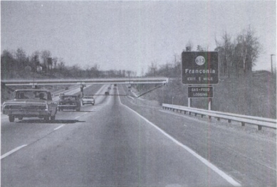
Photo showing the Bush Hill Rd overpass
Highway Safety, Design, and Operations - Freeway Signing and Geometrics 1969 Hearings (pg. 615)
|
Photo showing the Linehan Rd overpass and the frontage road leading back to S. Quaker Ln
Highway Safety, Design, and Operations - Freeway Signing and Geometrics 1969 Hearings (pg. 496)
|
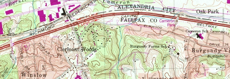
Topo showing the 3 crossings of the Beltway that are no longer present
1965 Topo
For a gallery of 1960s photos of I-495, go to the I-495 Vintage Gallery
|