VA 526 to 599
< VA 500 to 525 | Home | VA 600 to 699 >
VA 598 view
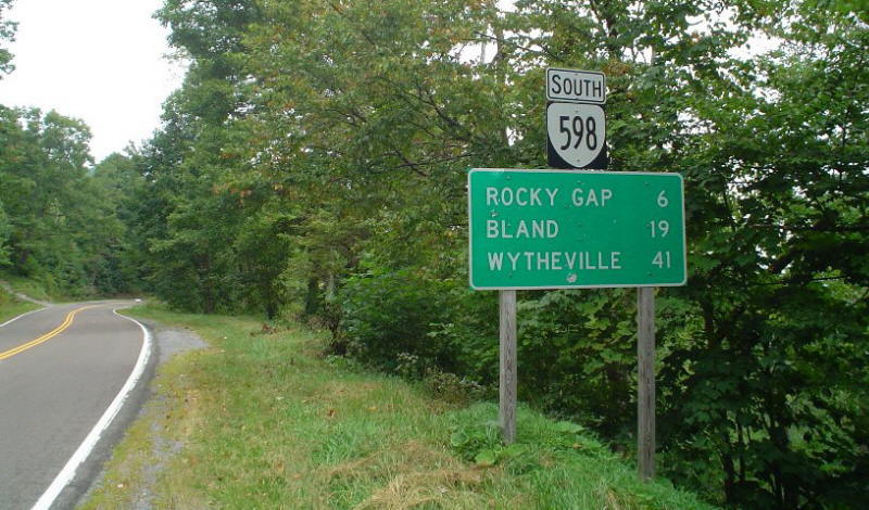
Photo: VA 598 begins its descent from the West Virginia line. (photo by Chris E 9/4/04)
VA 526  not currently assigned
Previous VA 526's:

1930 ROUTE LOG
US 13, VA 34: 0 - 0
Accomac-Northampton Line: 1.05 - 1.05
US 13, VA 34: 0.44 - 1.49


1932 ROUTE LOG
CR 135: 0 - 0
VA 522: 0.25 - 0.25
US 13, VA 34: 0.70 - 0.95
VA 526 #1: Appeared in August 1929 as new primary routing, running from US 13/VA 34 (now VA 181) Belle Haven Station to US 13/VA 34 (now VA 178) Exmore. This was shown but not labeled on 1930 Official maps.
About 1930, US 13/VA 34 was moved to this corridor, replacing all of VA 526.
VA 526 #2: Appeared in Dec 1930 (CTB), running from Exmore to Belle Haven. This had been part of US 13/VA 34. It appears that VA 526 extended to the north CL of Belle Haven at this time. I have no map that show this explicitly but the 1931 VDOT Route Log describes VA 526 as "Belle Haven to Exmore"
By 1932, VA 526 was rerouted to stay in Accomac County, heading east to US 13/VA 34 at Belle Haven Station, in a route swap with VA 522.
In July 1933, VA 526 was renumbered as VA 181.
1931 Official
VA 526 #1.
1932 Accomac County
VA 526 #2.
VA 527  not currently assigned
Previous VA 527's:

1932 ROUTE LOG
VA 10: 0 - 0
US 117, VA 10: 2.20 - 2.20
GAP IN ROUTE END VA 527: 1.7 - 2.7
US 117, VA 10: 5.00 - 7.20


1932 ROUTE LOG
US 13, VA 34: 0 - 0
CR 2-210: 1.6 - 1.6
VA 527 #1: Appeared in August 1929 (CTB) as new primary routing, running from VA 10 Suffolk east to US 117/VA 10 (now VA 337) Magnolia.
In June 1930 (CTB), a second piece of VA 527 appeared running from US 117/VA 10 (now VA 337) Alexanders Corner west 5 miles to the Bowers Hill area.
In late 1930, VA 527 was renumbered as part of VA 12. Today it is part of US 58 Business in Suffolk and US 58 in western Portsmouth/Chesapeake.

VA 527 #2: Appeared in Dec 1930 (CTB) as an upgrade to CR 7, running from US 13/VA 34 Nassawaddox 0.5 miles towards Franktown.
In July 1932 (CTB), VA 527 was extended over a little CR 101 and a little CR 2 over to Franktown.
In July 1933, VA 527 was renumbered to VA 184. Today it is part of SR 606 and SR 618.
1932 Northampton County
VA 528  not currently assigned
Previous VA 528's:

1932 ROUTE LOG
US 17, VA 514: 0 - 0
END VA 528: 4.4 - 4.4
VA 528: Appeared in August 1929 as new routing running from VA 514 (now US 17) Harris Grove east 2.95 miles.
In July 1932 (CTB), VA 528 was extended east over CR 101 through Seaford then north over CR 213 to end at the shore of Back Creek.
In July 1933, VA 528 was renumbered as part of VA 173. Today it is SR 718, which has only a fleeting duplex with VA 173 left in the primary system.
1932 Official
VA 529  not currently assigned
Previous VA 529's:

1932 ROUTE LOG
US 60, VA 39: 0 - 0
US 17, VA 515: 5.48 - 5.48
VA 517: 5.10 - 10.58
END VA 529: 1.20 - 11.78
VA 529: Appeared in June 1930 as new primary routing running from US 60/VA 39 Newport News northwest 5 miles towards Lee Hall.
In Dec 1930 (CTB), VA 529 was extended northwest 0.5 miles.
In July 1932 (CTB), VA 529 was extended northwest 6.28 miles. This would be a little north of VA 173.
In July 1933, VA 529 was renumbered as part of VA 168. Today it is part of VA 143.
VA 529 does not appear on any maps that I have.
VA 530  not currently assigned
Previous VA 530's:

1932 ROUTE LOG
US 13, VA 34: 0 - 0
CR 265A: 3.71 - 3.71
VA 530 #1: Appeared in June 1930 as new primary routing, 0.25 miles to connect Virginia and Huntington Ave. This was quickly renumbered to VA 39Y. The only explicit reference to this as being route 530 is in the March 1931 CTB which describes a permit being granted to a location on route 530.
VA 530 #2: In Dec 1930 (CTB), VA 530 was assigned to 3.5 miles of roads in each Warwick and York Counties to and through the Yorktown Park Reservation.
The June 1931 CTB makes an assignment of 6.5 miles total to describe the same thing.
In Feb 1932, an Act of the General Assembly decommissioned VA 530 and VA 530Y. It was noted that their purpose for creation in late 1930 was "...that the sections of roads in York and Warwick counties of approximately thirteen and one-half miles in length taken into the State highway system for improvement on account of the sesqui-centennial celebration at Yorktown..."
Both the Official Program of the 1931 Yorktown Sesquicentennial Celebration and the History of the Colonial Parkway mention that Virginia improved some roads specifically for the celebration, neither says what roads they are.
I believe these roads were taken into the system, which on the 1940 Warwick-York County maps add up to around the right distance:
SR 636: Richneck Rd from today's VA 173 to today's VA 105; the road used to continue north through Newport News Park to connect to the end of Siege Ln in York County, then connected directly to today's SR 634 northwest of SR 704 via roughly the auto tour road for Yorktown Monument
SR 637: Crawford Rd from today's VA 238 near Lebanon Church east to VA 238 Goosley Rd then east across current US 17 to SR 704
SR 638: Current VA 238 Goosley Rd between SR 1020 and SR 637.
SR 608: Current VA 105 Fort Eustis Blvd from US 60 to Richneck Rd
VA 530 #3: Created in July 1932 as an upgrade to CR 138, running from US 13/VA 34 Painter to CR 265A (now SR 605) Quinby.
In July 1933, VA 530 became VA 182. Not shown on the 1932 Accomac County map but is mentioned specifically in Aug 1932 CTB.
None of the VA 530s appears on any map I have seen.
VA 530Y: Both the Dec 1930 and June 1931 assignments to VA 530 specifically included VA 530Y as part of the mix. It was eliminated by Act of General Assembly in Feb 1932.
It is likely VA 530Y was more than one road.
VA 531  not currently assigned
Previous VA 531's:

1932 ROUTE LOG
CR 110: 0 - 0
US 13, VA 34: 3.70 - 3.70
CR 1: 2 - 5.70
VA 531: Appeared in Dec 1930 (CTB) as new primary routing, running from CR 110 (now SR 658) Guilford to CR 1 (now SR 679) Modestown. Had there been no Chincoteague bridge agreement in 1928, this would've been VA 520.
In July 1933, VA 531 was renumbered as VA 187.
1931 Official
VA 532  not currently assigned
Previous VA 532's:

1932 ROUTE LOG
VA 511: 0 - 0
Warwick-Elizabeth City Line: 2.9 - 2.9
VA 532: Appeared in Dec 1930 (CTB) as new primary routing, running on Shell Rd 0.20 miles from VA 511 (La Salle Ave).
In July 1932, VA 532 was extended to Newport News.
In July 1933, VA 532 became part of VA 168. Today it is just Shell Rd.
1932 Elizabeth City County
VA 533  not currently assigned
Previous VA 533's:

1932 ROUTE LOG
VA 514: 0 - 0
VA 513: 0.80 - 0.80
VA 533: Appeared in Dec 1930 (CTB) as new primary routing, running on Rip Rap Rd between VA 514 (now Back River Rd) and VA 513 (now just King St).
In July 1933, VA 533 became part of VA 167. Today it is not part of the primary system.
1932 Elizabeth City County
VA 534  not currently assigned
Previous VA 534's:

1931 ROUTE LOG
VA 12: 0 - 0
CR 5: 0 - 1.86


1932 ROUTE LOG
US 60, VA 39: 0 - 0
CR 100-200-226: 2.30 - 2.30
VA 534 #1: Appeared in Dec 1930 (CTB) as new primary routing, running from VA 12 (now old US 58 just west of I-95) Emporia north 1.86 miles towards Purdy.
In 1932, VA 534 was renumbered as an extended VA 509. Today it is part of SR 619.
VA 534 #2?: In July 1932 (CTB), a primary route was established from US 60/VA 39 Norge to Croaker, upgrading CR 100. In July 1933 this became VA 188. Based on the pattern of renumbering District 5, I believe this route was VA 534. Today it is mostly SR 607, but is also Norge Ln and Maxton Ln at the railroad crossing.
1931 Official
VA 535  not currently assigned
Previous VA 535's:

1932 ROUTE LOG
US 117, VA 507: 0 - 0
Nanesmond-Southampton Line: 4.82 - 4.82
US 58, VA 12: 8.87 - 13.69
VA 535: Appeared in Dec 1930 (CTB) as new primary routing, running 0.32 miles southwest from US 117/VA 12 (now US 58 Bus) Holland
In June 1931 (CTB), a second piece of VA 535 appeared, running from US 117/VA 507 (now US 258 Bus) Franklin southeast 1.69 miles.
In July 1932 (CTB),the two pieces of VA 535 were connected.
In July 1933, VA 535 became VA 189. Today this is SR 719; VA 189 (except loops with SRs 686; 666/615); VA 272; VA 189/US 58.
1931 Official
VA 535 initial routing.
1932 Official
VA 535 extended to Franklin
VA 536  not currently assigned
Previous VA 536's:

1932 ROUTE LOG
VA 502: 0 - 0
Norfolk-Princess Anne Line: 2.80 - 2.80
CR 1: 5.58 - 8.38
VA 536: Appeared in Dec 1930 (CTB) as new primary routing, running from VA 502 (now Bellpage Ave) near North Landing south to Pocanty Rd. A second stub appeared from the Norfolk-Princess Anne line south 0.38 miles.
In July 1932 (CTB), the small gap near the county line was connected, plus VA 536 was extended 5.2 more miles towards the Pungo Ferry, replacing CR 1.
In July 1933, VA 536 became part of VA 190. Today it is Blackwater Rd.
1932 Official
VA 537  not currently assigned
Previous VA 537's:

1932 ROUTE LOG
BEGIN VA 537: 0 - 0
US 13 SB, VA 34 SB: 1.30 - 1.30
US 13 NB, VA 34 NB: 0.20 - 1.50
CR 3: 3.57 - 5.07
VA 537: Appeared in December 1930 (CTB) as new primary routing, from Willis Wharf west 1.93 miles through Exmore.
In July 1932 (CTB), VA 537 was extended west over CR 3 3.14 miles towards Jamesville.
In July 1933, VA 537 became VA 183. East of Exmore is now SR 603.
1932 Northampton County
VA 538  not currently assigned
Previous VA 538's:

1932 ROUTE LOG
Sussex-Greensville Line: 0 - 0
US 17-1, VA 24: 0.90 - 0.90
CR 6: 3.03 - 3.93
GAP IN ROUTE
CR 117-212: 0 - 3.93
VA 48: 5.23 - 9.16
VA 538: Appeared in December 1930 (CTB) as new primary routing, running from VA 48 (now SR 634) Sussex CH south 2.69 miles towards Yale.
In July 1932 (CTB), VA 538 was extended north to the new VA 48 (current VA 40) and extended south 2.54 more miles to about Yale.
Also in July 1932, a second piece of VA 538 was born, running from the Greensville County line east through Jarratts 3.93 miles towards Yale.
In July 1933, both pieces of VA 538 became part of VA 32. Today, piece 1 is SR 735 and piece 2 is a little VA 139, a little SR 648 and SR 631.
1932 Official
VA 538 initial piece.
1932 Sussex County
VA 538 piece 2.
VA 539  not currently assigned
Previous VA 539's:

1932 ROUTE LOG
US 58, VA 12: 0 - 0
VA 10: 3.25 - 3.25
VA 539: Appeared in December 1930 as new primary routing, running from VA 12 (now US 58-460 ALT) Bowers Hill north to US 117/VA 10 (now VA 337).
In July 1933, VA 539 became VA 191. The northern end of VA 539 used today's Old Joliff Rd.
1932 Norfolk County
VA 540  not currently assigned
Previous VA 540's:

1932 ROUTE LOG
VA 522: 0 - 0
US 13, VA 34: 1.39 - 1.39
CR 11: 3.31 - 4.70
VA 540: Appeared in March 1931 (CTB) as new primary routing, running from VA 522 (now VA 126) Onancock to US 13/VA 34 Onley.
In July 1932 (CTB), VA 540 was extended east over CR 12 to end at CR 11 (now SR 606) Locustville.
In July 1933, VA 540 became VA 179. East of Onley is now SR 789.
1932 Accomac County
VA 541  not currently assigned
Previous VA 541's:

1932 ROUTE LOG
VA 10: 0 - 0
CR 2: 1.3 - 7.1
VA 541: Appeared in June 1931 (CTB) as an upgrade to CR 2, running 1.4 miles from VA 10 Chuckatuck east towards Crittenden.
In July 1932 (CTB), VA 541 was extended east 3 more miles to about Eclipse.
July 1933, VA 541 became VA 192. Today this is the westernmost bit of VA 125 plus SR 628.
1932 Nanesmond County
VA 542  not currently assigned
Previous VA 542's:

1932 ROUTE LOG
VA 514: 0 - 0
York-Elizabeth City Line: 1.5 - 1.5
VA 515: 2 - 3.5
CR 247: 4 - 7.5
VA 542: Appeared in May 1932 (CTB) as an upgrade to CR 4, running from VA 39 (now VA 5) Williamsburg north 3.5 miles towards Magruder.
In July 1932 (CTB), VA 542 was extended north 1.35 miles through Magruder towards Biglers Mill.
In July 1933, VA 542 became part of VA 31. Today it is Capitol Landing Rd; VA 5; VA 143; Williamsburg Rd within Camp Peary.
VA 542 is not on any map I have seen but it is explicitly mentioned in the CTB minues.
VA 543  not currently assigned
Previous VA 543's:

1932 ROUTE LOG
US 17, VA 40: 0 - 0
VA 27: 12.25 - 12.25
VA 543: Appeared in July 1932 (CTB) as an upgraded to CR 9, running from US 17/VA 40 (now the Dismal Swamp Bike Trail) Wallaceton east to VA 27 (now old VA 168) Northwest.
In July 1933, VA 543 became VA 193. Today it is Ballahack Rd.
VA 543 does not appear on any map I have seen nor is it explicitly named in the CTB Minutes. However it fits the pattern of how District 5 routes were renumbered in July 1933.
VA 544  not currently assigned
Previous VA 544's:

1932 ROUTE LOG
VA 35: 0 - 0
CR 8: 2.9 - 2.9
VA 544: Appeared in July 1932 (CTB) as an upgrade to CR 8, running from VA 35 southeast to the railroad line at Newsoms.
In July 1933, VA 544 became VA 194. Today it is SR 673.
VA 544 does not appear on any map I have seen nor is it explicitly named in the CTB Minutes. However it fits the pattern of how District 5 routes were renumbered in July 1933. Some 1933 Gousha maps erroneously show this as VA 554.
1933 Gousha
VA 545  not currently assigned
Previous VA 545's:

1932 ROUTE LOG
VA 509: 0 - 0
NC STATE LINE: 2.6 - 2.6
VA 545: Appeared in July 1932 (CTB) as an upgrade to CR 121, running from VA 509 (now VA 186) Branchville south to the North carolina line.
In July 1933, VA 545 became VA 195. Today it is SR 701.
VA 545 does not appear on any map I have seen nor is it explicitly named in the CTB Minutes. However it fits the pattern of how District 5 routes were renumbered in July 1933.
VA 546  not currently assigned
Previous VA 546's:

1932 ROUTE LOG
VA 510: 0 - 0
Surry-Sussex Line: 0.87 - 0.87
CR 1: 5.18 - 6.05
VA 546: Appeared in July 1932 (CTB) as an upgrade to CR 1, running from VA 510 (now VA 31) Wakefield east to about the Walls Bridge over Blackwater River towards Runnymede.
In July 1933, VA 546 became VA 196. Today, it is SR 617.
VA 546 is shown on the 1932 Sussex and Surry County maps.
1932 Surry County
VA 547  not currently assigned
Previous VA 547's:

1932 ROUTE LOG
CR 234-235: 0 - 0
VA 510: 2.00 - 2.00
VA 547: Appeared in July 1932 (CTB as an upgrade to CR 235, running from VA 510 (now SR 620-628 jct) south to CR 234 (now SR 600) towards Airfield Pond. The north end of VA 547 was also the south end of VA 510.
In July 1933, VA 547 became part of VA 31. Today it is SR 628.
VA 547 is shown on the 1932 Sussex County map.
1932 Sussex County
VA 548  not currently assigned
Previous VA 548's:

1932 ROUTE LOG
US 13, VA 34: 0 - 0
CR 116-117: 3.00 - 3.00
VA 548?: Appeared in July 1932 (CTB) as an upgrade to CR 116, running from US 13/VA 34 Accomac north 3 miles through Greenbush towards Parksley, ending at CR 117 (now SR 661).
In July 1933, VA 548 became VA 177. Today it is SR 764 and some SR 763.
VA 548 does not appear on any map I have seen nor is it explicitly named in the CTB Minutes. However it fits the pattern of how District 5 routes were assigned in July 1932. If it were not VA 548 it would have to be a weird separate piece of either VA 521 or VA 522, which I see as less likely.
I-564
I-581
I-595
From:   Rocky Gap (Bland County)
To:  WV line at Bluefield, Bland County (continues as WV 598 into Bluefield WV)
Total Length:  4.16 miles   The route continues as WV 598 to US 52 in Bluefield, WV.
ROUTE LOG
I-77 (exit 66), US 52: 0 - 0
WV STATE LINE: 4.16 - 4.16
Creation:  Appeared in 1980 as a renumbering of US 21-52. This has been the only VA 598.
Adjustments:  None
Improvements: Fully paved upon designation; no multilane segments.
Posting:  Fully posted. However, VA 598 is not mentioned on the SB I-77 BGS at this exit (only mentions US 52)
Multiplexes: None
Legislative names: None
Other Names: None
Scenic Byway: None
Comment:  Yes Virginia, there is a VA 598.  This is very nearly the highest theoretical primary state highway number which can be used until the secondary numbers take over at 600.  Why 598 was chosen, I have no idea. It would have made more sense to put US 52 on I-77 starting in Band and let old 52 to West Virginia be VA 98.  
There is a scenic overlook and old rest area at the state lione crossing on top of East River Mountain.
1981 Official
VA 599  not currently assigned
Previous VA 599's:


Apparently, projects whose routes had not been established were given a Route 599 designation. It is unlikely these were ever posted as such.
VA 599 #1: Appears in April and October 1961 CTB Minutes, referring to the bridge over Smith Creek in the City of Norfolk. There is only 1 bridge over that small waterway, which is Brambleton Ave. VA 150 was assigned to this route in 1962. Today it is US 58/VA 337.
VA 599 #2: Appears in the April 1960, April 1961, and October 1962 CTB Minutes, describing a project between State St. and Commonwealth Ave. I believe this refers to the Euclid Ave construction, which when finished became US 11W and US 421. The 1960 and 1961 entries in the CTB minutes erroneously call this VA 597 (project numbers are all labeled 599 however)
VA 599 #3: Appears in the March 1963 CTB Minutes as the project between VA 134A (Magruder Blvd) and the NASA entrance. This opened as the southernmost part of VA 172.
VA 599 #4: Appears in the April 1963 CTB Minutes as a project between Water St. and Brambleton Ave in Norfolk. I think this refers to Tidewater Drive here, which became VA 337 in 1963 or 1964.
VA 599 #5: Appears in May '63, June '64, and September '65 CTB minutes referring to the project between US 258 and Langley AFB at Tide Mill Creek. This opened as part of VA 167 (now just La Salle Ave).
VA 599 #6: Appears in September and October 1964 CTB minutes as the Leesburg Bypass project, which was partially done in the late 60's from VA 7 northward (posted as what I don't know). Eventually it became US 15.
VA 599 #7: Appears in October '65, July '66, and October '66 CTB minutes as the project on Pacific Ave below 5th St. in the City of Virginia Beach. This would be the Rudee Inlet Bridge, which is implied on maps as being US 60 at the time, but US 60 officially still uses Atlantic Ave to the last.
VA 599 #8: Appears in the April 1966 CTB referring to a project that extended VA 419 north from US 460 to I-81.
VA 599 #9: Appears in December 1966 CTB minutes referring to a project in King Georges County between SR 624 and SR 618. This later opened as an extension of VA 218.
VA 599 #10: Appeared in February, July, and August 1967 CTB Minutes as a project in Augusta County between US 11 and I-81. This later opened as VA 275. Now it is part of VA 262.

Previous: VA 500 - 525  |  Next: VA 600 - VA 699
Top  |  Virginia Hwy Index Home

Page last modified 26 February 2015