< US 123 | Home | US 176 ALT | US 176 Bus | US 178 >
|
|
|
| ROUTE LOG |
US 52: 0 - 0 US 17 ALT: 5.8 - 5.8 SC 311: 19.1 - 24.9 SC 27: 1.2 - 26.1 Orangeburg-Berkeley Line: 1.1 - 27.2 SC 453 SB: 4.6 - 31.8 SC 453 NB: 0.2 - 32.0 SC 310: 0.8 - 32.8 SC 314: 0.9 - 33.7 US 15, SC 45: 3.6 - 37.3 I-95 (exit 90): 2.6 - 39.9 SC 210: 1.0 - 40.9 US 301: 6.9 - 47.8 Calhoun-Orangeburg Line: 0.9 - 48.7 SC 33: 7.9 - 56.6 US 601: 6.9 - 63.5 SC 6 EB: 3.7 - 67.2 SC 6 WB: 0.5 - 67.7 US 21 SB: 11.9 - 79.6 Lexington-Calhoun Line: 6.1 - 85.7 I-26 (exit 119): 0.7 - 86.4 US 321 SB: 1.9 - 88.3 I-77: 3.0 - 91.3 I-26 (exit 115): 0.4 - 91.7 SC 2: 1.0 - 92.7 SC 302: 1.6 - 94.3 SC 35: 0.9 - 95.2 SC 2: 0.8 - 96.0 Richland-Lexington Line: 0.6 - 96.6 US 1, US 78: 1.0 - 97.6 SC 12: 0.4 - 98.0 I-126 Bus WB, US 76 WB: 0.5 - 98.5 SC 48: 0.6 - 99.1 I-126 Bus END, US 76 EB: 0.1 - 99.2 US 21 NB, US 321 NB: 0.5 - 99.7 SC 16: 1.0 - 100.7 I-20 (exit 65): 2.7 - 103.4 SC 60: 4.6 - 108.0 I-26 (exit 101), US 76 EB: 1.7 - 109.7 US 76 WB: 3.4 - 113.1 I-26 (exit 97): 2.0 - 115.1 Newberry-Richland Line: 7.9 - 123.0 SC 213: 3.0 - 126.0 SC 202: 2.3 - 128.3 SC 773: 1.5 - 129.8 SC 219: 1.8 - 131.6 SC 34: 5.7 - 137.3 SC 121 SB: 5.7 - 144.0 SC 72 WB: 7.3 - 151.3 Union-Newberry Line: 0.5 - 151.8 SC 72 EB, SC 121 NB: 1 - 152.8 SC 18, SC 215 SB: 14.1 - 166.9 SC 496: 1.4 - 168.3 SC 49: 0.3 - 168.6 SC 215 NB: 1.2 - 169.8 Spartanburg-Union Line: 11.9 - 181.7 SC 150: 1.0 - 182.7 SC 9 EB, SC 295: 2.0 - 184.7 I-585 BEGIN, US 29: 8.7 - 193.4 SC 296: 0.4 - 193.8 US 221: 1.2 - 195.0 SC 9 WB: 0.3 - 195.3 I-85 Bus (exit 5), I-585 END: 1.9 - 197.2 I-85 (exit 72): 1.0 - 198.2 SC 56: 0.4 - 198.6 I-26 (exit 15): 3.0 - 201.6 SC 292: 3.4 - 205.0 SC 357: 6.4 - 211.4 SC 11: 0.4 - 211.8 SC 14: 4.7 - 216.5 Greenville-Spartanburg Line: 1.9 - 218.4 NC STATE LINE: 0.8 - 219.2
|
Creation: Appeared in late 1926 as an original US Highway, attaching itself to SC 19 from US 76 Newberry via Union and Spartanburg to the North Carolina line above Landrum.
|
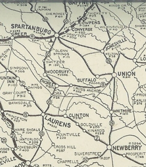
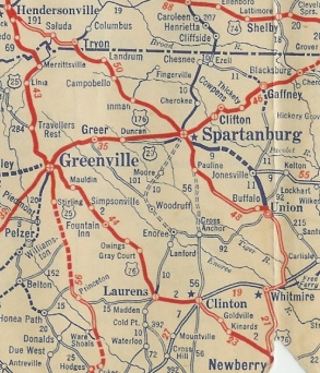
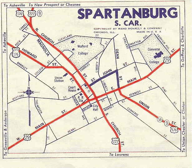
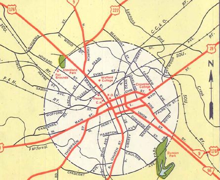
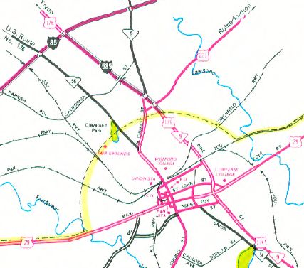
Adjustments: In 1928, SC 19 was dropped from US 176. About 1929, US 176 was removed from today's S-44-40 in Buffalo. In 1931 (bridge dates), US 176 was removed from today's S-42-866 between Gramling and Campobello; Old Asheville Hwy north of Campobello; Peach St/S-42-924/S-42-480 south of Landrum. In 1932 (bridge date), US 176 was removed from Old John Dodd Rd north of Spartanburg About 1934, US 176 was removed from Mt. Vernon Rd south of Union. Also, if US 176 used what Google calls Old US 176 south of the Tyger River and east of the current highway, it was moved to today's S-44-192 Old US 176 on the west side of the current highway. Also US 176 was removed from the Hodges Rd loop just north of SC 72. In 1934 or 1935, US 176 was given new routing into Spartanburg from the north, via Church St. The previous route using Howard St and Magnolia St became US 176 ALT (now S-42-2 and S-42-1766).
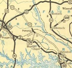
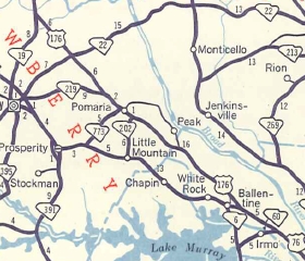
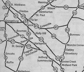
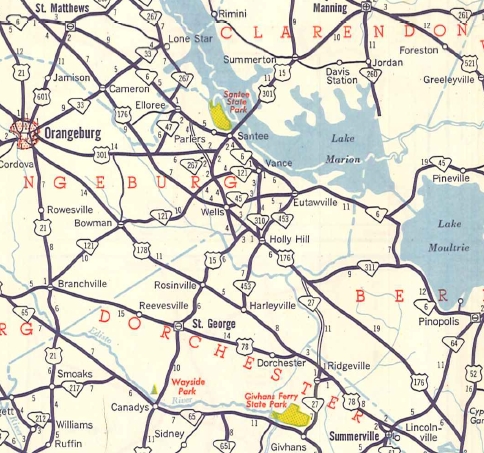
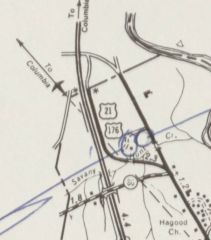
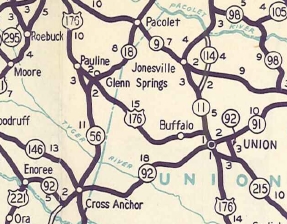
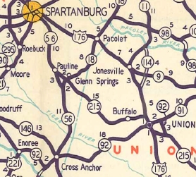
It appears that about 1937, US 176 was placed on its bypass of Inman and Campton, leaving behind US 176 ALT (now S-42-13, a bit of SC 292, and S-42-11). In 1949, US 176 was rerouted between Union and Spartanburg, by heading north to Jonesville (replacing part of SC 11) and multiplexing with SC 9 from Jonesville through Pacolet to Spartanburg, along Pine St. The old way became an extended SC 215 from Union to Pauline and SC 56 from Pauline to Spartanburg. In 1951, US 176 was rerouted below Whitmire and extended southeast replacing SC 177 to Ballentine; added to US 76 to Columbia; added to US 21 to Sandy Run; replaced SC 31 to end at US 52 Goose Creek. The old piece from Newberry north to old SC 177 became an extended SC 19 (now SC 121).
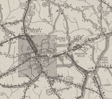
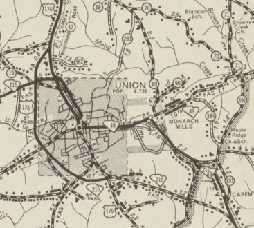
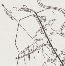
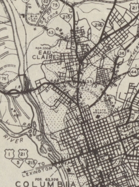
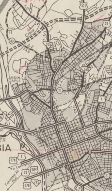
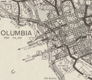
Originally, US 176 in Columbia followed Main St to Elmwood, then west to Assembly, south to Gervais, and followed US 1 west across the Saluda River (this was a 6-plex of routes: US 1-21-176-321-378 and SC 215). US 176 followed US 1 to Charleston Hwy (SC 602's beginning) before heading south towards Dixiana. In 1954 or 1955, US 176 was rerouted in Columbia to continue south on Assembly to Blossom St before heading west across the Saluda River on the current US 176 bridge. The old route remained US 1-378 to West Columbia, then southward on Charleston Hwy became a bit of SC 602 with the rest becoming a US 1-21 connector. About 1956, US 176 was placed on a new bypass west of Union, leaving behind US 176 Business (current SC 18).
Between 1957-59, US 176 was removed from S-44-524 Hebron Church Rd south of Union and also from S-44-192 Old US 176 at the Tyger River In 1960, US 176 was changed to continue along Pine St, connecting with the new I-585 and further new construction northwest back to the original routing. Church St became SC 56.
Between 1958-67, US 176 was rerouted onto new alignment to avoid what is now the Eastman Chemical plant east of I-26 Exit 119.
In 1978, US 176 was removed from Assembly St in Columbia and rerouted along Huger St like today. Assembly St became an extended SC 48.
About 1991, US 176 was rerouted north of Union onto new 4-lane construction as it runs today. For a while, US 176 ended at S-44-12 and used it to jog east to Jonesville. The old route became part of SC 18 and the SC 9 part remained. US 176 was taken off S-44-12 and put on more new 4-lane routing in 1992, leaving behind SC 9 from Jonesville to Pacolet.
Improvements: Fully paved upon designation only in the immediate Spartanburg area. In 1928, US 176 was paved from the NC Line down to a little below Pauline. In 1929, US 176 was paved from Buffalo to Union. In 1931, US 176 was paved from Pauline to Buffalo. In 1932, US 176 was paved from Newberry most of the way to Whitmire. In 1933, US 176 was paved the rest of the way to Whitmire. In 1934, US 176 was paved from Whitmire to Union. The first piece of US 176 to be 4-lane was from US 29 to I-85 (along I-585) in 1960. In 1961, US 176 was widened on its SC 72 overlay. By 1963, US 176 was multilane from US 29 east a couple miles; Broad River to SC 16; the entire US 321 multiplex. In 1968 or 1969, US 176 was 4-laned between SC 60 and the Broad River and also from I-26 to SC 56. In 1975, US 176 was 4-laned from I-26 west to SC 292, and east of Spartanburg almost to Pacolet. No official maps have ever shown that the Union bypass is 4-lane, but it was already that way the first time I drove it in 1987. The new construction of US 176 between Union and near Pacolet were 4-laned upon completion as described above. The first couple miles off US 52 were 4-laned by 1993. In 1997, US 176 was 4-laned between US 17 ALT and US 52. Comment: US 176 was the first US route I ever completed, and it is the longest US route I've driven all at once. US 176 below Columbia follows the Old State Road, which was an important route in the early days of South Carolina. US 176 has also been rerouted just east of I-26 exit 115 to bypass the Kodak-Eastman Plant. I don't know when this was done (done by 1986, though) and the old road goes right through the center of the facility. US 176 below Columbia has many stretches of straight road, up to 11 miles long. US 176 TRUCK has been signed around the south side of Holly Hill since the early 90's, using S-38-68. | ||||||||||||||||||||||||||


Previous: US 123 |
Next: US 176 ALT | US 176 Bus | US 178
Top | South Carolina Hwy Index
Home
Page last modified 16 August 2017